
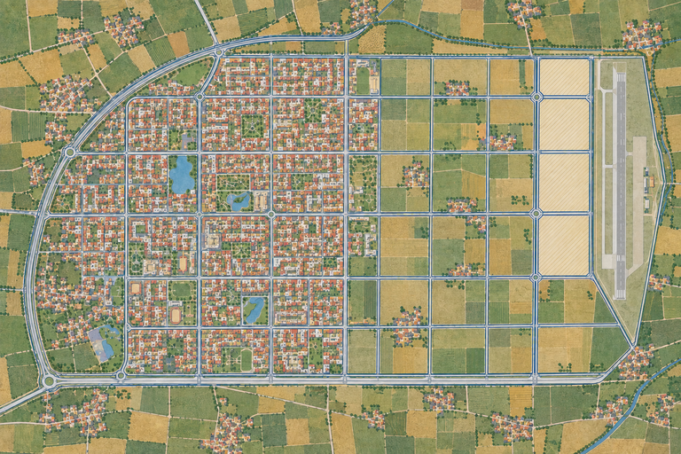
Every town in the Greater Mohali Region has a master plan. Mohali's is the one the others were drawn around.
It projects a population of 12,95,000 by 2031 and 17,26,500 by 2056. It classifies Mohali not as a town but as a Metropolitan Town. It works across an available land area of 16,674 hectares, which is roughly four times the Zirakpur planning area.
The plan explains where those numbers came from.
The document
The Master Plan for S.A.S Nagar, 2006 to 2031 was prepared by Jurong Consultants Pte Ltd of Singapore for GMADA, under the Department of Town and Country Planning, Punjab, and approved by the Government of Punjab.
Every other plan in the series runs 2008 to 2031. Mohali's starts in 2006, because Mohali is where the regional exercise began.
GMADA publishes it in three parts on its own site: the Plan, the Report, and the Revenue Master Plan.
Where 13 lakh came from
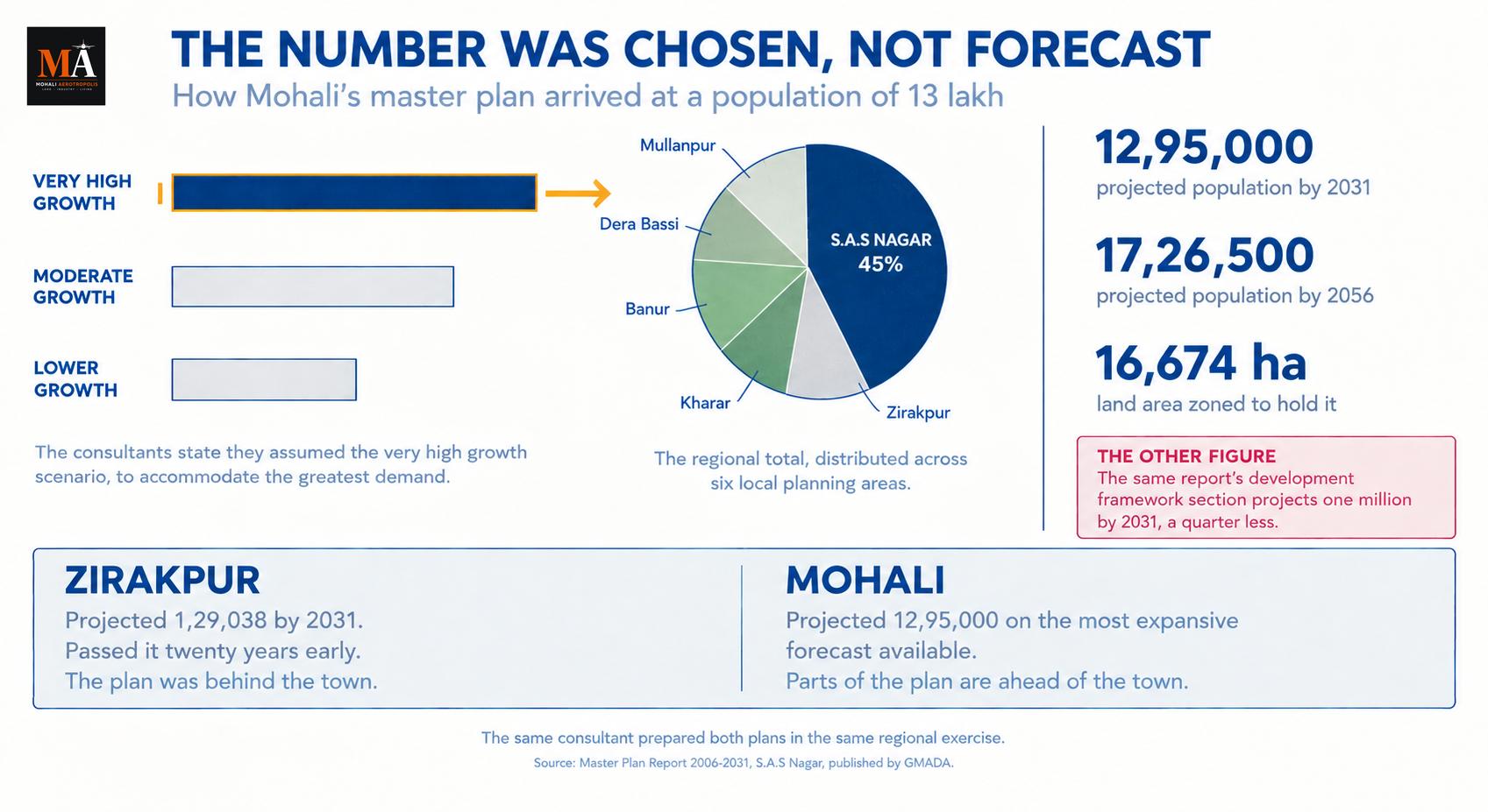
The regional exercise modelled several growth scenarios for the Greater Mohali Region. For the purpose of land use planning, the consultants state that they assumed the very high growth scenario, in order to accommodate the greatest demand and to maximise GMADA's potential to develop into a competitive region on par with successful cities elsewhere.
Having taken the most expansive of the available forecasts, they then distributed that population across the six local planning areas, with S.A.S Nagar taking the main share at 45 per cent.
So the 12,95,000 figure is not a prediction of what Mohali would most likely become. It is the share Mohali received of the largest number the region's planners were prepared to model. The plan is built to accommodate that outcome rather than to forecast it.
There is a second figure in the same report that sits oddly beside it. The development framework section states that Mohali's population is projected to increase to one million by 2031, which is a quarter less than the headline number. The report carries both.
Planning parameters follow from the larger figure: a gross residential density of 175 persons per acre, across that 16,674 hectare area.
What Mohali was meant to become
The vision in the report is unusually declarative. Mohali was to be a premier township in the Greater Mohali area of Punjab and the benchmark for other towns in India to emulate, a showcase environment for its citizens to live, work, play, learn and strike business deals.
The land use drawing shows what that meant in practice, and Mohali's zone list is materially richer than any other town's in the series.
Alongside the ordinary categories of residential, commercial, institution, park and rural and agriculture, Mohali's plan carries two separate grades of mixed use, an industry zone specifically for technology and research and development, a separate industry and warehouse zone, a wholesale centre, an expo site, a sports and recreation zone, and a PR centre on the arterial network.
It also carries something the other plans do not: a recurring designation called the Floral Mile, running through the plan at several points as a landscape feature.
And it carries three separate parcels marked Reserve Site, Airport Expansion, alongside a zone for airport facilities. The plan set aside land for an airport to grow into, which is the single clearest link between this document and the Aerotropolis that followed.
The problems the plan named
The report is direct about what stood in the way.
It states that the GMADA area is land locked, with connections to other cities and countries possible only by air, road and rail.
It states that the local road network is far from ideal, with limited connectivity to Mullanpur and Panchkula from Mohali.
And it observes that the various towns within the Greater Mohali Region are not directly connected to each other.
Those three sentences describe the regional road programme that followed. The PR alignments running through every plan in the series, PR-4, PR-5, PR-6, PR-7 and PR-11, exist to answer exactly that diagnosis. So does the elevated road now recommended for sanction on the Mohali to New Chandigarh route, and so does the bypass now contracted around Zirakpur. A decade and a half after the plan named limited connectivity to Mullanpur and Panchkula as a constraint, both of those links are still being built.
The report also flags competing developments in the vicinity as a constraint, Mohali being the most urbanised town in the region while other centres grew around it, and notes the need to organise informal markets within the planning area.
The mirror image of Zirakpur
The same consultant made opposite errors in the same exercise.
Zirakpur's plan projected 1,29,038 people by 2031. The town passed that figure twenty years early and the state's own revision put it on course for more than eight lakh. The plan was far too small, and the consequences are visible in the roads that were built over and the drainage that was never laid.
Mohali's plan went the other way. It took the most expansive forecast available, assigned Mohali nearly half the region's population, and zoned 16,674 hectares to hold it.
In Zirakpur the risk is that the plan is behind the town. In Mohali the risk is that parts of the plan are ahead of it, with land zoned for uses that assume a population that has not yet arrived. A wholesale centre, an expo site and a technology and research zone are all provisions for a city of 13 lakh people.
What the plan can tell you, and what it cannot
It tells you the zone, and the zone is specific. Mohali's plan distinguishes between industry for technology and research and industry for warehousing, and between two grades of mixed use. A parcel described simply as commercial or industrial has not been described.
It tells you what is reserved. The three airport expansion reserve sites, the river reserve, the forest and open space zones and the utility reservations are land that was never intended to carry ordinary development. Vacant land next to a plot is not always land awaiting a buyer.
It does not tell you the stage. Zoning says what may be built. It says nothing about whether the sector is serviced, whether it has been acquired, or whether an acquisition notification is running over it. GMADA's own public notices for Sectors 87, 101 and 103 sit on the same page as the master plan.
And it does not tell you the colony is legal. In a planning area of 16,674 hectares, the approval status of any individual colony is a separate check against a separate list.
Mohali's master plan is the most ambitious document in the GMADA series, and it states the assumption it rests on. The city was planned for 13 lakh people because the planners chose the largest number they were willing to model. Everything zoned in it follows from that choice.
---
Sources
- Master Plan Report 2006-2031, S.A.S Nagar, Jurong Consultants Pte Ltd for the Greater Mohali Area Development Authority, for the very high growth scenario assumption, the 45 per cent regional share, the projected populations of 12,95,000 by 2031 and 17,26,500 by 2056, the Metropolitan Town classification, the 16,674 hectare land area, the gross residential density of 175 persons per acre, the vision statement, and the constraints on connectivity and the land locked region
- S.A.S Nagar (2031), Greater Mohali Area Development Authority, for the Plan, Report and Revenue Master Plan, and for the current public notices on land acquisition in Sectors 87, 101 and 103
- S.A.S Nagar land use plan drawing, a published copy of the drawing sheet, for the zone categories including the two mixed use grades, industry for technology and research and development, industry and warehouse, wholesale centre, expo, PR centre, Floral Mile, river reserve and the three airport expansion reserve sites, and for the PR road alignments. The authoritative version is the Plan file on GMADA's own site
हर कस्बे का ग्रेटर मोहाली क्षेत्र में एक मास्टर प्लान है। मोहाली का वह है जिसके चारों ओर बाकी सब बनाए गए।
यह 2031 तक 12,95,000 और 2056 तक 17,26,500 की जनसंख्या का अनुमान लगाता है। यह मोहाली को एक कस्बा नहीं बल्कि एक Metropolitan Town के रूप में वर्गीकृत करता है। यह 16,674 हेक्टेयर के उपलब्ध भूमि क्षेत्र पर काम करता है, जो ज़ीरकपुर की योजना क्षेत्र का लगभग चार गुना है।
यह योजना बताती है कि ये संख्याएँ कहाँ से आईं।
दस्तावेज़
मास्टर प्लान फॉर S.A.S Nagar, 2006 से 2031 सिंगापुर के Jurong Consultants Pte Ltd द्वारा GMADA के लिए, पंजाब के Department of Town and Country Planning के अंतर्गत तैयार किया गया और पंजाब सरकार द्वारा अनुमोदित किया गया।
इस श्रृंखला की हर अन्य योजना 2008 से 2031 तक चलती है। मोहाली की 2006 में शुरू होती है, क्योंकि मोहाली वह जगह है जहाँ से क्षेत्रीय अभ्यास शुरू हुआ।
GMADA इसे अपनी साइट पर तीन भागों में प्रकाशित करता है: Plan, Report, और Revenue Master Plan।
13 लाख कहाँ से आया
क्षेत्रीय अभ्यास ने ग्रेटर मोहाली क्षेत्र के लिए कई विकास परिदृश्यों का मॉडल तैयार किया। भूमि उपयोग योजना के उद्देश्य से, परामर्शदाता बताते हैं कि उन्होंने very high growth scenario मान लिया, ताकि सबसे बड़ी मांग को समायोजित किया जा सके और GMADA की क्षमता को अन्य सफल शहरों के बराबर एक प्रतिस्पर्धी क्षेत्र के रूप में विकसित करने को अधिकतम किया जा सके।
उपलब्ध पूर्वानुमानों में से सबसे व्यापक को चुनने के बाद, उन्होंने उस जनसंख्या को छह स्थानीय योजना क्षेत्रों में वितरित किया, जिसमें S.A.S Nagar को 45 प्रतिशत का मुख्य हिस्सा मिला।
इसलिए 12,95,000 का आंकड़ा इस बात की भविष्यवाणी नहीं है कि मोहाली सबसे अधिक संभावना से क्या बनेगा। यह उस सबसे बड़ी संख्या का हिस्सा है जो क्षेत्र के योजनाकार मॉडल करने को तैयार थे, जो मोहाली को मिला। योजना उस परिणाम को समायोजित करने के लिए बनाई गई है, न कि उसका पूर्वानुमान लगाने के लिए।
उसी रिपोर्ट में एक दूसरा आंकड़ा है जो इसके बगल में विचित्र लगता है। विकास ढांचे वाला अनुभाग बताता है कि मोहाली की जनसंख्या 2031 तक दस लाख तक बढ़ने का अनुमान है, जो मुख्य आंकड़े से एक चौथाई कम है। रिपोर्ट दोनों को शामिल करती है।
योजना मानक बड़े आंकड़े से निकलते हैं: उस 16,674 हेक्टेयर क्षेत्र में 175 व्यक्ति प्रति एकड़ का सकल आवासीय घनत्व।
मोहाली को क्या बनना था
रिपोर्ट में दृष्टि असामान्य रूप से घोषणात्मक है। मोहाली को पंजाब के ग्रेटर मोहाली क्षेत्र में एक प्रमुख टाउनशिप और भारत के अन्य कस्बों के लिए अनुकरण करने योग्य मानक बनना था, जो अपने नागरिकों के लिए जीने, काम करने, खेलने, सीखने और व्यापार सौदे करने का एक प्रदर्शनी वातावरण हो।
भूमि उपयोग ड्राइंग दिखाती है कि व्यवहार में इसका क्या अर्थ था, और मोहाली की ज़ोन सूची श्रृंखला में किसी भी अन्य कस्बे की तुलना में कहीं अधिक समृद्ध है।
आवासीय, वाणिज्यिक, संस्थागत, पार्क और ग्रामीण एवं कृषि की सामान्य श्रेणियों के साथ-साथ, मोहाली की योजना में mixed use के दो अलग ग्रेड, विशेष रूप से प्रौद्योगिकी और अनुसंधान एवं विकास के लिए एक उद्योग ज़ोन, एक अलग उद्योग और गोदाम ज़ोन, एक थोक केंद्र, एक एक्सपो स्थल, एक खेल और मनोरंजन ज़ोन, और मुख्य मार्ग नेटवर्क पर एक PR केंद्र शामिल है।
इसमें वह भी शामिल है जो अन्य योजनाओं में नहीं है: Floral Mile नाम का एक आवर्ती पदनाम, जो परिदृश्य विशेषता के रूप में योजना में कई स्थानों पर चलता है।
और इसमें हवाई अड्डे की सुविधाओं के लिए एक ज़ोन के साथ-साथ Reserve Site, Airport Expansion चिह्नित तीन अलग पार्सल शामिल हैं। योजना ने एक हवाई अड्डे के विस्तार के लिए भूमि अलग रखी, जो इस दस्तावेज़ और उसके बाद के Aerotropolis के बीच सबसे स्पष्ट कड़ी है।
योजना ने जो समस्याएँ बताईं
रिपोर्ट इस बारे में स्पष्ट है कि रास्ते में क्या था।
यह बताती है कि GMADA क्षेत्र land locked है, अन्य शहरों और देशों से संबंध केवल हवाई, सड़क और रेल द्वारा संभव है।
यह बताती है कि स्थानीय सड़क नेटवर्क far from ideal है, मोहाली से मुल्लांपुर और पंचकूला तक सीमित कनेक्टिविटी है।
और यह देखती है कि ग्रेटर मोहाली क्षेत्र के भीतर के विभिन्न कस्बे एक-दूसरे से सीधे जुड़े नहीं हैं।
ये तीन वाक्य उस क्षेत्रीय सड़क कार्यक्रम का वर्णन करते हैं जो इसके बाद आया। श्रृंखला की हर योजना में चलने वाले PR अलाइनमेंट, PR-4, PR-5, PR-6, PR-7 और PR-11, ठीक उसी निदान का उत्तर देने के लिए मौजूद हैं। ऐसा ही वह एलिवेटेड रोड भी है जिसे अब मोहाली से न्यू चंडीगढ़ मार्ग पर मंजूरी के लिए अनुशंसित किया गया है, और ऐसा ही वह बाईपास भी है जिसका अब ज़ीरकपुर के चारों ओर अनुबंध हो चुका है। योजना द्वारा मुल्लांपुर और पंचकूला तक सीमित कनेक्टिविटी को बाधा के रूप में नामित करने के डेढ़ दशक बाद, वे दोनों लिंक अभी भी बन रहे हैं।
रिपोर्ट आसपास के प्रतिस्पर्धी विकासों को भी एक बाधा के रूप में चिह्नित करती है, मोहाली क्षेत्र का सबसे अधिक शहरीकृत कस्बा है जबकि अन्य केंद्र इसके चारों ओर बढ़े, और योजना क्षेत्र के भीतर अनौपचारिक बाजारों को व्यवस्थित करने की आवश्यकता पर ध्यान देती है।
ज़ीरकपुर का दर्पण प्रतिबिंब
उसी परामर्शदाता ने उसी अभ्यास में विपरीत गलतियाँ कीं।
ज़ीरकपुर की योजना ने 2031 तक 1,29,038 लोगों का अनुमान लगाया था। कस्बे ने वह आंकड़ा बीस साल पहले पार कर लिया और राज्य के अपने संशोधन ने इसे आठ लाख से अधिक की दिशा में रखा। योजना बहुत छोटी थी, और इसके परिणाम उन सड़कों में दिखते हैं जिन पर निर्माण हो गया और उस जल निकासी में जो कभी बिछाई ही नहीं गई।
मोहाली की योजना दूसरी दिशा में गई। इसने उपलब्ध सबसे व्यापक पूर्वानुमान लिया, मोहाली को क्षेत्र की लगभग आधी जनसंख्या सौंपी, और उसे समायोजित करने के लिए 16,674 हेक्टेयर ज़ोन किया।
ज़ीरकपुर में जोखिम यह है कि योजना कस्बे से पीछे है। मोहाली में जोखिम यह है कि योजना के कुछ हिस्से उससे आगे हैं, ऐसे उपयोगों के लिए ज़ोन की गई भूमि के साथ जो ऐसी जनसंख्या मानते हैं जो अभी नहीं आई है। एक थोक केंद्र, एक एक्सपो स्थल और एक प्रौद्योगिकी और अनुसंधान ज़ोन सभी 13 लाख लोगों के शहर के लिए प्रावधान हैं।
योजना आपको क्या बता सकती है, और क्या नहीं
यह आपको ज़ोन बताती है, और ज़ोन विशिष्ट है। मोहाली की योजना प्रौद्योगिकी और अनुसंधान के लिए उद्योग और भंडारण के लिए उद्योग के बीच अंतर करती है, और mixed use के दो ग्रेड के बीच। केवल वाणिज्यिक या औद्योगिक के रूप में वर्णित पार्सल का वर्णन नहीं किया गया है।
यह आपको बताती है कि क्या आरक्षित है। तीन हवाई अड्डा विस्तार आरक्षित स्थल, नदी आरक्षित, वन और खुली जगह ज़ोन और उपयोगिता आरक्षण वह भूमि है जिसे सामान्य विकास के लिए कभी नहीं चाहा गया था। किसी भूखंड के बगल की खाली भूमि हमेशा खरीदार की प्रतीक्षा करती भूमि नहीं होती।
यह आपको चरण नहीं बताती। ज़ोनिंग बताती है कि क्या बनाया जा सकता है। यह कुछ नहीं बताती कि सेक्टर में सेवाएँ हैं या नहीं, क्या उसका अधिग्रहण हो चुका है, या क्या उस पर कोई अधिग्रहण अधिसूचना चल रही है। सेक्टर 87, 101 और 103 के लिए GMADA की अपनी सार्वजनिक सूचनाएँ मास्टर प्लान के उसी पृष्ठ पर हैं।
और यह आपको नहीं बताती कि कॉलोनी वैध है। 16,674 हेक्टेयर के योजना क्षेत्र में, किसी भी व्यक्तिगत कॉलोनी की स्वीकृति स्थिति एक अलग सूची के विरुद्ध एक अलग जाँच है।
मोहाली का मास्टर प्लान GMADA श्रृंखला का सबसे महत्वाकांक्षी दस्तावेज़ है, और यह उस धारणा को बताता है जिस पर वह टिका है। शहर 13 लाख लोगों के लिए योजनाबद्ध किया गया था क्योंकि योजनाकारों ने सबसे बड़ी संख्या चुनी जिसे वे मॉडल करने को तैयार थे। इसमें ज़ोन की गई हर चीज़ उस चुनाव से निकलती है।
---
स्रोत
- Master Plan Report 2006-2031, S.A.S Nagar, Jurong Consultants Pte Ltd द्वारा Greater Mohali Area Development Authority के लिए, very high growth scenario की धारणा, 45 प्रतिशत क्षेत्रीय हिस्सा, 2031 तक 12,95,000 और 2056 तक 17,26,500 की अनुमानित जनसंख्या, Metropolitan Town वर्गीकरण, 16,674 हेक्टेयर भूमि क्षेत्र, 175 व्यक्ति प्रति एकड़ का सकल आवासीय घनत्व, दृष्टि वक्तव्य, और कनेक्टिविटी तथा land locked क्षेत्र की बाधाओं के लिए
- S.A.S Nagar (2031), Greater Mohali Area Development Authority, Plan, Report और Revenue Master Plan के लिए, और सेक्टर 87, 101 और 103 में भूमि अधिग्रहण पर वर्तमान सार्वजनिक सूचनाओं के लिए
- S.A.S Nagar land use plan drawing, ड्राइंग शीट की एक प्रकाशित प्रति, ज़ोन श्रेणियों के लिए जिनमें दो mixed use ग्रेड, प्रौद्योगिकी और अनुसंधान एवं विकास के लिए उद्योग, उद्योग और गोदाम, थोक केंद्र, एक्सपो, PR केंद्र, Floral Mile, नदी आरक्षित और तीन हवाई अड्डा विस्तार आरक्षित स्थल, और PR सड़क अलाइनमेंट के लिए। आधिकारिक संस्करण GMADA की अपनी साइट पर Plan फ़ाइल है
ਹਰੇਕ ਕਸਬੇ ਦਾ ਗ੍ਰੇਟਰ ਮੋਹਾਲੀ ਖੇਤਰ ਵਿੱਚ ਇੱਕ ਮਾਸਟਰ ਪਲਾਨ ਹੁੰਦਾ ਹੈ। ਮੋਹਾਲੀ ਦਾ ਉਹ ਹੈ ਜਿਸਦੇ ਦੁਆਲੇ ਬਾਕੀਆਂ ਨੂੰ ਡਿਜ਼ਾਈਨ ਕੀਤਾ ਗਿਆ ਸੀ।
ਇਹ 2031 ਤੱਕ 12,95,000 ਅਤੇ 2056 ਤੱਕ 17,26,500 ਦੀ ਆਬਾਦੀ ਦਾ ਅਨੁਮਾਨ ਲਗਾਉਂਦਾ ਹੈ। ਇਹ ਮੋਹਾਲੀ ਨੂੰ ਇੱਕ ਕਸਬਾ ਨਹੀਂ ਸਗੋਂ ਇੱਕ Metropolitan Town ਵਜੋਂ ਵਰਗੀਕ੍ਰਿਤ ਕਰਦਾ ਹੈ। ਇਹ 16,674 ਹੈਕਟੇਅਰ ਦੇ ਉਪਲਬਧ ਖੇਤਰ ਵਿੱਚ ਕੰਮ ਕਰਦਾ ਹੈ, ਜੋ ਜੀਰਕਪੁਰ ਪਲਾਨਿੰਗ ਖੇਤਰ ਤੋਂ ਲਗਭਗ ਚਾਰ ਗੁਣਾ ਹੈ।
ਇਹ ਪਲਾਨ ਦੱਸਦਾ ਹੈ ਕਿ ਇਹ ਅੰਕੜੇ ਕਿੱਥੋਂ ਆਏ।
ਦਸਤਾਵੇਜ਼
Master Plan for S.A.S Nagar, 2006 to 2031 ਸਿੰਗਾਪੁਰ ਦੇ Jurong Consultants Pte Ltd ਦੁਆਰਾ GMADA ਲਈ, ਟਾਊਨ ਐਂਡ ਕੰਟਰੀ ਪਲਾਨਿੰਗ ਵਿਭਾਗ, ਪੰਜਾਬ ਦੇ ਅਧੀਨ, ਤਿਆਰ ਕੀਤਾ ਗਿਆ ਸੀ ਅਤੇ ਪੰਜਾਬ ਸਰਕਾਰ ਦੁਆਰਾ ਮਨਜ਼ੂਰ ਕੀਤਾ ਗਿਆ ਸੀ।
ਇਸ ਲੜੀ ਵਿੱਚ ਹਰੇਕ ਹੋਰ ਪਲਾਨ 2008 ਤੋਂ 2031 ਤੱਕ ਚੱਲਦਾ ਹੈ। ਮੋਹਾਲੀ ਦਾ 2006 ਵਿੱਚ ਸ਼ੁਰੂ ਹੁੰਦਾ ਹੈ, ਕਿਉਂਕਿ ਮੋਹਾਲੀ ਉਹ ਥਾਂ ਹੈ ਜਿੱਥੋਂ ਖੇਤਰੀ ਅਭਿਆਸ ਸ਼ੁਰੂ ਹੋਇਆ ਸੀ।
GMADA ਇਸਨੂੰ ਆਪਣੀ ਸਾਈਟ 'ਤੇ ਤਿੰਨ ਭਾਗਾਂ ਵਿੱਚ ਪ੍ਰਕਾਸ਼ਿਤ ਕਰਦਾ ਹੈ: ਪਲਾਨ, ਰਿਪੋਰਟ, ਅਤੇ ਰੈਵੇਨਿਊ ਮਾਸਟਰ ਪਲਾਨ।
13 ਲੱਖ ਕਿੱਥੋਂ ਆਏ
ਖੇਤਰੀ ਅਭਿਆਸ ਨੇ ਗ੍ਰੇਟਰ ਮੋਹਾਲੀ ਖੇਤਰ ਲਈ ਕਈ ਵਿਕਾਸ ਢਾਂਚਿਆਂ ਦਾ ਮਾਡਲ ਤਿਆਰ ਕੀਤਾ। ਜ਼ਮੀਨੀ ਵਰਤੋਂ ਪਲਾਨਿੰਗ ਦੇ ਉਦੇਸ਼ ਲਈ, ਸਲਾਹਕਾਰ ਦੱਸਦੇ ਹਨ ਕਿ ਉਨ੍ਹਾਂ ਨੇ ਬਹੁਤ ਉੱਚ ਵਿਕਾਸ ਢਾਂਚੇ ਨੂੰ ਮੰਨਿਆ, ਤਾਂ ਜੋ ਸਭ ਤੋਂ ਵੱਧ ਮੰਗ ਨੂੰ ਪੂਰਾ ਕੀਤਾ ਜਾ ਸਕੇ ਅਤੇ GMADA ਦੀ ਇੱਕ ਪ੍ਰਤੀਯੋਗੀ ਖੇਤਰ ਵਜੋਂ ਵਿਕਸਤ ਹੋਣ ਦੀ ਸਮਰੱਥਾ ਨੂੰ ਵੱਧ ਤੋਂ ਵੱਧ ਕੀਤਾ ਜਾ ਸਕੇ, ਜੋ ਹੋਰਨਾਂ ਥਾਵਾਂ ਦੇ ਸਫਲ ਸ਼ਹਿਰਾਂ ਦੇ ਬਰਾਬਰ ਹੋਵੇ।
ਉਪਲਬਧ ਪੂਰਵਾਨੁਮਾਨਾਂ ਵਿੱਚੋਂ ਸਭ ਤੋਂ ਵਿਸਤ੍ਰਿਤ ਲੈਣ ਤੋਂ ਬਾਅਦ, ਉਨ੍ਹਾਂ ਨੇ ਫਿਰ ਉਸ ਆਬਾਦੀ ਨੂੰ ਛੇ ਸਥਾਨਕ ਪਲਾਨਿੰਗ ਖੇਤਰਾਂ ਵਿੱਚ ਵੰਡਿਆ, ਜਿਸ ਵਿੱਚ S.A.S Nagar ਨੇ 45 ਪ੍ਰਤੀਸ਼ਤ ਦੇ ਨਾਲ ਮੁੱਖ ਹਿੱਸਾ ਲਿਆ।
ਇਸ ਲਈ 12,95,000 ਦਾ ਅੰਕੜਾ ਇਹ ਭਵਿੱਖਬਾਣੀ ਨਹੀਂ ਹੈ ਕਿ ਮੋਹਾਲੀ ਸਭ ਤੋਂ ਵੱਧ ਸੰਭਾਵਨਾ ਨਾਲ ਕੀ ਬਣੇਗਾ। ਇਹ ਉਸ ਸਭ ਤੋਂ ਵੱਡੇ ਅੰਕੜੇ ਦਾ ਹਿੱਸਾ ਹੈ ਜੋ ਖੇਤਰ ਦੇ ਪਲਾਨਰ ਤਿਆਰ ਸਨ ਮਾਡਲ ਬਣਾਉਣ ਲਈ, ਅਤੇ ਮੋਹਾਲੀ ਨੂੰ ਮਿਲਿਆ। ਪਲਾਨ ਉਸ ਨਤੀਜੇ ਨੂੰ ਸਮਾਉਣ ਲਈ ਬਣਾਇਆ ਗਿਆ ਹੈ ਨਾ ਕਿ ਉਸਦੀ ਭਵਿੱਖਬਾਣੀ ਕਰਨ ਲਈ।
ਉਸੇ ਰਿਪੋਰਟ ਵਿੱਚ ਇੱਕ ਦੂਜਾ ਅੰਕੜਾ ਹੈ ਜੋ ਇਸਦੇ ਨਾਲ ਅਜੀਬ ਲੱਗਦਾ ਹੈ। ਵਿਕਾਸ ਢਾਂਚਾ ਭਾਗ ਕਹਿੰਦਾ ਹੈ ਕਿ ਮੋਹਾਲੀ ਦੀ ਆਬਾਦੀ 2031 ਤੱਕ ਦਸ ਲੱਖ ਤੱਕ ਵਧਣ ਦਾ ਅਨੁਮਾਨ ਹੈ, ਜੋ ਮੁੱਖ ਅੰਕੜੇ ਤੋਂ ਇੱਕ ਚੌਥਾਈ ਘੱਟ ਹੈ। ਰਿਪੋਰਟ ਦੋਵੇਂ ਰੱਖਦੀ ਹੈ।
ਪਲਾਨਿੰਗ ਮਾਪਦੰਡ ਵੱਡੇ ਅੰਕੜੇ ਤੋਂ ਆਉਂਦੇ ਹਨ: ਉਸ 16,674 ਹੈਕਟੇਅਰ ਖੇਤਰ ਵਿੱਚ 175 ਵਿਅਕਤੀ ਪ੍ਰਤੀ ਏਕੜ ਦੀ ਕੁੱਲ ਰਿਹਾਇਸ਼ੀ ਘਨਤਾ।
ਮੋਹਾਲੀ ਨੂੰ ਕੀ ਬਣਨਾ ਸੀ
ਰਿਪੋਰਟ ਵਿੱਚ ਦ੍ਰਿਸ਼ਟੀ ਅਸਾਧਾਰਨ ਤੌਰ 'ਤੇ ਸਪਸ਼ਟ ਹੈ। ਮੋਹਾਲੀ ਨੂੰ ਪੰਜਾਬ ਦੇ ਗ੍ਰੇਟਰ ਮੋਹਾਲੀ ਖੇਤਰ ਵਿੱਚ ਇੱਕ ਪ੍ਰਮੁੱਖ ਟਾਊਨਸ਼ਿਪ ਅਤੇ ਭਾਰਤ ਦੇ ਹੋਰਨਾਂ ਕਸਬਿਆਂ ਲਈ ਅਨੁਕਰਣ ਦਾ ਮਾਪਦੰਡ ਬਣਨਾ ਸੀ, ਆਪਣੇ ਨਾਗਰਿਕਾਂ ਲਈ ਰਹਿਣ, ਕੰਮ ਕਰਨ, ਖੇਡਣ, ਸਿੱਖਣ ਅਤੇ ਕਾਰੋਬਾਰੀ ਸੌਦੇ ਕਰਨ ਲਈ ਇੱਕ ਪ੍ਰਦਰਸ਼ਨੀ ਵਾਤਾਵਰਣ।
ਜ਼ਮੀਨੀ ਵਰਤੋਂ ਦੀ ਡਰਾਇੰਗ ਦਿਖਾਉਂਦੀ ਹੈ ਕਿ ਅਮਲ ਵਿੱਚ ਇਸਦਾ ਕੀ ਮਤਲਬ ਸੀ, ਅਤੇ ਮੋਹਾਲੀ ਦੀ ਜ਼ੋਨ ਸੂਚੀ ਲੜੀ ਵਿੱਚ ਕਿਸੇ ਵੀ ਹੋਰ ਕਸਬੇ ਨਾਲੋਂ ਵਸਤੂਨਿਸ਼ਠ ਤੌਰ 'ਤੇ ਵਧੇਰੇ ਅਮੀਰ ਹੈ।
ਰਿਹਾਇਸ਼ੀ, ਵਪਾਰਕ, ਸੰਸਥਾਗਤ, ਪਾਰਕ ਅਤੇ ਦਿਹਾਤੀ ਅਤੇ ਖੇਤੀਬਾੜੀ ਦੀਆਂ ਆਮ ਸ਼੍ਰੇਣੀਆਂ ਦੇ ਨਾਲ, ਮੋਹਾਲੀ ਦੇ ਪਲਾਨ ਵਿੱਚ ਮਿਸ਼ਰਤ ਵਰਤੋਂ ਦੇ ਦੋ ਵੱਖਰੇ ਦਰਜੇ, ਖਾਸ ਤੌਰ 'ਤੇ ਤਕਨਾਲੋਜੀ ਅਤੇ ਖੋਜ ਅਤੇ ਵਿਕਾਸ ਲਈ ਇੱਕ ਉਦਯੋਗ ਜ਼ੋਨ, ਇੱਕ ਵੱਖਰਾ ਉਦਯੋਗ ਅਤੇ ਵੇਅਰਹਾਊਸ ਜ਼ੋਨ, ਇੱਕ wholesale centre, ਇੱਕ expo ਸਾਈਟ, ਇੱਕ ਖੇਡ ਅਤੇ ਮਨੋਰੰਜਨ ਜ਼ੋਨ, ਅਤੇ ਆਰਟੀਰੀਅਲ ਨੈੱਟਵਰਕ 'ਤੇ ਇੱਕ PR centre ਸ਼ਾਮਲ ਹੈ।
ਇਸ ਵਿੱਚ ਇੱਕ ਚੀਜ਼ ਵੀ ਹੈ ਜੋ ਹੋਰ ਪਲਾਨਾਂ ਵਿੱਚ ਨਹੀਂ: Floral Mile ਨਾਮ ਦਾ ਇੱਕ ਆਵਰਤੀ ਨਾਮਕਰਣ, ਜੋ ਪਲਾਨ ਵਿੱਚ ਕਈ ਥਾਵਾਂ 'ਤੇ ਇੱਕ ਲੈਂਡਸਕੇਪ ਵਿਸ਼ੇਸ਼ਤਾ ਵਜੋਂ ਚੱਲਦਾ ਹੈ।
ਅਤੇ ਇਸ ਵਿੱਚ ਹਵਾਈ ਅੱਡੇ ਦੀਆਂ ਸਹੂਲਤਾਂ ਲਈ ਇੱਕ ਜ਼ੋਨ ਦੇ ਨਾਲ Reserve Site, Airport Expansion ਵਜੋਂ ਨਿਸ਼ਾਨਿਤ ਤਿੰਨ ਵੱਖਰੇ ਹਿੱਸੇ ਹਨ। ਪਲਾਨ ਨੇ ਇੱਕ ਹਵਾਈ ਅੱਡੇ ਦੇ ਵਿਕਸਤ ਹੋਣ ਲਈ ਜ਼ਮੀਨ ਰੱਖੀ, ਜੋ ਇਸ ਦਸਤਾਵੇਜ਼ ਅਤੇ ਇਸ ਤੋਂ ਬਾਅਦ ਆਏ Aerotropolis ਵਿਚਕਾਰ ਸਭ ਤੋਂ ਸਪਸ਼ਟ ਕੜੀ ਹੈ।
ਪਲਾਨ ਵਿੱਚ ਦੱਸੀਆਂ ਸਮੱਸਿਆਵਾਂ
ਰਿਪੋਰਟ ਸਿੱਧੀ ਗੱਲ ਕਰਦੀ ਹੈ ਕਿ ਰਾਹ ਵਿੱਚ ਕੀ ਖੜ੍ਹਾ ਸੀ।
ਇਹ ਦੱਸਦੀ ਹੈ ਕਿ GMADA ਖੇਤਰ land locked ਹੈ, ਹੋਰਨਾਂ ਸ਼ਹਿਰਾਂ ਅਤੇ ਦੇਸ਼ਾਂ ਨਾਲ ਸੰਬੰਧ ਸਿਰਫ਼ ਹਵਾ, ਸੜਕ ਅਤੇ ਰੇਲ ਰਾਹੀਂ ਹੀ ਸੰਭਵ ਹਨ।
ਇਹ ਦੱਸਦੀ ਹੈ ਕਿ ਸਥਾਨਕ ਸੜਕ ਨੈੱਟਵਰਕ ਆਦਰਸ਼ ਤੋਂ ਬਹੁਤ ਦੂਰ ਹੈ, ਮੋਹਾਲੀ ਤੋਂ ਮੁੱਲਾਂਪੁਰ ਅਤੇ ਪੰਚਕੂਲਾ ਨਾਲ ਸੀਮਤ ਸੰਪਰਕ ਦੇ ਨਾਲ।
ਅਤੇ ਇਹ ਨਿਰੀਖਣ ਕਰਦੀ ਹੈ ਕਿ ਗ੍ਰੇਟਰ ਮੋਹਾਲੀ ਖੇਤਰ ਦੇ ਅੰਦਰ ਵੱਖ-ਵੱਖ ਕਸਬੇ ਇੱਕ ਦੂਜੇ ਨਾਲ ਸਿੱਧੇ ਤੌਰ 'ਤੇ ਜੁੜੇ ਨਹੀਂ ਹਨ।
ਇਹ ਤਿੰਨ ਵਾਕ ਉਸ ਖੇਤਰੀ ਸੜਕ ਪ੍ਰੋਗਰਾਮ ਦਾ ਵਰਣਨ ਕਰਦੇ ਹਨ ਜੋ ਬਾਅਦ ਵਿੱਚ ਆਇਆ। ਲੜੀ ਦੇ ਹਰੇਕ ਪਲਾਨ ਵਿੱਚ ਚੱਲਣ ਵਾਲੇ PR ਅਲਾਈਨਮੈਂਟ, PR-4, PR-5, PR-6, PR-7 ਅਤੇ PR-11, ਬਿਲਕੁਲ ਉਸੇ ਨਿਦਾਨ ਦਾ ਜਵਾਬ ਦੇਣ ਲਈ ਮੌਜੂਦ ਹਨ। ਇਸੇ ਤਰ੍ਹਾਂ ਮੋਹਾਲੀ ਤੋਂ ਨਿਊ ਚੰਡੀਗੜ੍ਹ ਰੂਟ 'ਤੇ ਮਨਜ਼ੂਰੀ ਲਈ ਹੁਣ ਸਿਫ਼ਾਰਸ਼ ਕੀਤੀ ਗਈ ਉੱਚੀ ਸੜਕ, ਅਤੇ ਇਸੇ ਤਰ੍ਹਾਂ ਜੀਰਕਪੁਰ ਦੇ ਦੁਆਲੇ ਹੁਣ ਠੇਕੇ 'ਤੇ ਦਿੱਤਾ ਗਿਆ ਬਾਈਪਾਸ। ਪਲਾਨ ਦੁਆਰਾ ਮੁੱਲਾਂਪੁਰ ਅਤੇ ਪੰਚਕੂਲਾ ਨਾਲ ਸੀਮਤ ਸੰਪਰਕ ਨੂੰ ਇੱਕ ਰੁਕਾਵਟ ਵਜੋਂ ਨਾਮਜ਼ਦ ਕਰਨ ਦੇ ਡੇਢ ਦਹਾਕੇ ਬਾਅਦ ਵੀ, ਉਹ ਦੋਵੇਂ ਕੜੀਆਂ ਅਜੇ ਵੀ ਬਣ ਰਹੀਆਂ ਹਨ।
ਰਿਪੋਰਟ ਨੇ ਨੇੜੇ-ਤੇੜੇ ਮੁਕਾਬਲੇ ਵਾਲੇ ਵਿਕਾਸਾਂ ਨੂੰ ਵੀ ਇੱਕ ਰੁਕਾਵਟ ਵਜੋਂ ਚਿੰਨ੍ਹਿਤ ਕੀਤਾ ਹੈ, ਮੋਹਾਲੀ ਖੇਤਰ ਦਾ ਸਭ ਤੋਂ ਸ਼ਹਿਰੀਕ੍ਰਿਤ ਕਸਬਾ ਹੋਣ ਦੇ ਨਾਲ ਜਦੋਂ ਹੋਰ ਕੇਂਦਰ ਇਸਦੇ ਦੁਆਲੇ ਵਧੇ, ਅਤੇ ਪਲਾਨਿੰਗ ਖੇਤਰ ਦੇ ਅੰਦਰ ਗੈਰ-ਰਸਮੀ ਮੰਡੀਆਂ ਨੂੰ ਸੰਗਠਿਤ ਕਰਨ ਦੀ ਲੋੜ ਨੂੰ ਨੋਟ ਕੀਤਾ।
ਜੀਰਕਪੁਰ ਦਾ ਸ਼ੀਸ਼ੇ ਵਾਲਾ ਪ੍ਰਤੀਬਿੰਬ
ਉਸੇ ਸਲਾਹਕਾਰ ਨੇ ਉਸੇ ਅਭਿਆਸ ਵਿੱਚ ਉਲਟੀਆਂ ਗਲਤੀਆਂ ਕੀਤੀਆਂ।
ਜੀਰਕਪੁਰ ਦੇ ਪਲਾਨ ਨੇ 2031 ਤੱਕ 1,29,038 ਲੋਕਾਂ ਦਾ ਅਨੁਮਾਨ ਲਗਾਇਆ। ਕਸਬੇ ਨੇ ਉਹ ਅੰਕੜਾ ਵੀਹ ਸਾਲ ਪਹਿਲਾਂ ਪਾਰ ਕਰ ਲਿਆ ਅਤੇ ਰਾਜ ਦੀ ਆਪਣੀ ਸੋਧ ਨੇ ਇਸਨੂੰ ਅੱਠ ਲੱਖ ਤੋਂ ਵੱਧ ਦੇ ਰਾਹ 'ਤੇ ਪਾ ਦਿੱਤਾ। ਪਲਾਨ ਬਹੁਤ ਛੋਟਾ ਸੀ, ਅਤੇ ਨਤੀਜੇ ਉਹਨਾਂ ਸੜਕਾਂ ਵਿੱਚ ਦਿਖਾਈ ਦਿੰਦੇ ਹਨ ਜਿਨ੍ਹਾਂ ਉੱਤੇ ਬਣਾਇਆ ਗਿਆ ਅਤੇ ਉਸ ਡਰੇਨੇਜ ਵਿੱਚ ਜੋ ਕਦੇ ਨਹੀਂ ਵਿਛਾਇਆ ਗਿਆ।
ਮੋਹਾਲੀ ਦਾ ਪਲਾਨ ਦੂਜੇ ਪਾਸੇ ਗਿਆ। ਇਸਨੇ ਉਪਲਬਧ ਸਭ ਤੋਂ ਵਿਸਤ੍ਰਿਤ ਪੂਰਵਾਨੁਮਾਨ ਲਿਆ, ਮੋਹਾਲੀ ਨੂੰ ਖੇਤਰ ਦੀ ਲਗਭਗ ਅੱਧੀ ਆਬਾਦੀ ਸੌਂਪੀ, ਅਤੇ ਇਸਨੂੰ ਰੱਖਣ ਲਈ 16,674 ਹੈਕਟੇਅਰ ਜ਼ੋਨ ਕੀਤੇ।
ਜੀਰਕਪੁਰ ਵਿੱਚ ਜੋਖਮ ਇਹ ਹੈ ਕਿ ਪਲਾਨ ਕਸਬੇ ਤੋਂ ਪਿੱਛੇ ਹੈ। ਮੋਹਾਲੀ ਵਿੱਚ ਜੋਖਮ ਇਹ ਹੈ ਕਿ ਪਲਾਨ ਦੇ ਕੁਝ ਹਿੱਸੇ ਇਸ ਤੋਂ ਅੱਗੇ ਹਨ, ਜ਼ਮੀਨ ਅਜਿਹੀਆਂ ਵਰਤੋਂਆਂ ਲਈ ਜ਼ੋਨ ਕੀਤੀ ਗਈ ਹੈ ਜੋ ਇੱਕ ਅਜਿਹੀ ਆਬਾਦੀ ਮੰਨਦੀਆਂ ਹਨ ਜੋ ਅਜੇ ਨਹੀਂ ਆਈ। ਇੱਕ wholesale centre, ਇੱਕ expo ਸਾਈਟ ਅਤੇ ਇੱਕ ਤਕਨਾਲੋਜੀ ਅਤੇ ਖੋਜ ਜ਼ੋਨ ਸਭ 13 ਲੱਖ ਲੋਕਾਂ ਦੇ ਸ਼ਹਿਰ ਲਈ ਪ੍ਰਬੰਧ ਹਨ।
ਪਲਾਨ ਤੁਹਾਨੂੰ ਕੀ ਦੱਸ ਸਕਦਾ ਹੈ, ਅਤੇ ਕੀ ਨਹੀਂ ਦੱਸ ਸਕਦਾ
ਇਹ ਤੁਹਾਨੂੰ ਜ਼ੋਨ ਦੱਸਦਾ ਹੈ, ਅਤੇ ਜ਼ੋਨ ਖਾਸ ਹੈ। ਮੋਹਾਲੀ ਦਾ ਪਲਾਨ ਤਕਨਾਲੋਜੀ ਅਤੇ ਖੋਜ ਲਈ ਉਦਯੋਗ ਅਤੇ ਵੇਅਰਹਾਊਸਿੰਗ ਲਈ ਉਦਯੋਗ ਵਿਚਕਾਰ, ਅਤੇ ਮਿਸ਼ਰਤ ਵਰਤੋਂ ਦੇ ਦੋ ਦਰਜਿਆਂ ਵਿਚਕਾਰ ਫ਼ਰਕ ਕਰਦਾ ਹੈ। ਸਿਰਫ਼ ਵਪਾਰਕ ਜਾਂ ਉਦਯੋਗਿਕ ਵਜੋਂ ਦੱਸਿਆ ਗਿਆ ਹਿੱਸਾ ਦੱਸਿਆ ਨਹੀਂ ਗਿਆ ਹੈ।
ਇਹ ਤੁਹਾਨੂੰ ਦੱਸਦਾ ਹੈ ਕਿ ਕੀ ਰਾਖਵਾਂ ਹੈ। ਤਿੰਨ ਹਵਾਈ ਅੱਡਾ ਵਿਸਥਾਰ ਰਾਖਵੇਂ ਸਥਾਨ, ਨਦੀ ਰਾਖਵਾਂ, ਜੰਗਲ ਅਤੇ ਖੁੱਲ੍ਹੀ ਥਾਂ ਜ਼ੋਨ ਅਤੇ ਉਪਯੋਗਤਾ ਰਾਖਵਾਂਪਨ ਉਹ ਜ਼ਮੀਨ ਹੈ ਜੋ ਕਦੇ ਆਮ ਵਿਕਾਸ ਲਈ ਨਹੀਂ ਸੀ। ਇੱਕ ਪਲਾਟ ਦੇ ਅੱਗੇ ਖਾਲੀ ਜ਼ਮੀਨ ਹਮੇਸ਼ਾ ਖਰੀਦਦਾਰ ਦੀ ਉਡੀਕ ਕਰ ਰਹੀ ਜ਼ਮੀਨ ਨਹੀਂ ਹੁੰਦੀ।
ਇਹ ਤੁਹਾਨੂੰ ਪੜਾਅ ਨਹੀਂ ਦੱਸਦਾ। ਜ਼ੋਨਿੰਗ ਦੱਸਦੀ ਹੈ ਕਿ ਕੀ ਬਣਾਇਆ ਜਾ ਸਕਦਾ ਹੈ। ਇਹ ਕੁਝ ਨਹੀਂ ਦੱਸਦੀ ਕਿ ਸੈਕਟਰ ਵਿੱਚ ਸੇਵਾਵਾਂ ਹਨ ਜਾਂ ਨਹੀਂ, ਕੀ ਇਹ ਹਾਸਲ ਕੀਤਾ ਗਿਆ ਹੈ, ਜਾਂ ਕੀ ਇਸ ਉੱਤੇ ਕੋਈ ਐਕਵਿਜ਼ੀਸ਼ਨ ਨੋਟਿਸ ਚੱਲ ਰਿਹਾ ਹੈ। ਸੈਕਟਰ 87, 101 ਅਤੇ 103 ਲਈ GMADA ਦੇ ਆਪਣੇ ਜਨਤਕ ਨੋਟਿਸ ਮਾਸਟਰ ਪਲਾਨ ਵਾਲੇ ਸਫ਼ੇ 'ਤੇ ਹੀ ਹਨ।
ਅਤੇ ਇਹ ਤੁਹਾਨੂੰ ਨਹੀਂ ਦੱਸਦਾ ਕਿ ਕਾਲੋਨੀ ਕਾਨੂੰਨੀ ਹੈ। 16,674 ਹੈਕਟੇਅਰ ਦੇ ਪਲਾਨਿੰਗ ਖੇਤਰ ਵਿੱਚ, ਕਿਸੇ ਵੀ ਵਿਅਕਤੀਗਤ ਕਾਲੋਨੀ ਦੀ ਮਨਜ਼ੂਰੀ ਸਥਿਤੀ ਇੱਕ ਵੱਖਰੀ ਸੂਚੀ ਦੇ ਵਿਰੁੱਧ ਇੱਕ ਵੱਖਰੀ ਜਾਂਚ ਹੈ।
ਮੋਹਾਲੀ ਦਾ ਮਾਸਟਰ ਪਲਾਨ GMADA ਲੜੀ ਵਿੱਚ ਸਭ ਤੋਂ ਮਹੱਤਵਾਕਾਂਖੀ ਦਸਤਾਵੇਜ਼ ਹੈ, ਅਤੇ ਇਹ ਉਹ ਧਾਰਨਾ ਦੱਸਦਾ ਹੈ ਜਿਸ 'ਤੇ ਇਹ ਟਿਕਿਆ ਹੈ। ਸ਼ਹਿਰ 13 ਲੱਖ ਲੋਕਾਂ ਲਈ ਯੋਜਨਾਬੱਧ ਕੀਤਾ ਗਿਆ ਸੀ ਕਿਉਂਕਿ ਪਲਾਨਰਾਂ ਨੇ ਸਭ ਤੋਂ ਵੱਡਾ ਅੰਕੜਾ ਚੁਣਿਆ ਜੋ ਉਹ ਮਾਡਲ ਬਣਾਉਣ ਲਈ ਤਿਆਰ ਸਨ। ਇਸ ਵਿੱਚ ਜੋ ਵੀ ਜ਼ੋਨ ਕੀਤਾ ਗਿਆ ਹੈ ਉਹ ਉਸ ਚੋਣ ਦਾ ਨਤੀਜਾ ਹੈ।
---
ਸਰੋਤ
- Master Plan Report 2006-2031, S.A.S Nagar, Jurong Consultants Pte Ltd ਵੱਲੋਂ ਗ੍ਰੇਟਰ ਮੋਹਾਲੀ ਏਰੀਆ ਡਿਵੈਲਪਮੈਂਟ ਅਥਾਰਟੀ ਲਈ, ਬਹੁਤ ਉੱਚ ਵਿਕਾਸ ਢਾਂਚਾ ਧਾਰਨਾ, 45 ਪ੍ਰਤੀਸ਼ਤ ਖੇਤਰੀ ਹਿੱਸਾ, 2031 ਤੱਕ 12,95,000 ਅਤੇ 2056 ਤੱਕ 17,26,500 ਦੀ ਅਨੁਮਾਨਿਤ ਆਬਾਦੀ, Metropolitan Town ਵਰਗੀਕਰਣ, 16,674 ਹੈਕਟੇਅਰ ਜ਼ਮੀਨੀ ਖੇਤਰ, 175 ਵਿਅਕਤੀ ਪ੍ਰਤੀ ਏਕੜ ਦੀ ਕੁੱਲ ਰਿਹਾਇਸ਼ੀ ਘਨਤਾ, ਦ੍ਰਿਸ਼ਟੀ ਬਿਆਨ, ਅਤੇ ਸੰਪਰਕ ਅਤੇ land locked ਖੇਤਰ ਦੀਆਂ ਰੁਕਾਵਟਾਂ ਲਈ
- S.A.S Nagar (2031), ਗ੍ਰੇਟਰ ਮੋਹਾਲੀ ਏਰੀਆ ਡਿਵੈਲਪਮੈਂਟ ਅਥਾਰਟੀ, ਪਲਾਨ, ਰਿਪੋਰਟ ਅਤੇ