
Zirakpur has a master plan. What it does not have is a town that followed it.
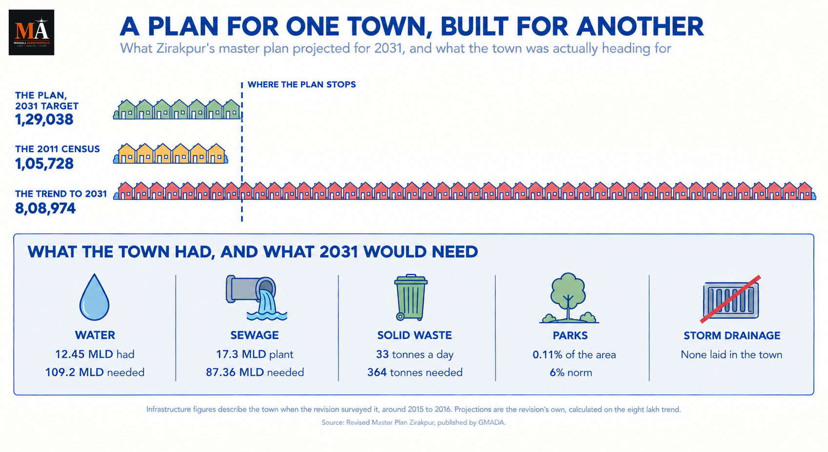
The original plan for the Zirakpur Local Planning Area projected a population of 1,29,038 by 2031. The 2011 census counted 1,05,728 people in the same area, twenty years early. The state's own revision of the plan concluded that Zirakpur would cross its 2031 target within two years, and that on the trend it was running, the planning area was heading for 8,08,974 people by 2031.
A plan built for one and a quarter lakh people, governing a town headed for eight. Nearly everything else about Zirakpur follows from that gap.
Two plans, not one
The original Master Plan 2008-2031 for the Zirakpur Local Planning Area was prepared by Jurong Consultants of Singapore for PUDA, under the regional plan for the Greater Mohali Region that the same consultant drew up. The report places Zirakpur among that region's local planning areas, alongside Central SAS Nagar, Dera Bassi, Banur, Kharar and Mullanpur.
The Punjab government then commissioned a revision, and appointed NF Infratech Service Pvt Ltd of New Delhi to prepare it. That revised report, prepared around 2015 to 2016, is the document GMADA publishes today as the Zirakpur 2031 plan report.
The Jurong plan is the original vision. The revision is the correction, written once it was clear the original had been overtaken.
What the original plan imagined
The Jurong vision was ambitious. Zirakpur was to become a regional centre for the Greater Mohali Region, a premier business hub and what the plan called a distinctive playground for the area. The rivers and their waterfronts were to be enhanced into the town's prime physical assets, with renewable energy, zero effluent discharge, abundant greenery and a walkable environment.
The regional plan also assigned Zirakpur a specific economic role: hardcore manufacturing, warehousing and medium and small manufacturing, with 572 hectares allocated for industry.
That is the town on paper. The revision describes the one that got built instead.
The roads that were built over
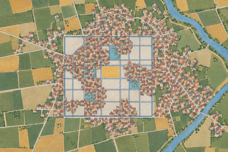
The revised report records that proposed roads in the Zirakpur master plan had been encroached by built-up area, and that those proposals therefore cannot be implemented. It names the places: Singhpura, Lohgarh, Dafferpur, Kakrali, Morthikari and Bir Pir Machhaila, along with deviations in the free economic zone.
In a planned sector the road is laid before the houses. In these parts of Zirakpur the houses arrived first and occupied the land where the road was meant to go, and the plan simply had to accept that the road would not be built.
What the town lacked when the revision surveyed it
No storm water drainage. The report states that there is no storm water drainage network laid in Zirakpur town, and that storm water is carried by seasonal nallahs and natural drains.
Almost no parks. Parks covered 0.11 per cent of the area, about 4.8 hectares. The PUDA norm the report applies is a minimum of 6 per cent, which for a planning area of this size means around 262 hectares. The existing total for parks, open space and playgrounds was 9.3 hectares.
Groundwater only. Water came from 17 tubewells supplying 12.45 million litres a day. The report found the groundwater quality good enough that no treatment plant was needed, which also means the town's entire supply rested on its aquifer.
One treatment plant. Sewage went to a single plant at Singhpura with a capacity of 17.3 million litres a day.
Against those, the revision projected what 2031 would need: water at 109.2 million litres a day, sewage at 87.36, and solid waste at 364 tonnes a day, against 33 tonnes at the time of the survey. Each is several times what existed, and each is calculated on the eight lakh projection rather than the original one.
What the revision changes
The revised plan redraws the planning area rather than simply updating it.
The area grows from the original 3,829 hectares to 4,358.77 hectares, with two villages added to accommodate the growth: Rampur, at 233.98 hectares, and Dailpura, at 296.66 hectares.
Residential land rises from about 22 per cent of the area in the existing survey to 33.25 per cent in the proposal, which the report describes as inevitable given the population. Mixed land use, combining residential, commercial and institutional, is proposed along PR-7, reflecting what had already happened along the town's roads. Brick kilns, stone crushers and other incompatible uses are marked for removal. Existing built-up area alone accounts for 26.32 per cent of the planning area, a measure of how much of the plan had to be written around what already stood.
The road hierarchy is set out from R0, the 60 metre right of way on the national highways, down through R1 at 60 metres for roads such as PR-7, to R5 at 20 metres.
The two roads the plan was built around
PR-7 is the major arterial running south-east from between Sectors 66-A and 81 in Mohali, giving better access between Mohali and Zirakpur, Dera Bassi and Panchkula, and linking through PR-9 to the airport terminal. It is the road the revised plan builds its mixed land use around.
PR-10 runs south from Panchkula Sector 20, east of and parallel to the Shimla highway, to the proposed GMADA expressway and on toward Delhi. Its stated purpose is to bypass the congested Zirakpur intersection of the three national highways, and to carry freight to the industrial areas planned at Dera Bassi.
PR-10 was the master plan's answer to the junction problem. The Zirakpur bypass now under contract with NHAI runs from the Patiala highway near Bir Chhat around the town to the Parwanoo highway near Old Panchkula, and the Union government has stated that its alignment in Punjab follows the state master plan. More than a decade after the plan named the problem, a road to solve it has been approved and contracted.
Why the report says Zirakpur grew
The revision's section on the town's growth begins with a reasonable point: land was scarce across Chandigarh, Panchkula and Mohali, and affordable property was hard to find in the first two.
The rest of the section reads differently. The ₹28 to 40 lakh price range it cites is attributed to real estate marketers, who it says consider Zirakpur the best location to invest. It describes the town as pollution free, with parks for children, open areas and walking paths, and ends by recommending Zirakpur to anyone priced out of Chandigarh flats.
That passage sits in the same government report that measured parks at 0.11 per cent of the land and found no storm water network at all. The planning survey and the growth narrative describe two different towns.
The survey is the one that holds up. Zirakpur grew because it was cheaper than the planned cities around it, and it was cheaper partly because it had not been planned. The same absence of a prior framework that kept prices down is the reason the roads were built over and the drains were never laid.
What the plan can and cannot tell a buyer
The revision, not the Jurong original, reflects the town as it is.
The encroached alignments are named. A property in Singhpura, Lohgarh, Dafferpur, Kakrali, Morthikari or Bir Pir Machhaila may sit on land the plan once intended for a road.
The report records no storm water network in the town, so drainage is a colony-by-colony question, and the monsoon is the test.
The town's connectivity turns on the bypass, which has been approved and contracted but not yet built.
And in a town that grew colony by colony, the approval status of each colony is something no master plan can tell you.
The revised plan sets out what Zirakpur was meant to be, records where that became impossible, and redraws the rest around what was built in the meantime.
---
Sources
- Revised Master Plan Zirakpur, NF Infratech Service Pvt Ltd for the Government of Punjab, published by the Greater Mohali Area Development Authority, for the original Jurong plan and its vision, the 1,29,038 projection for 2031, the 2011 census population and the trend projections of 2,92,461 for 2021 and 8,08,974 for 2031, the encroached road alignments, the absence of a storm water drainage network, the parks, water, sewerage and solid waste figures, the revised planning area of 4,358.77 hectares, the addition of Rampur and Dailpura, the proposed land use distribution, the road hierarchy, the PR-7 and PR-10 alignments, and the report's account of why Zirakpur grew
- Zirakpur (2031), Greater Mohali Area Development Authority, for the plan, report and revenue master plan
- Zirakpur (2031) Revenue Master Plan, Punjab Urban Planning and Development Authority, for the revenue master plan
- Cabinet approves construction of 6 lane access controlled Zirakpur Bypass, Press Information Bureau, Government of India, for the route of the bypass under contract between NH-7 and NH-5 and its alignment following the Punjab master plan
ज़ीरकपुर का एक मास्टर प्लान है। जो नहीं है, वह है उसका पालन करने वाला शहर।
ज़ीरकपुर लोकल प्लानिंग एरिया की मूल योजना ने 2031 तक 1,29,038 की आबादी का अनुमान लगाया था। 2011 की जनगणना ने उसी क्षेत्र में 1,05,728 लोग गिने — बीस साल पहले ही। राज्य के स्वयं के संशोधन ने निष्कर्ष निकाला कि ज़ीरकपुर दो साल के भीतर अपने 2031 के लक्ष्य को पार कर जाएगा, और जिस रुझान पर वह चल रहा था, उसके अनुसार प्लानिंग एरिया 2031 तक 8,08,974 लोगों की ओर बढ़ रहा था।
एक और चौथाई लाख लोगों के लिए बनी योजना, जो आठ लाख की ओर बढ़ते शहर को नियंत्रित कर रही है। ज़ीरकपुर के बारे में बाकी लगभग सब कुछ इसी अंतर से निकलता है।
दो योजनाएँ, एक नहीं
मूल Master Plan 2008-2031 for the Zirakpur Local Planning Area सिंगापुर के Jurong Consultants द्वारा PUDA के लिए तैयार किया गया था, उसी सलाहकार द्वारा बनाई गई ग्रेटर मोहाली रीजन की क्षेत्रीय योजना के अंतर्गत। रिपोर्ट ज़ीरकपुर को उस क्षेत्र के लोकल प्लानिंग एरिया में रखती है, साथ में Central SAS Nagar, Dera Bassi, Banur, Kharar और Mullanpur भी।
इसके बाद पंजाब सरकार ने एक संशोधन का आदेश दिया, और नई दिल्ली की NF Infratech Service Pvt Ltd को इसे तैयार करने के लिए नियुक्त किया। वह संशोधित रिपोर्ट, जो लगभग 2015 से 2016 के आसपास तैयार की गई थी, वही दस्तावेज़ है जिसे GMADA आज ज़ीरकपुर 2031 प्लान रिपोर्ट के रूप में प्रकाशित करता है।
Jurong योजना मूल दृष्टि है। संशोधन सुधार है, जो तब लिखा गया जब स्पष्ट हो गया कि मूल योजना को पीछे छोड़ दिया गया है।
मूल योजना ने क्या कल्पना की थी
Jurong की दृष्टि महत्वाकांक्षी थी। ज़ीरकपुर को ग्रेटर मोहाली रीजन का एक क्षेत्रीय केंद्र बनना था, एक प्रमुख बिजनेस हब और जिसे योजना ने क्षेत्र का एक विशिष्ट खेल का मैदान कहा। नदियों और उनके वॉटरफ्रंट को शहर की प्रमुख भौतिक संपत्ति के रूप में विकसित किया जाना था, नवीकरणीय ऊर्जा, शून्य अपशिष्ट निर्वहन, प्रचुर हरियाली और एक पैदल-अनुकूल वातावरण के साथ।
क्षेत्रीय योजना ने ज़ीरकपुर को एक विशिष्ट आर्थिक भूमिका भी सौंपी: हार्डकोर मैन्युफैक्चरिंग, वेयरहाउसिंग और मध्यम एवं लघु मैन्युफैक्चरिंग, उद्योग के लिए 572 हेक्टेयर आवंटित।
यह कागज़ पर शहर है। संशोधन उस शहर का वर्णन करता है जो वास्तव में बना।
वे सड़कें जिन पर निर्माण हो गया
संशोधित रिपोर्ट दर्ज करती है कि ज़ीरकपुर मास्टर प्लान में प्रस्तावित सड़कों पर निर्मित क्षेत्र ने अतिक्रमण कर लिया था, और इसलिए उन प्रस्तावों को लागू नहीं किया जा सकता। यह स्थानों के नाम गिनाती है: Singhpura, Lohgarh, Dafferpur, Kakrali, Morthikari और Bir Pir Machhaila, साथ ही फ्री इकोनॉमिक ज़ोन में विचलन भी।
एक नियोजित सेक्टर में घरों से पहले सड़क बिछाई जाती है। ज़ीरकपुर के इन हिस्सों में घर पहले आए और उस ज़मीन पर कब्जा कर लिया जहाँ सड़क जानी थी, और योजना को बस यह स्वीकार करना पड़ा कि सड़क नहीं बनेगी।
संशोधन के सर्वेक्षण के समय शहर में क्या कमी थी
कोई स्टॉर्म वाटर ड्रेनेज नहीं। रिपोर्ट बताती है कि ज़ीरकपुर शहर में कोई स्टॉर्म वाटर ड्रेनेज नेटवर्क नहीं बिछाया गया है, और स्टॉर्म वाटर मौसमी नालों और प्राकृतिक नालियों से बहता है।
लगभग कोई पार्क नहीं। पार्क क्षेत्र के 0.11 प्रतिशत में फैले थे, लगभग 4.8 हेक्टेयर। रिपोर्ट जो PUDA मानदंड लागू करती है वह न्यूनतम 6 प्रतिशत है, जिसका इस आकार के प्लानिंग एरिया के लिए अर्थ लगभग 262 हेक्टेयर है। पार्कों, खुले स्थान और खेल के मैदानों का मौजूदा कुल 9.3 हेक्टेयर था।
केवल भूजल। पानी 17 ट्यूबवेलों से आता था जो प्रतिदिन 12.45 मिलियन लीटर की आपूर्ति करते थे। रिपोर्ट ने भूजल की गुणवत्ता इतनी अच्छी पाई कि किसी ट्रीटमेंट प्लांट की आवश्यकता नहीं थी, जिसका अर्थ यह भी है कि शहर की पूरी आपूर्ति उसके जलभृत पर निर्भर थी।
एक ट्रीटमेंट प्लांट। सीवेज Singhpura में एक ही प्लांट में जाता था जिसकी क्षमता प्रतिदिन 17.3 मिलियन लीटर थी।
इनके मुकाबले, संशोधन ने अनुमान लगाया कि 2031 को क्या चाहिए होगा: पानी प्रतिदिन 109.2 मिलियन लीटर, सीवेज 87.36, और ठोस कचरा प्रतिदिन 364 टन, जबकि सर्वेक्षण के समय 33 टन था। प्रत्येक मौजूदा से कई गुना है, और प्रत्येक की गणना आठ लाख के अनुमान पर की गई है, मूल अनुमान पर नहीं।
संशोधन क्या बदलता है
संशोधित योजना प्लानिंग एरिया को केवल अद्यतन नहीं करती, बल्कि पुनः आरेखित करती है।
क्षेत्र मूल 3,829 हेक्टेयर से बढ़कर 4,358.77 हेक्टेयर हो जाता है, वृद्धि को समायोजित करने के लिए दो गाँव जोड़े गए: Rampur, 233.98 हेक्टेयर पर, और Dailpura, 296.66 हेक्टेयर पर।
आवासीय भूमि मौजूदा सर्वेक्षण में क्षेत्र के लगभग 22 प्रतिशत से बढ़कर प्रस्ताव में 33.25 प्रतिशत हो जाती है, जिसे रिपोर्ट जनसंख्या को देखते हुए अपरिहार्य बताती है। मिश्रित भूमि उपयोग, जो आवासीय, वाणिज्यिक और संस्थागत को जोड़ता है, PR-7 के साथ प्रस्तावित है, जो दर्शाता है कि शहर की सड़कों के किनारे पहले से क्या हो चुका था। ईंट भट्ठों, स्टोन क्रशरों और अन्य असंगत उपयोगों को हटाने के लिए चिह्नित किया गया है। अकेले मौजूदा निर्मित क्षेत्र प्लानिंग एरिया का 26.32 प्रतिशत है, जो इस बात का माप है कि योजना का कितना हिस्सा पहले से खड़ी चीज़ों के इर्द-गिर्द लिखना पड़ा।
सड़क पदानुक्रम R0 से निर्धारित है, जो राष्ट्रीय राजमार्गों पर 60 मीटर का राइट ऑफ वे है, नीचे R1 तक 60 मीटर पर PR-7 जैसी सड़कों के लिए, और R5 तक 20 मीटर पर।
वे दो सड़कें जिनके इर्द-गिर्द योजना बनी
PR-7 प्रमुख आर्टेरियल है जो मोहाली में सेक्टर 66-A और 81 के बीच से दक्षिण-पूर्व की ओर जाती है, मोहाली और ज़ीरकपुर, डेरा बस्सी और पंचकूला के बीच बेहतर पहुँच देती है, और PR-9 के माध्यम से एयरपोर्ट टर्मिनल से जुड़ती है। यह वह सड़क है जिसके इर्द-गिर्द संशोधित योजना अपना मिश्रित भूमि उपयोग बनाती है।
PR-10 पंचकूला सेक्टर 20 से दक्षिण की ओर जाती है, शिमला राजमार्ग के पूर्व में और समानांतर, प्रस्तावित GMADA एक्सप्रेसवे तक और आगे दिल्ली की ओर। इसका घोषित उद्देश्य तीन राष्ट्रीय राजमार्गों के भीड़भाड़ वाले ज़ीरकपुर चौराहे को बायपास करना, और डेरा बस्सी में नियोजित औद्योगिक क्षेत्रों तक माल ढुलाई करना है।
PR-10 मास्टर प्लान का जंक्शन समस्या का उत्तर था। NHAI के साथ अब अनुबंधित ज़ीरकपुर बायपास Bir Chhat के पास पटियाला राजमार्ग से शहर के चारों ओर से होकर Old Panchkula के पास परवाणू राजमार्ग तक जाता है, और केंद्र सरकार ने कहा है कि पंजाब में इसका एलाइनमेंट राज्य मास्टर प्लान का अनुसरण करता है। योजना द्वारा समस्या का नाम लिए जाने के एक दशक से अधिक बाद, इसे हल करने वाली सड़क को मंजूरी मिल गई है और अनुबंध हो गया है।
रिपोर्ट क्यों कहती है कि ज़ीरकपुर बढ़ा
शहर के विकास पर संशोधन का अनुभाग एक उचित बिंदु से शुरू होता है: चंडीगढ़, पंचकूला और मोहाली में ज़मीन की कमी थी, और पहले दो में किफायती संपत्ति मिलना मुश्किल था।
शेष अनुभाग अलग पढ़ता है। जिस ₹28 से 40 लाख की कीमत सीमा का यह उल्लेख करता है, वह रियल एस्टेट मार्केटर्स को श्रेय दी गई है, जो इसे ज़ीरकपुर को निवेश के लिए सर्वोत्तम स्थान मानते हैं। यह शहर को प्रदूषण मुक्त बताता है, बच्चों के लिए पार्कों, खुले क्षेत्रों और पैदल पथों के साथ, और अंत में चंडीगढ़ के फ्लैट्स से बाहर रह गए किसी भी व्यक्ति को ज़ीरकपुर की सिफारिश करता है।
वह अनुच्छेद उसी सरकारी रिपोर्ट में है जिसने पार्कों को भूमि का 0.11 प्रतिशत मापा और कोई स्टॉर्म वाटर नेटवर्क नहीं पाया। प्लानिंग सर्वेक्षण और विकास की कथा दो अलग शहरों का वर्णन करते हैं।
सर्वेक्षण वह है जो टिकता है। ज़ीरकपुर बढ़ा क्योंकि यह अपने आसपास के नियोजित शहरों से सस्ता था, और यह आंशिक रूप से सस्ता था क्योंकि इसे नियोजित नहीं किया गया था। वही पूर्व रूपरेखा का अभाव जिसने कीमतें कम रखीं, वही कारण है कि सड़कों पर निर्माण हो गया और नालियाँ कभी बिछाई ही नहीं गईं।
योजना एक खरीदार को क्या बता सकती है और क्या नहीं
संशोधन, न कि Jurong का मूल, शहर को जैसा वह है वैसा दर्शाता है।
अतिक्रमित एलाइनमेंट के नाम दर्ज हैं। Singhpura, Lohgarh, Dafferpur, Kakrali, Morthikari या Bir Pir Machhaila में कोई संपत्ति उस ज़मीन पर हो सकती है जिसे योजना ने कभी सड़क के लिए चिह्नित किया था।
रिपोर्ट शहर में कोई स्टॉर्म वाटर नेटवर्क दर्ज नहीं करती, इसलिए जल निकासी कॉलोनी-दर-कॉलोनी का प्रश्न है, और मानसून इसकी परीक्षा है।
शहर की कनेक्टिविटी बायपास पर निर्भर है, जिसे मंजूरी मिल गई है और अनुबंध हो गया है लेकिन अभी बना नहीं है।
और एक ऐसे शहर में जो कॉलोनी-दर-कॉलोनी बढ़ा, प्रत्येक कॉलोनी की स्वीकृति स्थिति ऐसी चीज़ है जो कोई भी मास्टर प्लान आपको नहीं बता सकता।
संशोधित योजना बताती है कि ज़ीरकपुर क्या बनना था, दर्ज करती है कि वह कहाँ असंभव हो गया, और बाकी को उसके इर्द-गिर्द पुनः आरेखित करती है जो इस बीच बन गया।
---
स्रोत
- Revised Master Plan Zirakpur, NF Infratech Service Pvt Ltd द्वारा पंजाब सरकार के लिए, Greater Mohali Area Development Authority द्वारा प्रकाशित, मूल Jurong योजना और उसकी दृष्टि, 2031 के लिए 1,29,038 का अनुमान, 2011 की जनगणना जनसंख्या और 2021 के लिए 2,92,461 तथा 2031 के लिए 8,08,974 के रुझान अनुमान, अतिक्रमित सड़क एलाइनमेंट, स्टॉर्म वाटर ड्रेनेज नेटवर्क का अभाव, पार्क, पानी, सीवरेज और ठोस कचरे के आंकड़े, 4,358.77 हेक्टेयर का संशोधित प्लानिंग एरिया, Rampur और Dailpura का जुड़ना, प्रस्तावित भूमि उपयोग वितरण, सड़क पदानुक्रम, PR-7 और PR-10 एलाइनमेंट, और ज़ीरकपुर के बढ़ने के कारणों पर रिपोर्ट का विवरण
- Zirakpur (2031), Greater Mohali Area Development Authority, योजना, रिपोर्ट और रेवेन्यू मास्टर प्लान के लिए
- Zirakpur (2031) Revenue Master Plan, Punjab Urban Planning and Development Authority, रेवेन्यू मास्टर प्लान के लिए
- Cabinet approves construction of 6 lane access controlled Zirakpur Bypass, Press Information Bureau, Government of India, NH-7 और NH-5 के बीच अनुबंधित बायपास के मार्ग और पंजाब मास्टर प्लान का अनुसरण करने वाले इसके एलाइनमेंट के लिए
ਜ਼ੀਰਕਪੁਰ ਦਾ ਇੱਕ master plan ਹੈ। ਜੋ ਇਸ ਕੋਲ ਨਹੀਂ ਹੈ, ਉਹ ਹੈ ਇੱਕ ਸ਼ਹਿਰ ਜੋ ਇਸ ਦੀ ਪਾਲਣਾ ਕਰਦਾ ਹੋਵੇ।
ਜ਼ੀਰਕਪੁਰ Local Planning Area ਲਈ ਮੂਲ ਯੋਜਨਾ ਨੇ 2031 ਤੱਕ 1,29,038 ਲੋਕਾਂ ਦੀ ਆਬਾਦੀ ਦਾ ਅਨੁਮਾਨ ਲਗਾਇਆ ਸੀ। 2011 ਦੀ ਮਰਦਮਸ਼ੁਮਾਰੀ ਨੇ ਉਸੇ ਖੇਤਰ ਵਿੱਚ 1,05,728 ਲੋਕ ਗਿਣੇ, ਵੀਹ ਸਾਲ ਪਹਿਲਾਂ ਹੀ। ਰਾਜ ਦੀ ਆਪਣੀ ਯੋਜਨਾ ਸਮੀਖਿਆ ਨੇ ਸਿੱਟਾ ਕੱਢਿਆ ਕਿ ਜ਼ੀਰਕਪੁਰ ਦੋ ਸਾਲਾਂ ਅੰਦਰ ਆਪਣੇ 2031 ਦੇ ਟੀਚੇ ਨੂੰ ਪਾਰ ਕਰ ਜਾਵੇਗਾ, ਅਤੇ ਜਿਸ ਰੁਝਾਨ 'ਤੇ ਇਹ ਚੱਲ ਰਿਹਾ ਸੀ, ਉਸ ਅਨੁਸਾਰ planning area 2031 ਤੱਕ 8,08,974 ਲੋਕਾਂ ਵੱਲ ਵਧ ਰਿਹਾ ਸੀ।
ਇੱਕ ਯੋਜਨਾ ਸਵਾ ਲੱਖ ਲੋਕਾਂ ਲਈ ਬਣਾਈ ਗਈ, ਜੋ ਅੱਠ ਲੱਖ ਵੱਲ ਵਧ ਰਹੇ ਸ਼ਹਿਰ ਨੂੰ ਚਲਾ ਰਹੀ ਸੀ। ਜ਼ੀਰਕਪੁਰ ਬਾਰੇ ਬਾਕੀ ਲਗਭਗ ਹਰ ਗੱਲ ਉਸੇ ਪਾੜੇ ਤੋਂ ਨਿਕਲਦੀ ਹੈ।
ਦੋ ਯੋਜਨਾਵਾਂ, ਇੱਕ ਨਹੀਂ
ਮੂਲ Master Plan 2008-2031 for the Zirakpur Local Planning Area ਸਿੰਗਾਪੁਰ ਦੇ Jurong Consultants ਨੇ PUDA ਲਈ ਤਿਆਰ ਕੀਤਾ ਸੀ, ਉਸੇ ਸਲਾਹਕਾਰ ਵੱਲੋਂ ਬਣਾਈ ਗਈ Greater Mohali Region ਲਈ ਖੇਤਰੀ ਯੋਜਨਾ ਦੇ ਤਹਿਤ। ਰਿਪੋਰਟ ਜ਼ੀਰਕਪੁਰ ਨੂੰ ਉਸ ਖੇਤਰ ਦੇ local planning areas ਵਿੱਚ ਰੱਖਦੀ ਹੈ, Central SAS Nagar, Dera Bassi, Banur, Kharar ਅਤੇ Mullanpur ਦੇ ਨਾਲ।
ਫਿਰ ਪੰਜਾਬ ਸਰਕਾਰ ਨੇ ਇੱਕ ਸਮੀਖਿਆ ਦਾ ਹੁਕਮ ਦਿੱਤਾ, ਅਤੇ ਨਵੀਂ ਦਿੱਲੀ ਦੀ NF Infratech Service Pvt Ltd ਨੂੰ ਇਹ ਤਿਆਰ ਕਰਨ ਲਈ ਨਿਯੁਕਤ ਕੀਤਾ। ਉਹ ਸੰਸ਼ੋਧਿਤ ਰਿਪੋਰਟ, ਜੋ ਲਗਭਗ 2015 ਤੋਂ 2016 ਵਿੱਚ ਤਿਆਰ ਕੀਤੀ ਗਈ, ਉਹੀ ਦਸਤਾਵੇਜ਼ ਹੈ ਜੋ GMADA ਅੱਜ ਜ਼ੀਰਕਪੁਰ 2031 ਯੋਜਨਾ ਰਿਪੋਰਟ ਵਜੋਂ ਪ੍ਰਕਾਸ਼ਿਤ ਕਰਦੀ ਹੈ।
Jurong ਯੋਜਨਾ ਮੂਲ ਦ੍ਰਿਸ਼ਟੀਕੋਣ ਹੈ। ਸਮੀਖਿਆ ਸੋਧ ਹੈ, ਜੋ ਉਦੋਂ ਲਿਖੀ ਗਈ ਜਦੋਂ ਸਪੱਸ਼ਟ ਹੋ ਗਿਆ ਕਿ ਮੂਲ ਨੂੰ ਪਿੱਛੇ ਛੱਡ ਦਿੱਤਾ ਗਿਆ ਸੀ।
ਮੂਲ ਯੋਜਨਾ ਨੇ ਕੀ ਕਲਪਨਾ ਕੀਤੀ ਸੀ
Jurong ਦਾ ਦ੍ਰਿਸ਼ਟੀਕੋਣ ਮਹੱਤਵਾਕਾਂਖੀ ਸੀ। ਜ਼ੀਰਕਪੁਰ ਨੂੰ Greater Mohali Region ਲਈ ਇੱਕ ਖੇਤਰੀ ਕੇਂਦਰ, ਇੱਕ ਪ੍ਰਮੁੱਖ ਕਾਰੋਬਾਰੀ ਹੱਬ ਅਤੇ ਜਿਸਨੂੰ ਯੋਜਨਾ ਨੇ ਖੇਤਰ ਲਈ ਇੱਕ ਵਿਲੱਖਣ ਖੇਡ ਮੈਦਾਨ ਕਿਹਾ, ਬਣਨਾ ਸੀ। ਦਰਿਆਵਾਂ ਅਤੇ ਉਨ੍ਹਾਂ ਦੇ ਵਾਟਰਫਰੰਟਾਂ ਨੂੰ ਸ਼ਹਿਰ ਦੀਆਂ ਪ੍ਰਮੁੱਖ ਭੌਤਿਕ ਸੰਪਤੀਆਂ ਵਜੋਂ ਵਿਕਸਿਤ ਕੀਤਾ ਜਾਣਾ ਸੀ, ਨਵਿਆਉਣਯੋਗ ਊਰਜਾ, ਜ਼ੀਰੋ ਬਹਾਅ ਨਿਕਾਸ, ਭਰਪੂਰ ਹਰਿਆਲੀ ਅਤੇ ਇੱਕ ਪੈਦਲ ਚੱਲਣ ਯੋਗ ਵਾਤਾਵਰਣ ਦੇ ਨਾਲ।
ਖੇਤਰੀ ਯੋਜਨਾ ਨੇ ਜ਼ੀਰਕਪੁਰ ਨੂੰ ਇੱਕ ਖਾਸ ਆਰਥਿਕ ਭੂਮਿਕਾ ਵੀ ਸੌਂਪੀ: ਹਾਰਡਕੋਰ ਨਿਰਮਾਣ, ਵੇਅਰਹਾਊਸਿੰਗ ਅਤੇ ਮੱਧਮ ਤੇ ਛੋਟਾ ਨਿਰਮਾਣ, ਉਦਯੋਗ ਲਈ 572 ਹੈਕਟੇਅਰ ਅਲਾਟ ਕੀਤੇ ਗਏ।
ਇਹ ਹੈ ਕਾਗਜ਼ 'ਤੇ ਸ਼ਹਿਰ। ਸਮੀਖਿਆ ਉਸ ਸ਼ਹਿਰ ਦਾ ਵਰਣਨ ਕਰਦੀ ਹੈ ਜੋ ਇਸਦੀ ਥਾਂ ਬਣਿਆ।
ਜਿਨ੍ਹਾਂ ਸੜਕਾਂ ਉੱਤੇ ਨਿਰਮਾਣ ਹੋ ਗਿਆ
ਸੰਸ਼ੋਧਿਤ ਰਿਪੋਰਟ ਦਰਜ ਕਰਦੀ ਹੈ ਕਿ ਜ਼ੀਰਕਪੁਰ master plan ਵਿੱਚ ਪ੍ਰਸਤਾਵਿਤ ਸੜਕਾਂ 'ਤੇ ਬਣੇ ਖੇਤਰ ਨੇ ਕਬਜ਼ਾ ਕਰ ਲਿਆ ਸੀ, ਅਤੇ ਇਸ ਲਈ ਉਹ ਪ੍ਰਸਤਾਵ ਲਾਗੂ ਨਹੀਂ ਕੀਤੇ ਜਾ ਸਕਦੇ। ਇਹ ਥਾਵਾਂ ਦਾ ਨਾਮ ਲੈਂਦੀ ਹੈ: Singhpura, Lohgarh, Dafferpur, Kakrali, Morthikari ਅਤੇ Bir Pir Machhaila, ਨਾਲ ਹੀ free economic zone ਵਿੱਚ ਭਟਕਣਾਂ।
ਇੱਕ ਯੋਜਨਾਬੱਧ ਸੈਕਟਰ ਵਿੱਚ ਸੜਕ ਘਰਾਂ ਤੋਂ ਪਹਿਲਾਂ ਵਿਛਾਈ ਜਾਂਦੀ ਹੈ। ਜ਼ੀਰਕਪੁਰ ਦੇ ਇਨ੍ਹਾਂ ਹਿੱਸਿਆਂ ਵਿੱਚ ਘਰ ਪਹਿਲਾਂ ਆ ਗਏ ਅਤੇ ਉਸ ਜ਼ਮੀਨ 'ਤੇ ਕਬਜ਼ਾ ਕਰ ਲਿਆ ਜਿੱਥੇ ਸੜਕ ਜਾਣੀ ਸੀ, ਅਤੇ ਯੋਜਨਾ ਨੂੰ ਬਸ ਇਹ ਸਵੀਕਾਰ ਕਰਨਾ ਪਿਆ ਕਿ ਸੜਕ ਨਹੀਂ ਬਣੇਗੀ।
ਸਮੀਖਿਆ ਸਮੇਂ ਸ਼ਹਿਰ ਵਿੱਚ ਕੀ ਘਾਟ ਸੀ
ਕੋਈ storm water drainage ਨਹੀਂ। ਰਿਪੋਰਟ ਦੱਸਦੀ ਹੈ ਕਿ ਜ਼ੀਰਕਪੁਰ ਸ਼ਹਿਰ ਵਿੱਚ ਕੋਈ storm water drainage ਨੈੱਟਵਰਕ ਨਹੀਂ ਵਿਛਾਇਆ ਗਿਆ, ਅਤੇ storm water ਮੌਸਮੀ ਨਾਲਿਆਂ ਅਤੇ ਕੁਦਰਤੀ ਨਾਲਿਆਂ ਰਾਹੀਂ ਲਿਜਾਇਆ ਜਾਂਦਾ ਹੈ।
ਲਗਭਗ ਕੋਈ ਪਾਰਕ ਨਹੀਂ। ਪਾਰਕਾਂ ਨੇ ਖੇਤਰ ਦਾ 0.11 ਫ਼ੀਸਦੀ ਕਵਰ ਕੀਤਾ, ਲਗਭਗ 4.8 ਹੈਕਟੇਅਰ। ਰਿਪੋਰਟ ਜੋ PUDA ਮਾਪਦੰਡ ਲਾਗੂ ਕਰਦੀ ਹੈ ਉਹ ਘੱਟੋ-ਘੱਟ 6 ਫ਼ੀਸਦੀ ਹੈ, ਜੋ ਇਸ ਅਕਾਰ ਦੇ planning area ਲਈ ਲਗਭਗ 262 ਹੈਕਟੇਅਰ ਬਣਦਾ ਹੈ। ਪਾਰਕਾਂ, ਖੁੱਲ੍ਹੀ ਥਾਂ ਅਤੇ ਖੇਡ ਮੈਦਾਨਾਂ ਲਈ ਮੌਜੂਦਾ ਕੁੱਲ 9.3 ਹੈਕਟੇਅਰ ਸੀ।
ਸਿਰਫ਼ ਭੂਮੀਗਤ ਪਾਣੀ। ਪਾਣੀ 17 ਟਿਊਬਵੈੱਲਾਂ ਤੋਂ ਆਉਂਦਾ ਸੀ ਜੋ ਰੋਜ਼ਾਨਾ 12.45 ਮਿਲੀਅਨ ਲੀਟਰ ਸਪਲਾਈ ਕਰਦੇ ਸਨ। ਰਿਪੋਰਟ ਨੇ ਭੂਮੀਗਤ ਪਾਣੀ ਦੀ ਗੁਣਵੱਤਾ ਇੰਨੀ ਚੰਗੀ ਪਾਈ ਕਿ ਕੋਈ ਟ੍ਰੀਟਮੈਂਟ ਪਲਾਂਟ ਦੀ ਲੋੜ ਨਹੀਂ ਸੀ, ਜਿਸਦਾ ਇਹ ਵੀ ਮਤਲਬ ਹੈ ਕਿ ਸ਼ਹਿਰ ਦੀ ਪੂਰੀ ਸਪਲਾਈ ਇਸਦੇ aquifer 'ਤੇ ਨਿਰਭਰ ਸੀ।
ਇੱਕ ਟ੍ਰੀਟਮੈਂਟ ਪਲਾਂਟ। ਸੀਵੇਜ Singhpura ਵਿਖੇ ਇੱਕ ਹੀ ਪਲਾਂਟ ਵਿੱਚ ਜਾਂਦਾ ਸੀ ਜਿਸਦੀ ਸਮਰੱਥਾ ਰੋਜ਼ਾਨਾ 17.3 ਮਿਲੀਅਨ ਲੀਟਰ ਸੀ।
ਇਨ੍ਹਾਂ ਦੇ ਮੁਕਾਬਲੇ, ਸਮੀਖਿਆ ਨੇ ਅਨੁਮਾਨ ਲਗਾਇਆ ਕਿ 2031 ਨੂੰ ਕੀ ਲੋੜ ਹੋਵੇਗੀ: ਪਾਣੀ ਰੋਜ਼ਾਨਾ 109.2 ਮਿਲੀਅਨ ਲੀਟਰ, ਸੀਵੇਜ 87.36, ਅਤੇ ਠੋਸ ਕਚਰਾ ਰੋਜ਼ਾਨਾ 364 ਟਨ, ਜਦੋਂ ਕਿ ਸਰਵੇਖਣ ਸਮੇਂ 33 ਟਨ ਸੀ। ਹਰੇਕ ਉਸ ਤੋਂ ਕਈ ਗੁਣਾ ਹੈ ਜੋ ਮੌਜੂਦ ਸੀ, ਅਤੇ ਹਰੇਕ ਅੱਠ ਲੱਖ ਦੇ ਅਨੁਮਾਨ 'ਤੇ ਗਿਣਿਆ ਗਿਆ ਹੈ ਨਾ ਕਿ ਮੂਲ ਵਾਲੇ 'ਤੇ।
ਸਮੀਖਿਆ ਕੀ ਬਦਲਦੀ ਹੈ
ਸੰਸ਼ੋਧਿਤ ਯੋਜਨਾ planning area ਨੂੰ ਸਿਰਫ਼ ਅੱਪਡੇਟ ਕਰਨ ਦੀ ਥਾਂ ਮੁੜ ਖਿੱਚਦੀ ਹੈ।
ਖੇਤਰ ਮੂਲ 3,829 ਹੈਕਟੇਅਰ ਤੋਂ ਵਧ ਕੇ 4,358.77 ਹੈਕਟੇਅਰ ਹੋ ਜਾਂਦਾ ਹੈ, ਵਾਧੇ ਨੂੰ ਸਮਾਉਣ ਲਈ ਦੋ ਪਿੰਡ ਜੋੜੇ ਜਾਂਦੇ ਹਨ: Rampur, 233.98 ਹੈਕਟੇਅਰ 'ਤੇ, ਅਤੇ Dailpura, 296.66 ਹੈਕਟੇਅਰ 'ਤੇ।
ਰਿਹਾਇਸ਼ੀ ਜ਼ਮੀਨ ਮੌਜੂਦਾ ਸਰਵੇਖਣ ਵਿੱਚ ਖੇਤਰ ਦੇ ਲਗਭਗ 22 ਫ਼ੀਸਦੀ ਤੋਂ ਵਧ ਕੇ ਪ੍ਰਸਤਾਵ ਵਿੱਚ 33.25 ਫ਼ੀਸਦੀ ਹੋ ਜਾਂਦੀ ਹੈ, ਜਿਸਨੂੰ ਰਿਪੋਰਟ ਆਬਾਦੀ ਦੇ ਮੱਦੇਨਜ਼ਰ ਅਟੱਲ ਦੱਸਦੀ ਹੈ। ਮਿਕਸਡ land use, ਜੋ ਰਿਹਾਇਸ਼ੀ, ਵਪਾਰਕ ਅਤੇ ਸੰਸਥਾਗਤ ਨੂੰ ਜੋੜਦਾ ਹੈ, PR-7 ਦੇ ਨਾਲ ਪ੍ਰਸਤਾਵਿਤ ਹੈ, ਜੋ ਪਹਿਲਾਂ ਹੀ ਸ਼ਹਿਰ ਦੀਆਂ ਸੜਕਾਂ ਦੇ ਨਾਲ ਜੋ ਹੋ ਚੁੱਕਾ ਸੀ ਉਸਨੂੰ ਦਰਸਾਉਂਦਾ ਹੈ। ਇੱਟਾਂ ਦੇ ਭੱਠੇ, ਪੱਥਰ ਕੁਚਲਣ ਵਾਲੇ ਅਤੇ ਹੋਰ ਅਸੰਗਤ ਵਰਤੋਂ ਹਟਾਉਣ ਲਈ ਨਿਸ਼ਾਨਬੱਧ ਹਨ। ਸਿਰਫ਼ ਮੌਜੂਦਾ ਬਣਿਆ ਖੇਤਰ planning area ਦਾ 26.32 ਫ਼ੀਸਦੀ ਹੈ, ਜੋ ਇਸ ਗੱਲ ਦਾ ਮਾਪ ਹੈ ਕਿ ਯੋਜਨਾ ਦਾ ਕਿੰਨਾ ਹਿੱਸਾ ਪਹਿਲਾਂ ਹੀ ਖੜ੍ਹੀ ਚੀਜ਼ ਦੇ ਆਲੇ-ਦੁਆਲੇ ਲਿਖਣਾ ਪਿਆ।
ਸੜਕ ਲੜੀ R0 ਤੋਂ ਸੈੱਟ ਕੀਤੀ ਗਈ ਹੈ, ਜੋ ਰਾਸ਼ਟਰੀ ਰਾਜਮਾਰਗਾਂ 'ਤੇ 60 ਮੀਟਰ right of way ਹੈ, ਹੇਠਾਂ R1 60 ਮੀਟਰ 'ਤੇ PR-7 ਵਰਗੀਆਂ ਸੜਕਾਂ ਲਈ, R5 20 ਮੀਟਰ ਤੱਕ।
ਦੋ ਸੜਕਾਂ ਜਿਨ੍ਹਾਂ ਦੇ ਆਲੇ-ਦੁਆਲੇ ਯੋਜਨਾ ਬਣੀ
PR-7 ਪ੍ਰਮੁੱਖ ਆਰਟੀਰੀਅਲ ਹੈ ਜੋ ਮੋਹਾਲੀ ਵਿੱਚ Sector 66-A ਅਤੇ 81 ਦੇ ਵਿਚਕਾਰ ਤੋਂ ਦੱਖਣ-ਪੂਰਬ ਵੱਲ ਚੱਲਦੀ ਹੈ, ਮੋਹਾਲੀ ਅਤੇ ਜ਼ੀਰਕਪੁਰ, Dera Bassi ਅਤੇ Panchkula ਵਿਚਕਾਰ ਬਿਹਤਰ ਪਹੁੰਚ ਦਿੰਦੀ ਹੈ, ਅਤੇ PR-9 ਰਾਹੀਂ ਏਅਰਪੋਰਟ ਟਰਮੀਨਲ ਨਾਲ ਜੁੜਦੀ ਹੈ। ਇਹ ਉਹ ਸੜਕ ਹੈ ਜਿਸਦੇ ਆਲੇ-ਦੁਆਲੇ ਸੰਸ਼ੋਧਿਤ ਯੋਜਨਾ ਆਪਣਾ ਮਿਕਸਡ land use ਬਣਾਉਂਦੀ ਹੈ।
PR-10 Panchkula Sector 20 ਤੋਂ ਦੱਖਣ ਵੱਲ ਚੱਲਦੀ ਹੈ, ਸ਼ਿਮਲਾ ਰਾਜਮਾਰਗ ਦੇ ਪੂਰਬ ਵੱਲ ਅਤੇ ਸਮਾਨਾਂਤਰ, ਪ੍ਰਸਤਾਵਿਤ GMADA ਐਕਸਪ੍ਰੈਸਵੇਅ ਤੱਕ ਅਤੇ ਦਿੱਲੀ ਵੱਲ। ਇਸਦਾ ਦੱਸਿਆ ਉਦੇਸ਼ ਤਿੰਨ ਰਾਸ਼ਟਰੀ ਰਾਜਮਾਰਗਾਂ ਦੇ ਜਾਮ ਵਾਲੇ ਜ਼ੀਰਕਪੁਰ ਚੌਕ ਨੂੰ ਬਾਈਪਾਸ ਕਰਨਾ, ਅਤੇ Dera Bassi ਵਿਖੇ ਯੋਜਨਾਬੱਧ ਉਦਯੋਗਿਕ ਖੇਤਰਾਂ ਤੱਕ ਮਾਲ ਢੋਣਾ ਹੈ।
PR-10 master plan ਦਾ ਚੌਕ ਸਮੱਸਿਆ ਦਾ ਜਵਾਬ ਸੀ। NHAI ਨਾਲ ਹੁਣ ਇਕਰਾਰਨਾਮੇ ਵਾਲਾ ਜ਼ੀਰਕਪੁਰ ਬਾਈਪਾਸ Bir Chhat ਨੇੜੇ ਪਟਿਆਲਾ ਰਾਜਮਾਰਗ ਤੋਂ ਸ਼ਹਿਰ ਦੇ ਆਲੇ-ਦੁਆਲੇ ਹੋ ਕੇ Old Panchkula ਨੇੜੇ Parwanoo ਰਾਜਮਾਰਗ ਤੱਕ ਚੱਲਦਾ ਹੈ, ਅਤੇ ਕੇਂਦਰ ਸਰਕਾਰ ਨੇ ਕਿਹਾ ਹੈ ਕਿ ਪੰਜਾਬ ਵਿੱਚ ਇਸਦਾ alignment ਰਾਜ master plan ਦੀ ਪਾਲਣਾ ਕਰਦਾ ਹੈ। ਯੋਜਨਾ ਦੁਆਰਾ ਸਮੱਸਿਆ ਦਾ ਨਾਮ ਲੈਣ ਤੋਂ ਇੱਕ ਦਹਾਕੇ ਤੋਂ ਵੱਧ ਬਾਅਦ, ਇਸਨੂੰ ਹੱਲ ਕਰਨ ਲਈ ਇੱਕ ਸੜਕ ਮਨਜ਼ੂਰ ਅਤੇ ਇਕਰਾਰਨਾਮੇ ਵਾਲੀ ਹੋ ਗਈ ਹੈ।
ਰਿਪੋਰਟ ਕਿਉਂ ਕਹਿੰਦੀ ਹੈ ਕਿ ਜ਼ੀਰਕਪੁਰ ਵਧਿਆ
ਸਮੀਖਿਆ ਦਾ ਸ਼ਹਿਰ ਦੇ ਵਾਧੇ ਬਾਰੇ ਭਾਗ ਇੱਕ ਵਾਜਬ ਨੁਕਤੇ ਨਾਲ ਸ਼ੁਰੂ ਹੁੰਦਾ ਹੈ: ਚੰਡੀਗੜ੍ਹ, Panchkula ਅਤੇ ਮੋਹਾਲੀ ਵਿੱਚ ਜ਼ਮੀਨ ਘੱਟ ਸੀ, ਅਤੇ ਪਹਿਲੇ ਦੋ ਵਿੱਚ ਕਿਫਾਇਤੀ ਜਾਇਦਾਦ ਲੱਭਣੀ ਔਖੀ ਸੀ।
ਬਾਕੀ ਭਾਗ ਵੱਖਰਾ ਪੜ੍ਹਦਾ ਹੈ। ਜੋ ₹28 ਤੋਂ 40 ਲੱਖ ਦੀ ਕੀਮਤ ਸੀਮਾ ਇਹ ਦੱਸਦੀ ਹੈ ਉਹ real estate marketers ਨੂੰ ਦਿੱਤੀ ਜਾਂਦੀ ਹੈ, ਜੋ ਇਸ ਅਨੁਸਾਰ ਜ਼ੀਰਕਪੁਰ ਨੂੰ ਨਿਵੇਸ਼ ਲਈ ਸਭ ਤੋਂ ਵਧੀਆ ਥਾਂ ਮੰਨਦੇ ਹਨ। ਇਹ ਸ਼ਹਿਰ ਨੂੰ ਪ੍ਰਦੂਸ਼ਣ ਰਹਿਤ ਦੱਸਦੀ ਹੈ, ਬੱਚਿਆਂ ਲਈ ਪਾਰਕਾਂ, ਖੁੱਲ੍ਹੀਆਂ ਥਾਵਾਂ ਅਤੇ ਸੈਰ ਦੇ ਰਾਹਾਂ ਨਾਲ, ਅਤੇ ਅੰਤ ਵਿੱਚ ਜ਼ੀਰਕਪੁਰ ਦੀ ਸਿਫ਼ਾਰਸ਼ ਉਨ੍ਹਾਂ ਸਾਰਿਆਂ ਨੂੰ ਕਰਦੀ ਹੈ ਜੋ ਚੰਡੀਗੜ੍ਹ ਦੇ ਫਲੈਟਾਂ ਦਾ ਖਰਚਾ ਨਹੀਂ ਕਰ ਸਕਦੇ।
ਉਹ ਪੈਰਾ ਉਸੇ ਸਰਕਾਰੀ ਰਿਪੋਰਟ ਵਿੱਚ ਬੈਠਾ ਹੈ ਜਿਸਨੇ ਪਾਰਕਾਂ ਨੂੰ ਜ਼ਮੀਨ ਦਾ 0.11 ਫ਼ੀਸਦੀ ਮਾਪਿਆ ਅਤੇ storm water ਨੈੱਟਵਰਕ ਬਿਲਕੁਲ ਨਹੀਂ ਲੱਭਿਆ। ਯੋਜਨਾ ਸਰਵੇਖਣ ਅਤੇ ਵਾਧੇ ਦਾ ਬਿਰਤਾਂਤ ਦੋ ਵੱਖਰੇ ਸ਼ਹਿਰਾਂ ਦਾ ਵਰਣਨ ਕਰਦੇ ਹਨ।
ਸਰਵੇਖਣ ਉਹ ਹੈ ਜੋ ਟਿਕਦਾ ਹੈ। ਜ਼ੀਰਕਪੁਰ ਵਧਿਆ ਕਿਉਂਕਿ ਇਹ ਆਪਣੇ ਆਲੇ-ਦੁਆਲੇ ਦੇ ਯੋਜਨਾਬੱਧ ਸ਼ਹਿਰਾਂ ਨਾਲੋਂ ਸਸਤਾ ਸੀ, ਅਤੇ ਇਹ ਸਸਤਾ ਸੀ ਕੁਝ ਹੱਦ ਤੱਕ ਕਿਉਂਕਿ ਇਹ ਯੋਜਨਾਬੱਧ ਨਹੀਂ ਸੀ। ਉਹੀ ਪਹਿਲਾਂ ਤੋਂ ਢਾਂਚੇ ਦੀ ਗੈਰਹਾਜ਼ਰੀ ਜਿਸਨੇ ਕੀਮਤਾਂ ਨੀਵੀਆਂ ਰੱਖੀਆਂ, ਉਹੀ ਕਾਰਨ ਹੈ ਕਿ ਸੜਕਾਂ ਉੱਤੇ ਨਿਰਮਾਣ ਹੋ ਗਿਆ ਅਤੇ ਨਾਲੇ ਕਦੇ ਨਹੀਂ ਵਿਛਾਏ ਗਏ।
ਯੋਜਨਾ ਇੱਕ ਖਰੀਦਦਾਰ ਨੂੰ ਕੀ ਦੱਸ ਸਕਦੀ ਹੈ ਅਤੇ ਕੀ ਨਹੀਂ
ਸਮੀਖਿਆ, ਨਾ ਕਿ Jurong ਮੂਲ, ਸ਼ਹਿਰ ਨੂੰ ਜਿਵੇਂ ਇਹ ਹੈ ਉਵੇਂ ਦਰਸਾਉਂਦੀ ਹੈ।
ਕਬਜ਼ੇ ਵਾਲੇ alignments ਦਾ ਨਾਮ ਲਿਆ ਗਿਆ ਹੈ। Singhpura, Lohgarh, Dafferpur, Kakrali, Morthikari ਜਾਂ Bir Pir Machhaila ਵਿੱਚ ਇੱਕ ਜਾਇਦਾਦ ਉਸ ਜ਼ਮੀਨ 'ਤੇ ਹੋ ਸਕਦੀ ਹੈ ਜੋ ਯੋਜਨਾ ਨੇ ਕਦੇ ਸੜਕ ਲਈ ਰੱਖੀ ਸੀ।
ਰਿਪੋਰਟ ਸ਼ਹਿਰ ਵਿੱਚ ਕੋਈ storm water ਨੈੱਟਵਰਕ ਦਰਜ ਨਹੀਂ ਕਰਦੀ, ਇਸ ਲਈ ਨਿਕਾਸ ਕਾਲੋਨੀ-ਦਰ-ਕਾਲੋਨੀ ਸਵਾਲ ਹੈ, ਅਤੇ ਮਾਨਸੂਨ ਇਸਦਾ ਇਮਤਿਹਾਨ ਹੈ।
ਸ਼ਹਿਰ ਦੀ ਕਨੈਕਟੀਵਿਟੀ ਬਾਈਪਾਸ 'ਤੇ ਨਿਰਭਰ ਕਰਦੀ ਹੈ, ਜੋ ਮਨਜ਼ੂਰ ਅਤੇ ਇਕਰਾਰਨਾਮੇ ਵਾਲਾ ਹੈ ਪਰ ਅਜੇ ਬਣਿਆ ਨਹੀਂ।
ਅਤੇ ਇੱਕ ਸ਼ਹਿਰ ਵਿੱਚ ਜੋ ਕਾਲੋਨੀ-ਦਰ-ਕਾਲੋਨੀ ਵਧਿਆ, ਹਰ ਕਾਲੋਨੀ ਦੀ ਮਨਜ਼ੂਰੀ ਸਥਿਤੀ ਉਹ ਚੀਜ਼ ਹੈ ਜੋ ਕੋਈ master plan ਤੁਹਾਨੂੰ ਨਹੀਂ ਦੱਸ ਸਕਦੀ।
ਸੰਸ਼ੋਧਿਤ ਯੋਜਨਾ ਦੱਸ