Gharuan Is Being Opened Up
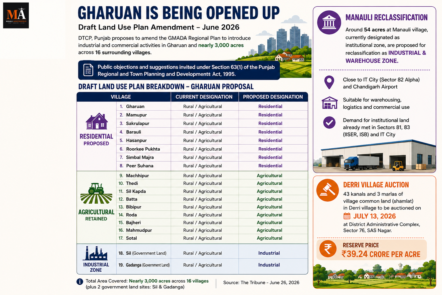
The Directorate of Town and Country Planning, Punjab, is set to amend the GMADA regional plan to introduce industrial and commercial activities in Gharuan and nearly 3,000 acres of land across 16 surrounding villages. The draft land use plan has been prepared by the Punjab Municipal Infrastructure Development Company and the DTCP, and public objections and suggestions are now being invited under Section 63(1) of the Punjab Regional and Town Planning and Development Act 1995.
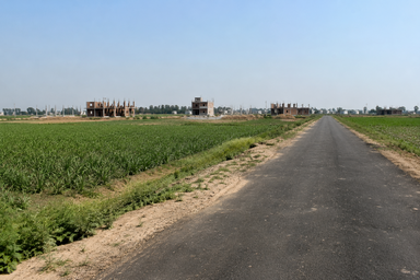
Gharuan is currently a Nagar Panchayat designated as rural and agricultural zone. Under that designation, only agricultural and a limited set of activities are permitted. The proposed amendment would change that — on the model of how SAS Nagar, New Chandigarh, Banur, Zirakpur, Dera Bassi, and Kharar were progressively opened up for urban development through notified master plans and land use plans. Gharuan would follow the same path.
Officials cited the specific trigger: Gharuan is facing tremendous pressure of development because of its proximity to Kharar. That pressure, currently unregulated under an agricultural zone designation, would be directed under the new land use framework.
What the Draft Plan Proposes
The 16-village footprint is divided by proposed land use.
Eight villages — Gharuan, Mamupur, Sakrulapur, Barauli, Hasanpur, Roorkee Pukhta, Simbal Majra, and Peer Suhana — are proposed to be designated as residential zones.
Nine villages — Machhipur, Thedi, Sil Kapda, Batta, Bibipur, Roda, Bajheri, Mahmudpur, and Sotal — are proposed as agricultural zones.
Government land in Sil and Gadanga villages is proposed as an industrial zone.
Why This Matters for the Kharar-Banur Belt
Gharuan sits in the growth corridor between Kharar and Banur, on the same belt that this month's coverage has returned to repeatedly: affordable residential demand, waterlogging on the Kharar-Landran road, sewage violations along national highway villages, and the active development pipeline of projects in Sectors 115, 124, and 127.
Opening 3,000 acres for industrial and commercial use in this corridor does two things simultaneously.
It creates employment within the belt. Industrial and commercial zones attract logistics companies, light manufacturing, warehousing, service businesses, and eventually retail — all of which generate jobs within the same geography where affordable residential supply is concentrated. That employment-to-housing proximity is the structural driver of sustained residential demand in any corridor.
It puts a planning framework around development that has been happening informally. The PPCB sewage violation cases, the borewell disposal complaints in Bhagomajra, the road restoration failures after PWSSB excavation — all of these reflect what happens when development pressure runs ahead of the planning and infrastructure framework governing it. A formal land use notification changes that: it triggers master plan obligations, infrastructure provisioning requirements, and regulatory coverage under the Punjab Regional and Town Planning Act.
The Manauli Reclassification
A separate amendment is also being processed for the Mohali Master Plan. Around 54 acres at Manauli village, currently designated as institutional zone, are being proposed for reclassification as industrial and warehouse zone.
The stated rationale is that the land is not suited for its current institutional designation in its present form. Officials noted that nearby Sectors 81 and 83 already carry sizeable institutional zones where IISER and ISB are established. IT City Sector 82 Alpha has land allotted for institutions, universities, and hospitals. The demand for more institutional land in this specific location has been met elsewhere.
Reclassifying 54 acres from institutional to industrial and warehouse in a location this close to IT City and Chandigarh airport is a specific commercial real estate signal. Warehousing and logistics near an airport and IT employment cluster generates consistent demand from cold chain operators, last-mile logistics companies, and commercial storage users. The reclassification makes that use permissible where it previously was not.
The Derri Village Auction
Separately, the Department of Rural Development and Panchayats has announced an auction of 43 kanals and 3 marlas of village common land in Derri village, to be held at the District Administrative Complex in Sector 76 on July 13. The reserve price has been fixed at Rs 39.24 crore per acre.
A reserve price of Rs 39.24 crore per acre for village common land indicates how far Derri's location has appreciated within the SAS Nagar district's land market. Village common land (shamlat) brought to auction at this price point confirms that even the peripheral village belts of Mohali are commanding institutional-grade land values.
---
Sources
- The Tribune — Gharuan set to be developed as industrial, commercial zone, June 26, 2026
घरुआण को विकसित किया जा रहा है
पंजाब के निदेशालय शहरी एवं ग्रामीण नियोजन (Directorate of Town and Country Planning, Punjab) घरुआण और इसके आसपास के 16 गांवों में लगभग 3,000 एकड़ भूमि पर औद्योगिक एवं वाणिज्यिक गतिविधियों को शुरू करने के लिए GMADA क्षेत्रीय योजना में संशोधन करने जा रहा है। ड्राफ्ट भू-उपयोग योजना पंजाब नगरपालिका बुनियादी ढांचा विकास कंपनी (Punjab Municipal Infrastructure Development Company) और DTCP द्वारा तैयार की गई है, और पंजाब क्षेत्रीय एवं नगर नियोजन और विकास अधिनियम 1995 (Punjab Regional and Town Planning and Development Act 1995) की धारा 63(1) के तहत अब सार्वजनिक आपत्तियां और सुझाव आमंत्रित किए जा रहे हैं।
घरुआण वर्तमान में एक नगर पंचायत है जिसे ग्रामीण एवं कृषि क्षेत्र के रूप में नामित किया गया है। इस पदनाम के तहत, केवल कृषि और कुछ सीमित गतिविधियों की अनुमति है। प्रस्तावित संशोधन इसे बदल देगा — उसी मॉडल पर जैसे SAS नगर, न्यू चंडीगढ़, बनूर, जीरकपुर, डेरा बस्सी और खरड़ को अधिसूचित मास्टर प्लान और भू-उपयोग योजनाओं के माध्यम से शहरी विकास के लिए खोला गया था। घरुआण भी उसी रास्ते पर चलेगा।
अधिकारियों ने विशिष्ट कारण बताया: खरड़ से निकटता के कारण घरुआण पर विकास का भारी दबाव है। यह दबाव, जो वर्तमान में कृषि क्षेत्र पदनाम के तहत अनियमित है, अब नई भू-उपयोग रूपरेखा के तहत निर्देशित किया जाएगा।
ड्राफ्ट योजना क्या प्रस्तावित करती है
16-गांवों का क्षेत्र प्रस्तावित भू-उपयोग के अनुसार विभाजित है।
आठ गांव — घरुआण, मामूपुर, सकरूलापुर, बरौली, हसनपुर, रुड़की पुख्ता, सिंबल माजरा और पीर सुहाना — को आवासीय क्षेत्र के रूप में नामित करने का प्रस्ताव है।
नौ गांव — मच्छीपुर, थेड़ी, सिल कपड़ा, बट्टा, बिबीपुर, रोडा, बजेरी, महमूदपुर और सोताल — को कृषि क्षेत्र के रूप में प्रस्तावित किया गया है।
सिल और गडांगा गांवों की सरकारी भूमि को औद्योगिक क्षेत्र के रूप में प्रस्तावित किया गया है।
खरड़-बनूर बेल्ट के लिए यह क्यों महत्वपूर्ण है
घरुआण खरड़ और बनूर के बीच विकास गलियारे में स्थित है, उसी बेल्ट पर जिस पर इस महीने की कवरेज बार-बार लौटी है: किफायती आवासीय मांग, खरड़-लंड्रां सड़क पर जलभराव, राष्ट्रीय राजमार्ग के गांवों के साथ सीवेज उल्लंघन, और सेक्टर 115, 124 और 127 में परियोजनाओं की सक्रिय विकास पाइपलाइन।
इस गलियारे में औद्योगिक और वाणिज्यिक उपयोग के लिए 3,000 एकड़ खोलना एक साथ दो काम करता है।
यह बेल्ट के भीतर रोजगार पैदा करता है। औद्योगिक और वाणिज्यिक क्षेत्र लॉजिस्टिक्स कंपनियों, हल्के विनिर्माण, भंडारण (warehousing), सेवा व्यवसायों और अंततः खुदरा (retail) को आकर्षित करते हैं — ये सभी उसी भौगोलिक क्षेत्र में नौकरियां पैदा करते हैं जहां किफायती आवासीय आपूर्ति केंद्रित है। रोजगार-से-आवास की यह निकटता किसी भी गलियारे में सतत आवासीय मांग का संरचनात्मक चालक है।
यह उस विकास के चारों ओर एक नियोजन ढांचा रखता है जो अनौपचारिक रूप से हो रहा है। PPCB के सीवेज उल्लंघन मामले, भगोमाजरा में बोरवेल निपटान शिकायतें, PWSSB उत्खनन के बाद सड़क बहाली में विफलताएं — ये सभी दर्शाते हैं कि जब विकास का दबाव योजना और बुनियादी ढांचा ढांचे से आगे हो जाता है तो क्या होता है। एक औपचारिक भू-उपयोग अधिसूचना इसे बदल देती है: यह मास्टर प्लान दायित्वों, बुनियादी ढांचा प्रावधान आवश्यकताओं और पंजाब क्षेत्रीय एवं नगर नियोजन अधिनियम (Punjab Regional and Town Planning Act) के तहत नियामक कवरेज को ट्रिगर करती है।
मनौली का पुनर्वर्गीकरण
एक अलग संशोधन मोहाली मास्टर प्लान के लिए भी संसाधित किया जा रहा है। मनौली गांव में लगभग 54 एकड़ भूमि, जो वर्तमान में संस्थागत क्षेत्र (institutional zone) के रूप में नामित है, को औद्योगिक और गोदाम क्षेत्र (industrial and warehouse zone) के रूप में पुनर्वर्गीकृत करने का प्रस्ताव है।
बताया गया तर्क यह है कि भूमि अपने वर्तमान स्वरूप में मौजूदा संस्थागत पदनाम के लिए उपयुक्त नहीं है। अधिकारियों ने कहा कि पास के सेक्टर 81 और 83 में पहले से ही बड़े संस्थागत क्षेत्र हैं जहां IISER और ISB स्थापित हैं। IT City सेक्टर 82 Alpha में संस्थानों, विश्वविद्यालयों और अस्पतालों के लिए भूमि आवंटित है। इस विशिष्ट स्थान पर अधिक संस्थागत भूमि की मांग अन्यत्र पूरी हो चुकी है।
IT City और चंडीगढ़ हवाई अड्डे के इतने करीब स्थान पर 54 एकड़ को संस्थागत से औद्योगिक और गोदाम में पुनर्वर्गीकृत करना एक विशिष्ट वाणिज्यिक रियल एस्टेट संकेत है। हवाई अड्डे और IT रोजगार क्लस्टर के पास भंडारण (warehousing) और लॉजिस्टिक्स कोल्ड चेन ऑपरेटरों, अंतिम-मील लॉजिस्टिक्स कंपनियों और वाणिज्यिक भंडारण उपयोगकर्ताओं से लगातार मांग उत्पन्न करता है। पुनर्वर्गीकरण उस उपयोग को अनुमेय बनाता है जहां यह पहले नहीं था।
देरी गांव की नीलामी
अलग से, विभाग ग्रामीण विकास एवं पंचायतों (Department of Rural Development and Panchayats) ने देरी गांव में 43 कनाल और 3 मरले ग्राम साझा भूमि (village common land) की नीलामी की घोषणा की है, जो 13 जुलाई को जिला प्रशासनिक परिसर (District Administrative Complex) सेक्टर 76 में आयोजित की जाएगी। आरक्षित मूल्य (reserve price) ₹39.24 करोड़ प्रति एकड़ निर्धारित किया गया है।
ग्राम साझा भूमि के लिए ₹39.24 करोड़ प्रति एकड़ का आरक्षित मूल्य यह दर्शाता है कि SAS नगर जिले के भूमि बाजार में देरी के स्थान ने कितनी सराहना की है। इस मूल्य बिंदु पर नीलामी के लिए लाई गई ग्राम साझा भूमि (शामलात) पुष्टि करती है कि मोहाली के परिधीय गांव बेल्ट भी संस्थागत-स्तर के भूमि मूल्यों का आदेश दे रहे हैं।
---
स्रोत
- The Tribune — Gharuan set to be developed as industrial, commercial zone, 26 जून, 2026
ਘੜੂੰਆ ਖੁੱਲ੍ਹ ਰਿਹਾ ਹੈ
ਪੰਜਾਬ ਦੇ ਟਾਊਨ ਐਂਡ ਕੰਟਰੀ ਪਲੈਨਿੰਗ ਵਿਭਾਗ (Directorate of Town and Country Planning, Punjab) GMADA ਖੇਤਰੀ ਯੋਜਨਾ ਵਿੱਚ ਸੋਧ ਕਰਨ ਜਾ ਰਿਹਾ ਹੈ ਤਾਂ ਜੋ ਘੜੂੰਆ ਅਤੇ ਆਲੇ-ਦੁਆਲੇ ਦੇ 16 ਪਿੰਡਾਂ ਵਿੱਚ ਲਗਭਗ 3,000 ਏਕੜ ਜ਼ਮੀਨ 'ਤੇ ਉਦਯੋਗਿਕ ਅਤੇ ਵਪਾਰਕ ਗਤੀਵਿਧੀਆਂ ਸ਼ੁਰੂ ਕੀਤੀਆਂ ਜਾ ਸਕਣ। ਡਰਾਫਟ ਭੂ-ਉਪਯੋਗ ਯੋਜਨਾ (draft land use plan) Punjab Municipal Infrastructure Development Company ਅਤੇ DTCP ਦੁਆਰਾ ਤਿਆਰ ਕੀਤੀ ਗਈ ਹੈ, ਅਤੇ Punjab Regional and Town Planning and Development Act 1995 ਦੀ ਧਾਰਾ 63(1) ਅਧੀਨ ਹੁਣ ਜਨਤਕ ਇਤਰਾਜ਼ ਅਤੇ ਸੁਝਾਅ ਮੰਗੇ ਜਾ ਰਹੇ ਹਨ।
ਘੜੂੰਆ ਵਰਤਮਾਨ ਵਿੱਚ ਇੱਕ Nagar Panchayat ਹੈ ਜਿਸਨੂੰ ਪੇਂਡੂ ਅਤੇ ਖੇਤੀਬਾੜੀ ਜ਼ੋਨ (rural and agricultural zone) ਵਜੋਂ ਨਿਰਧਾਰਤ ਕੀਤਾ ਗਿਆ ਹੈ। ਇਸ ਨਿਰਧਾਰਨ ਅਧੀਨ, ਸਿਰਫ ਖੇਤੀਬਾੜੀ ਅਤੇ ਸੀਮਤ ਗਤੀਵਿਧੀਆਂ ਦੀ ਇਜਾਜ਼ਤ ਹੈ। ਪ੍ਰਸਤਾਵਿਤ ਸੋਧ ਇਸਨੂੰ ਬਦਲ ਦੇਵੇਗੀ — ਉਸੇ ਮਾਡਲ 'ਤੇ ਜਿਵੇਂ SAS Nagar, New Chandigarh, Banur, Zirakpur, Dera Bassi, ਅਤੇ Kharar ਨੂੰ ਸੂਚਿਤ ਮਾਸਟਰ ਪਲਾਨਾਂ ਅਤੇ ਭੂ-ਉਪਯੋਗ ਯੋਜਨਾਵਾਂ (notified master plans and land use plans) ਰਾਹੀਂ ਹੌਲੀ-ਹੌਲੀ ਸ਼ਹਿਰੀ ਵਿਕਾਸ ਲਈ ਖੋਲ੍ਹਿਆ ਗਿਆ ਸੀ। ਘੜੂੰਆ ਵੀ ਇਸੇ ਰਸਤੇ 'ਤੇ ਚੱਲੇਗਾ।
ਅਧਿਕਾਰੀਆਂ ਨੇ ਖਾਸ ਕਾਰਨ ਦੱਸਿਆ: ਘੜੂੰਆ 'ਤੇ Kharar ਦੀ ਨੇੜਤਾ ਕਾਰਨ ਵਿਕਾਸ ਦਾ ਬਹੁਤ ਵੱਡਾ ਦਬਾਅ ਹੈ। ਇਹ ਦਬਾਅ, ਜੋ ਵਰਤਮਾਨ ਵਿੱਚ ਖੇਤੀਬਾੜੀ ਜ਼ੋਨ ਨਿਰਧਾਰਨ ਅਧੀਨ ਅਨਿਯੰਤ੍ਰਿਤ ਹੈ, ਨਵੇਂ ਭੂ-ਉਪਯੋਗ ਢਾਂਚੇ (land use framework) ਅਧੀਨ ਨਿਰਦੇਸ਼ਿਤ ਕੀਤਾ ਜਾਵੇਗਾ।
ਡਰਾਫਟ ਪਲਾਨ ਕੀ ਪ੍ਰਸਤਾਵਿਤ ਕਰਦਾ ਹੈ
16 ਪਿੰਡਾਂ ਦਾ ਘੇਰਾ ਪ੍ਰਸਤਾਵਿਤ ਭੂ-ਉਪਯੋਗ (proposed land use) ਅਧੀਨ ਵੰਡਿਆ ਗਿਆ ਹੈ।
ਅੱਠ ਪਿੰਡ — Gharuan, Mamupur, Sakrulapur, Barauli, Hasanpur, Roorkee Pukhta, Simbal Majra, ਅਤੇ Peer Suhana — ਨੂੰ ਰਿਹਾਇਸ਼ੀ ਜ਼ੋਨ (residential zones) ਵਜੋਂ ਨਿਰਧਾਰਤ ਕਰਨ ਦਾ ਪ੍ਰਸਤਾਵ ਹੈ।
ਨੌਂ ਪਿੰਡ — Machhipur, Thedi, Sil Kapda, Batta, Bibipur, Roda, Bajheri, Mahmudpur, ਅਤੇ Sotal — ਨੂੰ ਖੇਤੀਬਾੜੀ ਜ਼ੋਨ (agricultural zones) ਵਜੋਂ ਪ੍ਰਸਤਾਵਿਤ ਕੀਤਾ ਗਿਆ ਹੈ।
Sil ਅਤੇ Gadanga ਪਿੰਡਾਂ ਵਿੱਚ ਸਰਕਾਰੀ ਜ਼ਮੀਨ ਨੂੰ ਉਦਯੋਗਿਕ ਜ਼ੋਨ (industrial zone) ਵਜੋਂ ਪ੍ਰਸਤਾਵਿਤ ਕੀਤਾ ਗਿਆ ਹੈ।
Kharar-Banur ਬੈਲਟ ਲਈ ਇਹ ਕਿਉਂ ਮਹੱਤਵਪੂਰਨ ਹੈ
ਘੜੂੰਆ Kharar ਅਤੇ Banur ਵਿਚਕਾਰ ਵਿਕਾਸ ਕੋਰੀਡੋਰ (growth corridor) ਵਿੱਚ ਸਥਿਤ ਹੈ, ਉਸੇ ਬੈਲਟ 'ਤੇ ਜਿਸ 'ਤੇ ਇਸ ਮਹੀਨੇ ਦੀ ਕਵਰੇਜ ਵਾਰ-ਵਾਰ ਵਾਪਸ ਆਈ ਹੈ: ਕਿਫਾਇਤੀ ਰਿਹਾਇਸ਼ੀ ਮੰਗ (affordable residential demand), Kharar-Landran ਸੜਕ 'ਤੇ ਪਾਣੀ ਭਰਨਾ (waterlogging), ਰਾਸ਼ਟਰੀ ਮਾਰਗ ਪਿੰਡਾਂ ਦੇ ਨਾਲ ਸੀਵਰੇਜ ਉਲੰਘਣਾਵਾਂ (sewage violations), ਅਤੇ Sector 115, 124, ਅਤੇ 127 ਵਿੱਚ ਪ੍ਰੋਜੈਕਟਾਂ ਦੀ ਸਰਗਰਮ ਵਿਕਾਸ ਪਾਈਪਲਾਈਨ (active development pipeline)।
ਇਸ ਕੋਰੀਡੋਰ ਵਿੱਚ 3,000 ਏਕੜ ਨੂੰ ਉਦਯੋਗਿਕ ਅਤੇ ਵਪਾਰਕ ਵਰਤੋਂ ਲਈ ਖੋਲ੍ਹਣਾ ਇੱਕੋ ਸਮੇਂ ਦੋ ਕੰਮ ਕਰਦਾ ਹੈ।
ਇਹ ਬੈਲਟ ਦੇ ਅੰਦਰ ਰੁਜ਼ਗਾਰ ਪੈਦਾ ਕਰਦਾ ਹੈ। ਉਦਯੋਗਿਕ ਅਤੇ ਵਪਾਰਕ ਜ਼ੋਨ ਲੌਜਿਸਟਿਕਸ ਕੰਪਨੀਆਂ, ਹਲਕੇ ਨਿਰਮਾਣ (light manufacturing), ਵੇਅਰਹਾਊਸਿੰਗ (warehousing), ਸੇਵਾ ਕਾਰੋਬਾਰ (service businesses), ਅਤੇ ਅੰਤ ਵਿੱਚ ਪ੍ਰਚੂਨ (retail) ਨੂੰ ਆਕਰਸ਼ਿਤ ਕਰਦੇ ਹਨ — ਇਹ ਸਭ ਉਸੇ ਭੂਗੋਲ ਵਿੱਚ ਨੌਕਰੀਆਂ ਪੈਦਾ ਕਰਦੇ ਹਨ ਜਿੱਥੇ ਕਿਫਾਇਤੀ ਰਿਹਾਇਸ਼ੀ ਸਪਲਾਈ (affordable residential supply) ਕੇਂਦਰਿਤ ਹੈ। ਰੁਜ਼ਗਾਰ-ਤੋਂ-ਰਿਹਾਇਸ਼ ਨੇੜਤਾ (employment-to-housing proximity) ਕਿਸੇ ਵੀ ਕੋਰੀਡੋਰ ਵਿੱਚ ਟਿਕਾਊ ਰਿਹਾਇਸ਼ੀ ਮੰਗ (sustained residential demand) ਦਾ ਢਾਂਚਾਗਤ ਚਾਲਕ (structural driver) ਹੈ।
ਇਹ ਵਿਕਾਸ ਦੇ ਆਲੇ-ਦੁਆਲੇ ਇੱਕ ਯੋਜਨਾਬੰਦੀ ਢਾਂਚਾ (planning framework) ਰੱਖਦਾ ਹੈ ਜੋ ਅਨੌਪਚਾਰਿਕ ਤੌਰ 'ਤੇ ਹੋ ਰਿਹਾ ਹੈ। PPCB ਸੀਵਰੇਜ ਉਲੰਘਣਾ ਕੇਸ (sewage violation cases), Bhagomajra ਵਿੱਚ ਬੋਰਵੈੱਲ ਨਿਪਟਾਰੇ ਦੀਆਂ ਸ਼ਿਕਾਇਤਾਂ (borewell disposal complaints), PWSSB ਖੁਦਾਈ ਤੋਂ ਬਾਅਦ ਸੜਕ ਦੀ ਮੁਰੰਮਤ ਵਿੱਚ ਅਸਫਲਤਾਵਾਂ (road restoration failures) — ਇਹ ਸਭ ਉਸ ਸਥਿਤੀ ਨੂੰ ਦਰਸਾਉਂਦੇ ਹਨ ਜਦੋਂ ਵਿਕਾਸ ਦਬਾਅ (development pressure) ਯੋਜਨਾਬੰਦੀ ਅਤੇ ਬੁਨਿਆਦੀ ਢਾਂਚੇ ਦੇ ਢਾਂਚੇ (planning and infrastructure framework) ਤੋਂ ਅੱਗੇ ਵਧ ਜਾਂਦਾ ਹੈ ਜੋ ਇਸਨੂੰ ਨਿਯੰਤ੍ਰਿਤ ਕਰਦਾ ਹੈ। ਇੱਕ ਰਸਮੀ ਭੂ-ਉਪਯੋਗ ਸੂਚਨਾ (formal land use notification) ਇਸਨੂੰ ਬਦਲਦੀ ਹੈ: ਇਹ ਮਾਸਟਰ ਪਲਾਨ ਦੀਆਂ ਜ਼ਿੰਮੇਵਾਰੀਆਂ (master plan obligations), ਬੁਨਿਆਦੀ ਢਾਂਚੇ ਦੀ ਪ੍ਰਬੰਧ ਕਰਨ ਦੀਆਂ ਲੋੜਾਂ (infrastructure provisioning requirements), ਅਤੇ Punjab Regional and Town Planning Act ਅਧੀਨ ਰੈਗੂਲੇਟਰੀ ਕਵਰੇਜ (regulatory coverage) ਨੂੰ ਸ਼ੁਰੂ ਕਰਦੀ ਹੈ।
Manauli ਮੁੜ-ਵਰਗੀਕਰਨ
Mohali ਮਾਸਟਰ ਪਲਾਨ ਲਈ ਇੱਕ ਵੱਖਰੀ ਸੋਧ ਵੀ ਪ੍ਰਕਿਰਿਆ ਅਧੀਨ ਹੈ। Manauli ਪਿੰਡ ਵਿਖੇ ਲਗਭਗ 54 ਏਕੜ, ਜੋ ਵਰਤਮਾਨ ਵਿੱਚ ਸੰਸਥਾਗਤ ਜ਼ੋਨ (institutional zone) ਵਜੋਂ ਨਿਰਧਾਰਤ ਹੈ, ਨੂੰ ਉਦਯੋਗਿਕ ਅਤੇ ਵੇਅਰਹਾਊਸ ਜ਼ੋਨ (industrial and warehouse zone) ਵਜੋਂ ਮੁੜ-ਵਰਗੀਕਰਨ (reclassification) ਲਈ ਪ੍ਰਸਤਾਵਿਤ ਕੀਤਾ ਜਾ ਰਿਹਾ ਹੈ।
ਦੱਸਿਆ ਗਿਆ ਕਾਰਨ ਇਹ ਹੈ ਕਿ ਜ਼ਮੀਨ ਆਪਣੇ ਮੌਜੂਦਾ ਰੂਪ ਵਿੱਚ ਆਪਣੇ ਮੌਜੂਦਾ ਸੰਸਥਾਗਤ ਨਿਰਧਾਰਨ (current institutional designation) ਲਈ ਢੁਕਵੀਂ ਨਹੀਂ ਹੈ। ਅਧਿਕਾਰੀਆਂ ਨੇ ਨੋਟ ਕੀਤਾ ਕਿ ਨੇੜਲੇ Sector 81 ਅਤੇ 83 ਵਿੱਚ ਪਹਿਲਾਂ ਹੀ ਵੱਡੇ ਸੰਸਥਾਗਤ ਜ਼ੋਨ (sizeable institutional zones) ਹਨ ਜਿੱਥੇ IISER ਅਤੇ ISB ਸਥਾਪਿਤ ਹਨ। IT City Sector 82 Alpha ਵਿੱਚ ਸੰਸਥਾਵਾਂ, ਯੂਨੀਵਰਸਿਟੀਆਂ ਅਤੇ ਹਸਪਤਾਲਾਂ ਲਈ ਜ਼ਮੀਨ ਅਲਾਟ ਕੀਤੀ ਗਈ ਹੈ। ਇਸ ਖਾਸ ਸਥਾਨ 'ਤੇ ਹੋਰ ਸੰਸਥਾਗਤ ਜ਼ਮੀਨ ਦੀ ਮੰਗ ਹੋਰ ਥਾਵਾਂ 'ਤੇ ਪੂਰੀ ਕੀਤੀ ਗਈ ਹੈ।
IT City ਅਤੇ Chandigarh ਏਅਰਪੋਰਟ ਦੇ ਇੰਨੇ ਨੇੜੇ 54 ਏਕੜ ਨੂੰ ਸੰਸਥਾਗਤ ਤੋਂ ਉਦਯੋਗਿਕ ਅਤੇ ਵੇਅਰਹਾਊਸ ਵਿੱਚ ਮੁੜ-ਵਰਗੀਕਰਨ (reclassifying) ਕਰਨਾ ਇੱਕ ਖਾਸ ਵਪਾਰਕ ਰੀਅਲ ਅਸਟੇਟ ਸੰਕੇਤ (specific commercial real estate signal) ਹੈ। ਇੱਕ ਏਅਰਪੋਰਟ ਅਤੇ IT ਰੁਜ਼ਗਾਰ ਕਲੱਸਟਰ (IT employment cluster) ਦੇ ਨੇੜੇ ਵੇਅਰਹਾਊਸਿੰਗ ਅਤੇ ਲੌਜਿਸਟਿਕਸ (warehousing and logistics) ਕੋਲਡ ਚੇਨ ਓਪਰੇਟਰਾਂ (cold chain operators), ਲਾਸਟ-ਮਾਈਲ ਲੌਜਿਸਟਿਕਸ ਕੰਪਨੀਆਂ (last-mile logistics companies), ਅਤੇ ਵਪਾਰਕ ਸਟੋਰੇਜ ਉਪਭੋਗਤਾਵਾਂ (commercial storage users) ਤੋਂ ਲਗਾਤਾਰ ਮੰਗ ਪੈਦਾ ਕਰਦੀ ਹੈ। ਮੁੜ-ਵਰਗੀਕਰਨ ਇਸ ਵਰਤੋਂ ਨੂੰ ਉੱਥੇ ਜਾਇਜ਼ ਬਣਾਉਂਦਾ ਹੈ ਜਿੱਥੇ ਇਹ ਪਹਿਲਾਂ ਮਨਜ਼ੂਰ ਨਹੀਂ ਸੀ।
Derri ਪਿੰਡ ਦੀ ਨਿਲਾਮੀ
ਵੱਖਰੇ ਤੌਰ 'ਤੇ, ਪੇਂਡੂ ਵਿਕਾਸ ਅਤੇ ਪੰਚਾਇਤਾਂ ਵਿਭਾਗ (Department of Rural Development and Panchayats) ਨੇ Derri ਪਿੰਡ ਵਿੱਚ 43 ਕਨਾਲ ਅਤੇ 3 ਮਰਲੇ ਪਿੰਡ ਦੀ ਸਾਂਝੀ ਜ਼ਮੀਨ (village common land) ਦੀ ਨਿਲਾਮੀ (auction) ਦਾ ਐਲਾਨ ਕੀਤਾ ਹੈ, ਜੋ 13 ਜੁਲਾਈ ਨੂੰ Sector 76 ਵਿੱਚ District Administrative Complex ਵਿੱਚ ਹੋਵੇਗੀ। ਰਿਜ਼ਰਵ ਮੁੱਲ (reserve price) Rs 39.24 ਕਰੋੜ ਪ੍ਰਤੀ ਏਕੜ ਤੈਅ ਕੀਤਾ ਗਿਆ ਹੈ।
Rs 39.24 ਕਰੋੜ ਪ੍ਰਤੀ ਏਕੜ ਦਾ ਰਿਜ਼ਰਵ ਮੁੱਲ (reserve price) ਪਿੰਡ ਦੀ ਸਾਂਝੀ ਜ਼ਮੀਨ (village common land (shamlat)) ਲਈ Derri ਦੇ ਸਥਾਨ ਨੇ SAS Nagar ਜ਼ਿਲ੍ਹੇ ਦੇ ਜ਼ਮੀਨ ਬਾਜ਼ਾਰ (land market) ਵਿੱਚ ਕਿੰਨੀ ਕਦਰ (appreciation) ਕੀਤੀ ਹੈ, ਇਸ ਨੂੰ ਦਰਸਾਉਂਦਾ ਹੈ। ਇਸ ਕੀਮਤ ਬਿੰਦੂ (price point) 'ਤੇ ਨਿਲਾਮੀ ਲਈ ਲਿਆਂਦੀ ਗਈ ਪਿੰਡ ਦੀ ਸਾਂਝੀ ਜ਼ਮੀਨ (village common land (shamlat)) ਇਸ ਗੱਲ ਦੀ ਪੁਸ਼ਟੀ ਕਰਦੀ ਹੈ ਕਿ Mohali ਦੇ ਪੈਰੀਫਿਰਲ ਪਿੰਡ ਬੈਲਟ (peripheral village belts) ਵੀ ਸੰਸਥਾਗਤ-ਗਰੇਡ ਜ਼ਮੀਨ ਮੁੱਲ (institutional-grade land values) ਦਾ ਹੁਕਮ ਦੇ ਰਹੇ ਹਨ।
---
ਸਰੋਤ
- The Tribune — Gharuan set to be developed as industrial, commercial zone, June 26, 2026