
Lalru Master Plan: Zones, CLU and What to Check Before Buying
The Plan Comes Before the Price
Lalru is planned as one of Punjab's major industrial and logistics hubs, with industrial land accounting for about 41% of the proposed land use. Understanding the Master Plan helps buyers identify where residential development is permitted and where additional approvals, such as CLU, may be required.
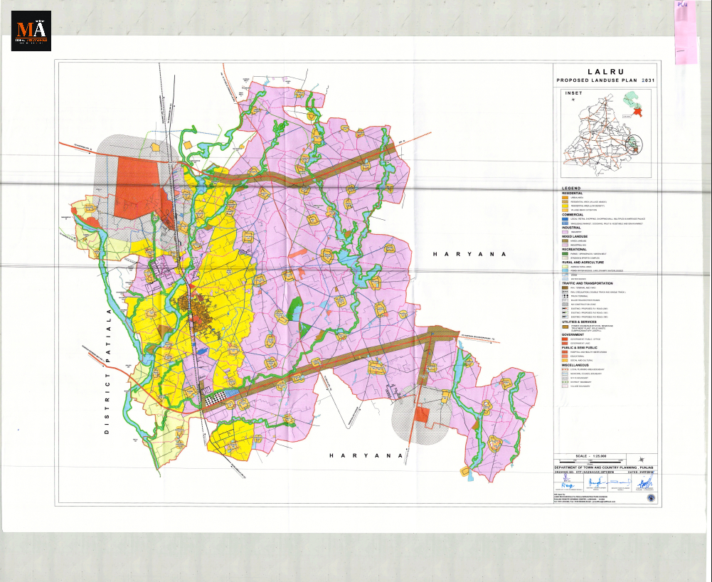
The Lalru Land Use Plan is notified and available at gmada.gov.in and puda.punjab.gov.in. Its existing land use is recorded in Drawing No. DTP(SAS Nagar) 2249/2015 dated December 7, 2015, and its proposed land use in Drawing No. DTP(SAS Nagar) 2271/2016 dated July 21, 2016. The plan covers 2 towns and 75 villages across 22,429 hectares in SAS Nagar district. It is prepared under the Punjab Regional and Town Planning and Development Act, 1995 and governs development across the Lalru Local Planning Area, with a planning horizon to 2031.
The Zone Structure
The Lalru plan does not use the R1 to R4 zone classification found in the Kharar and Dera Bassi plans. It uses descriptive zone names. The full proposed land use table is:
Industrial: 9,199 hectares (41.01%) — the dominant designation. All heavy, red, and orange category industries as per PPCB guidelines are permissible, alongside IT parks, business parks, knowledge parks, science parks, logistics parks, pharmaceutical and chemical parks, cold stores, warehouses, hotels, hospitals, ITI and technical institutes, and industrial labour quarters.
Rural and Agricultural: 6,601 hectares (29.43%) — the largest non-industrial designation. Agro-technology parks, aquaculture farms, plant nurseries, and all agricultural activities are permissible. No residential or commercial development without a formal CLU.
Residential: 3,090 hectares (13.78%) — residential flats, group housing, apartments, townhouses, and semi-detached houses. Commercial uses are allowed within residential areas if on roads with minimum 60-foot ROW. Stand-alone commercial complexes above double storey require an 80-foot road, minimum 1,000 sqm plot, and maximum 40 percent ground coverage. Minimum plotted colony: 10 acres. Minimum group housing (general): 2 acres.
No Construction Zone: 1,551 hectares (6.91%) — areas along water bodies and seasonal channels where construction is prohibited. This is a significant designation in Lalru given the choes (seasonal streams) that criss-cross the LPA.
Industrial and Mix: 1,477 hectares (6.59%) — green category industries only (as per PPCB), alongside plotted residential, group housing, institutions, hospitals, and hotels.
Mixed Land Use: 257 hectares (1.15%) — educational, institutional, and residential uses alongside green category industry and hotels.
Recreational: 147 hectares (0.66%) — sports complexes, indoor stadiums, swimming complexes, golf courses, theme parks, and recreation clubs.
Commercial: 13 hectares (0.05%) — the smallest designated zone. Commercial facilities in Lalru are primarily subsumed under residential land use rather than separately demarcated.
Source: Land Use Plan Lalru report, Table: Break up of Major Proposed Land Uses, PRSC, PAU, Ludhiana; Drawing No. DTP(SAS Nagar) 2271/2016 dated 21.07.2016.
The Road Hierarchy
The Lalru plan confirms the following road designations with right-of-way widths. All primary roads carry a 30-metre no-construction zone on each side beyond the ROW:
| Road | ROW | No-construction zone each side |
|---|---|---|
| NH-22 (Chandigarh-Ambala, old numbering) | 60m (200ft) | 30m |
| Proposed PR-1 (GMADA Expressway) | 60m (200ft) | 30m |
| Proposed PR-8 | 60m (200ft) | 30m |
| Proposed PR-10 | 60m (200ft) | 30m |
| Existing link roads | To be widened to 40 feet | — |
PR-1 enters the Lalru LPA from the southern boundary of the Banur Master Plan. PR-8 enters from the southern boundary of the Derabassi Master Plan. PR-10 runs generally southward from Panchkula Sector 20 along an alignment east of and parallel to NH-22 toward the GMADA Expressway.
A truck terminal is proposed on PR-1. A dry port is proposed along NH-22 and the railway line for logistics movement. Source: Land Use Plan Lalru, Chapter 6, Proposed Road Hierarchy, Table Proposed Road Network.
Lalru's Role in the GMADA Region
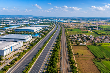
Lalru is not a satellite residential town. The plan's stated vision is to develop it into a planned industrial hub, and it names three growth poles: pharmaceuticals and chemicals, high-technology and IT, and a logistics hub built around the existing railway. The industrial zone permits red, orange and general categories as per PPCB guidelines.
The industries already established in the LPA confirm this character: Nahar Processing Industry, Gates Hydrolix, JCBL, MSL Ltd., Khandelwal Forgings, Punjab Chemicals, Agro-Duch Industry, Nutrica, Rana Polycot, and others have been operating here for years. The LPA also has one of the biggest chilli markets in the region.
The Chandigarh-Ambala-Delhi railway line passes through Lalru, and the plan explicitly proposes a logistics hub to capitalise on this rail infrastructure for movement of industrial goods.
The Ambala to IT City Greenfield Expressway, around 89 percent complete and targeted for October 2026, runs through this belt. Once operational, it compresses travel time between Lalru and Mohali's IT City, improving Lalru's position within the Tricity employment network for both workers and industrial logistics.
Planning and Regulatory Framework
Punjab Regional and Town Planning and Development Act, 1995
The Lalru plan is prepared under this Act. Section 69 of the Act provides no direct demolition power for Regional Plan violations. The enforcement route for violations is notices to the violator, then FIRs through the SSP if the notices are not complied with. This is different from demolition orders.
Punjab New Capital (Periphery) Control Act, 1952
Parts of the Lalru LPA may fall within Chandigarh's controlled periphery. Whether your specific parcel falls within the notified boundary must be confirmed with a registered property advocate.
The Choes: A Constraint Unique to Lalru
Choes are seasonal water channels that criss-cross the Lalru region. The plan establishes mandatory green strip requirements on both sides:
- Minor choes: minimum 15 metres green strip on each side, no construction permitted in the strip
- Major choes: minimum 30 metres green strip on each side, no construction permitted
In these green strips, golf courses, sports, and recreational activities are permitted, but no construction of any kind is allowed. Support facilities must be placed outside the strips.
The plan designates 1,551 hectares as No Construction Zone, covering water-body and channel adjacency. If your plot is near a choe, part of your land may fall within a legally mandated no-construction strip that directly reduces your buildable area. Verify this against the plan map before any purchase.
The Ghaggar River
The Ghaggar River forms the western boundary of the Lalru LPA. A river reserve and green belt designation applies to the river frontage. The plan notes the vision of safeguarding valuable river-frontage land for premium residential uses, but the green belt restrictions must be verified against the plan map for any specific parcel near the river.
The Ammunition Dump
Three villages, Dapper, Bair Majra, and Nagla, contain an ammunition dump. The plan explicitly states that requisite guidelines and notifications from the concerned ministry regarding defence lands shall apply irrespective of the land use shown on the plan. Any land near these villages requires confirmation of defence ministry guidelines before any development or purchase decision.
Unauthorised Colonies
GMADA publishes a list of plots that have received NOCs under its regularisation policy at gmada.gov.in. Verify your specific colony against this list. Do not assume regularisation status in either direction, since some colonies have received NOCs and some have not.
Infrastructure That Could Influence Lalru
No forecast is made here. These are confirmed public-record events:
October 2026: The Ambala to IT City Greenfield Expressway completes. This changes Lalru's drive time to Mohali's IT City and the airport corridor.
July 17, 2026: PM Modi laid the foundation stone of the Zirakpur-Panchkula bypass, a 19.2-km, six-lane project that, when complete, routes long-distance traffic away from the NH-5 and Zirakpur corridor, affecting regional connectivity across the Dera Bassi, Lalru and Banur belt.
A plan says what is permitted. A notice says what is coming. Both are public at gmada.gov.in. Everything else is an opinion.
What to Check Before Buying in Lalru
- Open the Lalru Land Use Plan on gmada.gov.in or puda.punjab.gov.in and locate your survey number on the zone map
- Confirm the zone designation: Industrial, Industrial-Mix, Residential, Mixed Land Use, Agricultural, or No Construction Zone
- If the land is in Agricultural or Rural zone, confirm a CLU has been granted, not just applied for, and verify it at GMADA's Town and Country Planning office
- Check for choe proximity: minor choes carry a 15m no-construction strip on each side, major choes carry 30m. Verify whether your plot's buildable area is affected
- Check whether the plot is near Dapper, Bair Majra, or Nagla villages where the ammunition dump is located, since defence ministry rules apply regardless of the plan
- Verify whether your plot falls in the No Construction Zone, where water-body and choe adjacency is the primary reason
- Check GMADA's NOC regularisation list at gmada.gov.in for your specific colony
- Confirm Periphery Control Act applicability for your parcel with a registered property advocate
- Commission a title search from a registered property advocate tracing the jamabandi from original owner to current seller
---
Sources
- GMADA, Land Use Plan Lalru Report (Report_of_Lalru.pdf), gmada.gov.in
- GMADA, Master Plan Lalru, proposed land use Drawing No. DTP(SAS Nagar) 2271/2016 dated 21.07.2016; existing land use Drawing No. DTP(SAS Nagar) 2249/2015 dated 07.12.2015
- PUDA, Lalru Master Plan, puda.punjab.gov.in
- GMADA, NOC regularisation list, gmada.gov.in
- Punjab Regional and Town Planning and Development Act, 1995, Section 69 and Section 70
- Punjab New Capital (Periphery) Control Act, 1952
- Mohali Aerotropolis, Dera Bassi Master Plan, GMADA enforcement, Tricity infrastructure calendar coverage, July 2026
Lalru Master Plan: Zones, CLU and What to Check Before Buying
योजना कीमत से पहले आती है
लालरू को पंजाब के प्रमुख औद्योगिक और लॉजिस्टिक्स हब के रूप में योजनाबद्ध किया गया है, जिसमें लगभग 41% प्रस्तावित भू-उपयोग औद्योगिक भूमि का है। मास्टर प्लान को समझने से खरीदारों को यह पहचानने में मदद मिलती है कि आवासीय विकास कहाँ अनुमत है और कहाँ अतिरिक्त अनुमोदन, जैसे CLU, की आवश्यकता हो सकती है।
लालरू भू-उपयोग योजना अधिसूचित है और gmada.gov.in तथा puda.punjab.gov.in पर उपलब्ध है। इसका मौजूदा भू-उपयोग दिनांक 7 दिसंबर, 2015 के ड्राइंग नं. DTP(SAS Nagar) 2249/2015 में दर्ज है, और इसका प्रस्तावित भू-उपयोग दिनांक 21 जुलाई, 2016 के ड्राइंग नं. DTP(SAS Nagar) 2271/2016 में दर्ज है। यह योजना SAS Nagar जिले के 22,429 हेक्टेयर क्षेत्र में 2 कस्बों और 75 गांवों को कवर करती है। इसे पंजाब क्षेत्रीय और नगर नियोजन और विकास अधिनियम, 1995 के तहत तैयार किया गया है और यह लालरू स्थानीय नियोजन क्षेत्र में विकास को नियंत्रित करती है, जिसकी नियोजन क्षितिज 2031 तक है।
ज़ोन संरचना
लालरू योजना में खरड़ और डेरा बस्सी योजनाओं में पाए जाने वाले R1 से R4 ज़ोन वर्गीकरण का उपयोग नहीं किया गया है। यह वर्णनात्मक ज़ोन नामों का उपयोग करती है। पूर्ण प्रस्तावित भू-उपयोग तालिका इस प्रकार है:
औद्योगिक: 9,199 हेक्टेयर (41.01%) — प्रमुख पदनाम। PPCB दिशानिर्देशों के अनुसार सभी भारी, लाल और नारंगी श्रेणी के उद्योग अनुमत हैं, साथ ही IT पार्क, व्यवसाय पार्क, नॉलेज पार्क, साइंस पार्क, लॉजिस्टिक्स पार्क, फार्मास्युटिकल और केमिकल पार्क, कोल्ड स्टोर, गोदाम, होटल, अस्पताल, ITI और तकनीकी संस्थान, और औद्योगिक श्रमिक क्वार्टर भी अनुमत हैं।
ग्रामीण और कृषि: 6,601 हेक्टेयर (29.43%) — सबसे बड़ा गैर-औद्योगिक पदनाम। कृषि-प्रौद्योगिकी पार्क, जलीय कृषि फार्म, पौध नर्सरी, और सभी कृषि गतिविधियाँ अनुमत हैं। औपचारिक CLU के बिना कोई आवासीय या वाणिज्यिक विकास नहीं।
आवासीय: 3,090 हेक्टेयर (13.78%) — आवासीय फ्लैट, ग्रुप हाउसिंग, अपार्टमेंट, टाउनहाउस, और अर्ध-पृथक घर। आवासीय क्षेत्रों के भीतर वाणिज्यिक उपयोग की अनुमति है यदि वे न्यूनतम 60 फीट ROW वाली सड़कों पर हों। दो मंजिल से ऊपर के स्वतंत्र वाणिज्यिक परिसरों के लिए 80 फीट की सड़क, न्यूनतम 1,000 वर्ग मीटर का प्लॉट, और अधिकतम 40 प्रतिशत ग्राउंड कवरेज आवश्यक है। न्यूनतम प्लॉटेड कॉलोनी: 10 एकड़। न्यूनतम ग्रुप हाउसिंग (सामान्य): 2 एकड़।
नो कंस्ट्रक्शन ज़ोन: 1,551 हेक्टेयर (6.91%) — जल निकायों और मौसमी चैनलों के साथ के क्षेत्र जहाँ निर्माण निषिद्ध है। LPA को पार करने वाले चो (मौसमी नालों) को देखते हुए लालरू में यह एक महत्वपूर्ण पदनाम है।
औद्योगिक और मिश्रित: 1,477 हेक्टेयर (6.59%) — केवल हरित श्रेणी के उद्योग (PPCB के अनुसार), साथ ही प्लॉटेड आवासीय, ग्रुप हाउसिंग, संस्थान, अस्पताल, और होटल।
मिश्रित भू-उपयोग: 257 हेक्टेयर (1.15%) — हरित श्रेणी के उद्योग और होटलों के साथ शैक्षिक, संस्थागत, और आवासीय उपयोग।
मनोरंजक: 147 हेक्टेयर (0.66%) — खेल परिसर, इनडोर स्टेडियम, स्विमिंग कॉम्प्लेक्स, गोल्फ कोर्स, थीम पार्क, और मनोरंजन क्लब।
वाणिज्यिक: 13 हेक्टेयर (0.05%) — सबसे छोटा निर्दिष्ट क्षेत्र। लालरू में वाणिज्यिक सुविधाएँ मुख्य रूप से अलग से सीमांकित होने के बजाय आवासीय भू-उपयोग के अंतर्गत शामिल की गई हैं।
स्रोत: भू-उपयोग योजना लालरू रिपोर्ट, तालिका: प्रमुख प्रस्तावित भू-उपयोगों का विवरण, PRSC, PAU, लुधियाना; ड्राइंग नं. DTP(SAS Nagar) 2271/2016 दिनांक 21.07.2016।
सड़क पदानुक्रम
लालरू योजना ROW चौड़ाई के साथ निम्नलिखित सड़क पदनामों की पुष्टि करती है। सभी प्राथमिक सड़कों पर ROW से परे प्रत्येक तरफ 30 मीटर का नो-कंस्ट्रक्शन ज़ोन है:
| सड़क | ROW | प्रत्येक तरफ नो-कंस्ट्रक्शन ज़ोन |
|---|---|---|
| NH-22 (चंडीगढ़-अंबाला, पुरानी नंबरिंग) | 60m (200ft) | 30m |
| प्रस्तावित PR-1 (GMADA एक्सप्रेसवे) | 60m (200ft) | 30m |
| प्रस्तावित PR-8 | 60m (200ft) | 30m |
| प्रस्तावित PR-10 | 60m (200ft) | 30m |
| मौजूदा लिंक रोड | 40 फीट तक चौड़ा किया जाना है | — |
PR-1, बनूर मास्टर प्लान की दक्षिणी सीमा से लालरू LPA में प्रवेश करता है। PR-8, डेराबस्सी मास्टर प्लान की दक्षिणी सीमा से प्रवेश करता है। PR-10, पंचकूला सेक्टर 20 से आम तौर पर दक्षिण की ओर NH-22 के पूर्व में और समानांतर एक संरेखण के साथ GMADA एक्सप्रेसवे की ओर जाता है।
PR-1 पर एक ट्रक टर्मिनल प्रस्तावित है। लॉजिस्टिक्स आवाजाही के लिए NH-22 और रेलवे लाइन के साथ एक ड्राई पोर्ट प्रस्तावित है। स्रोत: भू-उपयोग योजना लालरू, अध्याय 6, प्रस्तावित सड़क पदानुक्रम, तालिका प्रस्तावित सड़क नेटवर्क।
GMADA क्षेत्र में लालरू की भूमिका
लालरू एक उपग्रह आवासीय शहर नहीं है। योजना का कथित दृष्टिकोण इसे एक नियोजित औद्योगिक केंद्र के रूप में विकसित करना है, और यह तीन विकास ध्रुवों का नाम देती है: फार्मास्यूटिकल्स और केमिकल्स, उच्च-प्रौद्योगिकी और IT, और मौजूदा रेलवे के आसपास बना एक लॉजिस्टिक्स हब। औद्योगिक क्षेत्र PPCB दिशानिर्देशों के अनुसार लाल, नारंगी और सामान्य श्रेणियों की अनुमति देता है।
LPA में पहले से स्थापित उद्योग इस चरित्र की पुष्टि करते हैं: नाहर प्रोसेसिंग इंडस्ट्री, गेट्स हाइड्रोलिक्स, JCBL, MSL Ltd., खंडेलवाल फोर्जिंग्स, पंजाब केमिकल्स, एग्रो-डच इंडस्ट्री, न्यूट्रिका, राणा पॉलीकॉट, और अन्य वर्षों से यहाँ काम कर रहे हैं। LPA में क्षेत्र के सबसे बड़े मिर्च बाजारों में से एक भी है।
चंडीगढ़-अंबाला-दिल्ली रेलवे लाइन लालरू से होकर गुजरती है, और योजना स्पष्ट रूप से औद्योगिक वस्तुओं की आवाजाही के लिए इस रेल बुनियादी ढांचे का लाभ उठाने के लिए एक लॉजिस्टिक्स हब का प्रस्ताव करती है।
अंबाला से IT City ग्रीनफील्ड एक्सप्रेसवे, जो लगभग 89 प्रतिशत पूरा हो चुका है और अक्टूबर 2026 के लिए लक्षित है, इस बेल्ट से होकर गुजरता है। एक बार चालू होने पर, यह लालरू और मोहाली के IT City के बीच यात्रा समय को कम करता है, जिससे श्रमिकों और औद्योगिक लॉजिस्टिक्स दोनों के लिए त्रिशहरी रोजगार नेटवर्क में लालरू की स्थिति में सुधार होता है।
नियोजन और नियामक ढाँचा
पंजाब क्षेत्रीय और नगर नियोजन और विकास अधिनियम, 1995
लालरू योजना इस अधिनियम के तहत तैयार की गई है। अधिनियम की धारा 69 क्षेत्रीय योजना उल्लंघनों के लिए प्रत्यक्ष विध्वंस शक्ति प्रदान नहीं करती है। उल्लंघनों के लिए प्रवर्तन का मार्ग उल्लंघनकर्ता को नोटिस जारी करना है, फिर यदि नोटिसों का अनुपालन नहीं किया जाता है तो SSP के माध्यम से FIR दर्ज करना है। यह विध्वंस आदेशों से भिन्न है।
पंजाब न्यू कैपिटल (पेरिफेरी) कंट्रोल एक्ट, 1952
लालरू LPA के कुछ हिस्से चंडीगढ़ के नियंत्रित परिधि के अंतर्गत आ सकते हैं। आपका विशिष्ट पार्सल अधिसूचित सीमा के अंतर्गत आता है या नहीं, इसकी पुष्टि एक पंजीकृत संपत्ति अधिवक्ता से की जानी चाहिए।
चो: लालरू के लिए अद्वितीय एक बाधा
चो मौसमी जल चैनल हैं जो लालरू क्षेत्र में कहीं भी पाए जाते हैं। योजना दोनों तरफ अनिवार्य हरित पट्टी आवश्यकताएँ स्थापित करती है:
- लघु चो: प्रत्येक तरफ न्यूनतम 15 मीटर हरित पट्टी, पट्टी में कोई निर्माण अनुमत नहीं
- प्रमुख चो: प्रत्येक तरफ न्यूनतम 30 मीटर हरित पट्टी, कोई निर्माण अनुमत नहीं
इन हरित पट्टियों में, गोल्फ कोर्स, खेल और मनोरंजक गतिविधियाँ अनुमत हैं, लेकिन किसी भी प्रकार के निर्माण की अनुमति नहीं है। सहायक सुविधाओं को पट्टियों के बाहर रखा जाना चाहिए।
योजना 1,551 हेक्टेयर को नो कंस्ट्रक्शन ज़ोन के रूप में नामित करती है, जो जल-निकाय और चैनल से सटे क्षेत्रों को कवर करती है। यदि आपका प्लॉट किसी चो के पास है, तो आपकी भूमि का एक हिस्सा कानूनी रूप से अनिवार्य नो-कंस्ट्रक्शन पट्टी के अंतर्गत आ सकता है जो सीधे आपके निर्माण योग्य क्षेत्र को कम करता है। किसी भी खरीद से पहले योजना मानचित्र के विरुद्ध इसकी पुष्टि करें।
घग्गर नदी
घग्गर नदी लालरू LPA की पश्चिमी सीमा बनाती है। नदी के सामने के भाग के लिए एक नदी आरक्षित और हरित पेटी पदनाम लागू होता है। योजना प्रीमियम आवासीय उपयोगों के लिए मूल्यवान नदी-सामने की भूमि की सुरक्षा की दृष्टि पर ध्यान देती है, लेकिन नदी के पास किसी विशिष्ट पार्सल के लिए योजना मानचित्र के विरुद्ध हरित पेटी प्रतिबंधों की पुष्टि की जानी चाहिए।
गोला-बारूद डंप
तीन गाँव, डप्पर, बैर माजरा, और नागला, में एक गोला-बारूद डंप है। योजना स्पष्ट रूप से बताती है कि रक्षा भूमि से संबंधित संबंधित मंत्रालय के आवश्यक दिशानिर्देश और अधिसूचनाएँ योजना पर दिखाए गए भू-उपयोग के बावजूद लागू होंगी। किसी भी विकास या खरीद निर्णय से पहले इन गाँवों के पास किसी भी भूमि के लिए रक्षा मंत्रालय के दिशानिर्देशों की पुष्टि आवश्यक है।
अनाधिकृत कॉलोनियाँ
GMADA अपनी नियमितीकरण नीति के तहत NOC प्राप्त करने वाले प्लॉटों की एक सूची gmada.gov.in पर प्रकाशित करता है। अपनी विशिष्ट कॉलोनी को इस सूची के विरुद्ध सत्यापित करें। किसी भी दिशा में नियमितीकरण की स्थिति न मानें, क्योंकि कुछ कॉलोनियों को NOC प्राप्त हुए हैं और कुछ को नहीं।
बुनियादी ढाँचा जो लालरू को प्रभावित कर सकता है
यहाँ कोई पूर्वानुमान नहीं लगाया गया है। ये पुष्टि किए गए सार्वजनिक रिकॉर्ड की घटनाएँ हैं:
अक्टूबर 2026: अंबाला से IT City ग्रीनफील्ड एक्सप्रेसवे पूरा होता है। यह लालरू से मोहाली के IT City और एयरपोर्ट कॉरिडोर के ड्राइव समय को बदलता है।
17 जुलाई, 2026: पीएम मोदी ने ज़ीरकपुर-पंचकूला बाईपास की आधारशिला रखी, जो 19.2 किमी का छह-लेन परियोजना है, जो पूरा होने पर लंबी दूरी के यातायात को NH-5 और ज़ीरकपुर कॉरिडोर से दूर मोड़ देगी, जो डेरा बस्सी, लालरू और बनूर बेल्ट में क्षेत्रीय कनेक्टिविटी को प्रभावित करेगी।
एक योजना बताती है कि क्या अनुमत है। एक नोटिस बताता है कि क्या आने वाला है। दोनों gmada.gov.in पर सार्वजनिक हैं। बाकी सब कुछ एक राय है।
लालरू में खरीदने से पहले क्या जाँचें
- gmada.gov.in या puda.punjab.gov.in पर लालरू भू-उपयोग योजना खोलें और ज़ोन मानचित्र पर अपना सर्वे नंबर ढूँढें
- ज़ोन पदनाम की पुष्टि करें: औद्योगिक, औद्योगिक-मिश्रित, आवासीय, मिश्रित भू-उपयोग, कृषि, या नो कंस्ट्रक्शन ज़ोन
- यदि भूमि कृषि या ग्रामीण क्षेत्र में है, तो पुष्टि करें कि CLU प्रदान किया गया है, न कि केवल आवेदन किया गया है, और इसे GMADA के नगर और देश नियोजन कार्यालय में सत्यापित करें
- चो निकटता की जाँच करें: लघु चो पर प्रत्येक तरफ 15 मीटर का नो-कंस्ट्रक्शन स्ट्रिप होता है, प्रमुख चो पर 30 मीटर। सत्यापित करें कि आपके प्लॉट का निर्माण योग्य क्षेत्र प्रभावित है या नहीं
- जाँच करें कि क्या प्लॉट डप्पर, बैर माजरा, या नागला गाँवों के पास है जहाँ गोला-बारूद डंप स्थित है, क्योंकि योजना के बावजूद रक्षा मंत्रालय के नियम लागू होते हैं
- सत्यापित करें कि क्या आपका प्लॉट नो कंस्ट्रक्शन ज़ोन में आता है, जहाँ जल-निकाय और चो से सटे होना प्राथमिक कारण है
- GMADA की NOC नियमितीकरण सूची gmada.gov.in पर अपनी विशिष्ट कॉलोनी के लिए जाँचें
- एक पंजीकृत संपत्ति अधिवक्ता से अपने पार्सल के लिए परिधि नियंत्रण अधिनियम की प्रयोज्यता की पुष्टि करें
- एक पंजीकृत संपत्ति अधिवक्ता से शीर्षक खोज का आदेश दें जो मूल मालिक से वर्तमान विक्रेता तक जमाबंदी का पता लगाए
---
स्रोत
- GMADA, भू-उपयोग योजना लालरू रिपोर्ट (Report_of_Lalru.pdf), gmada.gov.in
- GMADA, मास्टर प्लान लालरू, प्रस्तावित भू-उपयोग ड्राइंग नं. DTP(SAS Nagar) 2271/2016 दिनांक 21.07.2016; मौजूदा भू-उपयोग ड्राइंग नं. DTP(SAS Nagar) 2249/2015 दिनांक 07.12.2015
- PUDA, लालरू मास्टर प्लान, puda.punjab.gov.in
- GMADA, NOC नियमितीकरण सूची, gmada.gov.in
- पंजाब क्षेत्रीय और नगर नियोजन और विकास अधिनियम, 1995, धारा 69 और धारा 70
- पंजाब न्यू कैपिटल (पेरिफेरी) कंट्रोल एक्ट, 1952
- मोहाली एरोट्रोपोलिस, डेरा बस्सी मास्टर प्लान, GMADA प्रवर्तन, त्रिशहरी बुनियादी ढाँचा कैलेंडर कवरेज, जुलाई 2026
ਲਾਲੜੂ ਮਾਸਟਰ ਪਲੈਨ: ਜ਼ੋਨ, CLU ਅਤੇ ਖਰੀਦਣ ਤੋਂ ਪਹਿਲਾਂ ਕੀ ਜਾਂਚ ਕਰਨਾ ਚਾਹੀਦਾ ਹੈ
ਪਲੈਨ ਕੀਮਤ ਤੋਂ ਪਹਿਲਾਂ ਆਉਂਦਾ ਹੈ
ਲਾਲੜੂ ਨੂੰ ਪੰਜਾਬ ਦੇ ਪ੍ਰਮੁੱਖ ਉਦਯੋਗਿਕ ਅਤੇ ਲੌਜਿਸਟਿਕ ਹੱਬਾਂ ਵਿੱਚੋਂ ਇੱਕ ਵਜੋਂ ਯੋਜਨਾਬੱਧ ਕੀਤਾ ਗਿਆ ਹੈ, ਜਿਸ ਵਿੱਚ ਪ੍ਰਸਤਾਵਿਤ ਭੂ-ਉਪਯੋਗ ਦਾ ਲਗਭਗ 41% ਉਦਯੋਗਿਕ ਜ਼ਮੀਨ ਹੈ। ਮਾਸਟਰ ਪਲੈਨ ਨੂੰ ਸਮਝਣ ਨਾਲ ਖਰੀਦਦਾਰਾਂ ਨੂੰ ਇਹ ਪਛਾਣ ਕਰਨ ਵਿੱਚ ਮਦਦ ਮਿਲਦੀ ਹੈ ਕਿ ਰਿਹਾਇਸ਼ੀ ਵਿਕਾਸ ਕਿੱਥੇ ਮਨਜ਼ੂਰ ਹੈ ਅਤੇ ਕਿੱਥੇ CLU ਵਰਗੀਆਂ ਵਾਧੂ ਪ੍ਰਵਾਨਗੀਆਂ ਦੀ ਲੋੜ ਹੋ ਸਕਦੀ ਹੈ।
ਲਾਲੜੂ ਭੂ-ਉਪਯੋਗ ਯੋਜਨਾ gmada.gov.in ਅਤੇ puda.punjab.gov.in 'ਤੇ ਸੂਚਿਤ ਅਤੇ ਉਪਲਬਧ ਹੈ। ਇਸਦੀ ਮੌਜੂਦਾ ਭੂ-ਉਪਯੋਗ 7 ਦਸੰਬਰ 2015 ਦੀ ਡਰਾਇੰਗ ਨੰ. DTP(SAS Nagar) 2249/2015 ਵਿੱਚ ਦਰਜ ਹੈ, ਅਤੇ ਇਸਦੀ ਪ੍ਰਸਤਾਵਿਤ ਭੂ-ਉਪਯੋਗ 21 ਜੁਲਾਈ 2016 ਦੀ ਡਰਾਇੰਗ ਨੰ. DTP(SAS Nagar) 2271/2016 ਵਿੱਚ। ਇਹ ਯੋਜਨਾ SAS Nagar ਜ਼ਿਲ੍ਹੇ ਵਿੱਚ 22,429 ਹੈਕਟੇਅਰ ਖੇਤਰ ਵਿੱਚ 2 ਕਸਬਿਆਂ ਅਤੇ 75 ਪਿੰਡਾਂ ਨੂੰ ਕਵਰ ਕਰਦੀ ਹੈ। ਇਹ ਪੰਜਾਬ ਰੀਜਨਲ ਐਂਡ ਟਾਊਨ ਪਲੈਨਿੰਗ ਐਂਡ ਡਿਵੈਲਪਮੈਂਟ ਐਕਟ, 1995 ਦੇ ਤਹਿਤ ਤਿਆਰ ਕੀਤੀ ਗਈ ਹੈ ਅਤੇ ਲਾਲੜੂ ਸਥਾਨਕ ਯੋਜਨਾ ਖੇਤਰ ਵਿੱਚ ਵਿਕਾਸ ਨੂੰ ਨਿਯੰਤਰਿਤ ਕਰਦੀ ਹੈ, ਜਿਸਦੀ ਯੋਜਨਾ ਦੀ ਸਮਾਂ-ਸੀਮਾ 2031 ਤੱਕ ਹੈ।
ਜ਼ੋਨ ਢਾਂਚਾ
ਲਾਲੜੂ ਯੋਜਨਾ ਵਿੱਚ ਖਰੜ ਅਤੇ ਡੇਰਾ ਬੱਸੀ ਯੋਜਨਾਵਾਂ ਵਿੱਚ ਪਾਏ ਜਾਣ ਵਾਲੇ R1 ਤੋਂ R4 ਜ਼ੋਨ ਵਰਗੀਕਰਨ ਦੀ ਵਰਤੋਂ ਨਹੀਂ ਕੀਤੀ ਗਈ ਹੈ। ਇਹ ਵਰਣਨਾਤਮਕ ਜ਼ੋਨ ਨਾਮਾਂ ਦੀ ਵਰਤੋਂ ਕਰਦੀ ਹੈ। ਪੂਰਨ ਪ੍ਰਸਤਾਵਿਤ ਭੂ-ਉਪਯੋਗ ਸਾਰਣੀ ਇਸ ਪ੍ਰਕਾਰ ਹੈ:
ਉਦਯੋਗਿਕ: 9,199 ਹੈਕਟੇਅਰ (41.01%) — ਪ੍ਰਮੁੱਖ ਅਹੁਦਾ। PPCB ਦਿਸ਼ਾ-ਨਿਰਦੇਸ਼ਾਂ ਅਨੁਸਾਰ ਸਾਰੇ ਭਾਰੀ, ਲਾਲ, ਅਤੇ ਸੰਤਰੀ ਸ਼੍ਰੇਣੀ ਦੇ ਉਦਯੋਗਾਂ ਦੀ ਇਜਾਜ਼ਤ ਹੈ, ਨਾਲ ਹੀ IT ਪਾਰਕ, ਬਿਜ਼ਨਸ ਪਾਰਕ, ਨਾਲੇਜ ਪਾਰਕ, ਸਾਇੰਸ ਪਾਰਕ, ਲੌਜਿਸਟਿਕ ਪਾਰਕ, ਫਾਰਮਾਸਿਊਟੀਕਲ ਅਤੇ ਕੈਮੀਕਲ ਪਾਰਕ, ਕੋਲਡ ਸਟੋਰ, ਵੇਅਰਹਾਊਸ, ਹੋਟਲ, ਹਸਪਤਾਲ, ITI ਅਤੇ ਤਕਨੀਕੀ ਸੰਸਥਾਵਾਂ, ਅਤੇ ਉਦਯੋਗਿਕ ਮਜ਼ਦੂਰ ਕੁਆਰਟਰ।
ਪੇਂਡੂ ਅਤੇ ਖੇਤੀਬਾੜੀ: 6,601 ਹੈਕਟੇਅਰ (29.43%) — ਸਭ ਤੋਂ ਵੱਡਾ ਗੈਰ-ਉਦਯੋਗਿਕ ਅਹੁਦਾ। ਐਗਰੋ-ਟੈਕਨੋਲੋਜੀ ਪਾਰਕ, ਐਕਵਾਕਲਚਰ ਫਾਰਮ, ਪੌਦਿਆਂ ਦੀਆਂ ਨਰਸਰੀਆਂ, ਅਤੇ ਸਾਰੀਆਂ ਖੇਤੀਬਾੜੀ ਗਤੀਵਿਧੀਆਂ ਦੀ ਇਜਾਜ਼ਤ ਹੈ। ਰਸਮੀ CLU ਤੋਂ ਬਿਨਾਂ ਕੋਈ ਰਿਹਾਇਸ਼ੀ ਜਾਂ ਵਪਾਰਕ ਵਿਕਾਸ ਨਹੀਂ।
ਰਿਹਾਇਸ਼ੀ: 3,090 ਹੈਕਟੇਅਰ (13.78%) — ਰਿਹਾਇਸ਼ੀ ਫਲੈਟ, ਗਰੁੱਪ ਹਾਊਸਿੰਗ, ਅਪਾਰਟਮੈਂਟ, ਟਾਊਨਹਾਊਸ, ਅਤੇ ਸੈਮੀ-ਡਿਟੈਚਡ ਘਰ। ਘੱਟੋ-ਘੱਟ 60 ਫੁੱਟ ROW ਵਾਲੀਆਂ ਸੜਕਾਂ 'ਤੇ ਰਿਹਾਇਸ਼ੀ ਖੇਤਰਾਂ ਦੇ ਅੰਦਰ ਵਪਾਰਕ ਵਰਤੋਂ ਦੀ ਇਜਾਜ਼ਤ ਹੈ। ਦੋ ਮੰਜ਼ਿਲਾ ਤੋਂ ਉੱਪਰ ਸਟੈਂਡ-ਅਲੋਨ ਵਪਾਰਕ ਕੰਪਲੈਕਸਾਂ ਲਈ 80 ਫੁੱਟ ਸੜਕ, ਘੱਟੋ-ਘੱਟ 1,000 ਵਰਗ ਮੀਟਰ ਪਲਾਟ, ਅਤੇ ਵੱਧ ਤੋਂ ਵੱਧ 40 ਪ੍ਰਤੀਸ਼ਤ ਜ਼ਮੀਨੀ ਕਵਰੇਜ ਦੀ ਲੋੜ ਹੈ। ਘੱਟੋ-ਘੱਟ ਪਲਾਟਿਡ ਕਲੋਨੀ: 10 ਏਕੜ। ਘੱਟੋ-ਘੱਟ ਗਰੁੱਪ ਹਾਊਸਿੰਗ (ਆਮ): 2 ਏਕੜ।
ਕੋਈ ਉਸਾਰੀ ਜ਼ੋਨ ਨਹੀਂ: 1,551 ਹੈਕਟੇਅਰ (6.91%) — ਪਾਣੀ ਦੀਆਂ ਸੰਸਥਾਵਾਂ ਅਤੇ ਮੌਸਮੀ ਨਾਲਿਆਂ ਨਾਲ ਲਗਦੇ ਖੇਤਰ ਜਿੱਥੇ ਉਸਾਰੀ ਵਰਜਿਤ ਹੈ। LPA ਨੂੰ ਪਾਰ ਕਰਨ ਵਾਲੇ ਛੱਪੜਾਂ (ਮੌਸਮੀ ਨਦੀਆਂ) ਨੂੰ ਦੇਖਦੇ ਹੋਏ ਲਾਲੜੂ ਵਿੱਚ ਇਹ ਇੱਕ ਮਹੱਤਵਪੂਰਨ ਅਹੁਦਾ ਹੈ।
ਉਦਯੋਗਿਕ ਅਤੇ ਮਿਕਸ: 1,477 ਹੈਕਟੇਅਰ (6.59%) — PPCB ਅਨੁਸਾਰ ਸਿਰਫ ਹਰੀ ਸ਼੍ਰੇਣੀ ਦੇ ਉਦਯੋਗ, ਨਾਲ ਹੀ ਪਲਾਟਿਡ ਰਿਹਾਇਸ਼ੀ, ਗਰੁੱਪ ਹਾਊਸਿੰਗ, ਸੰਸਥਾਵਾਂ, ਹਸਪਤਾਲ, ਅਤੇ ਹੋਟਲ।
ਮਿਕਸਡ ਲੈਂਡ ਯੂਜ਼: 257 ਹੈਕਟੇਅਰ (1.15%) — ਸਿੱਖਿਆ, ਸੰਸਥਾਗਤ, ਅਤੇ ਰਿਹਾਇਸ਼ੀ ਵਰਤੋਂ ਦੇ ਨਾਲ ਹਰੀ ਸ਼੍ਰੇਣੀ ਦੇ ਉਦਯੋਗ ਅਤੇ ਹੋਟਲ।
ਮਨੋਰੰਜਨ: 147 ਹੈਕਟੇਅਰ (0.66%) — ਖੇਡ ਕੰਪਲੈਕਸ, ਇਨਡੋਰ ਸਟੇਡੀਅਮ, ਸਵਿਮਿੰਗ ਕੰਪਲੈਕਸ, ਗੋਲਫ ਕੋਰਸ, ਥੀਮ ਪਾਰਕ, ਅਤੇ ਮਨੋਰੰਜਨ ਕਲੱਬ।
ਵਪਾਰਕ: 13 ਹੈਕਟੇਅਰ (0.05%) — ਸਭ ਤੋਂ ਛੋਟਾ ਨਿਰਧਾਰਤ ਜ਼ੋਨ। ਲਾਲੜੂ ਵਿੱਚ ਵਪਾਰਕ ਸਹੂਲਤਾਂ ਮੁੱਖ ਤੌਰ 'ਤੇ ਵੱਖਰੇ ਤੌਰ 'ਤੇ ਚਿੰਨ੍ਹਿਤ ਕੀਤੇ ਜਾਣ ਦੀ ਬਜਾਏ ਰਿਹਾਇਸ਼ੀ ਭੂ-ਉਪਯੋਗ ਦੇ ਅਧੀਨ ਸ਼ਾਮਲ ਕੀਤੀਆਂ ਗਈਆਂ ਹਨ।
ਸਰੋਤ: Land Use Plan Lalru report, Table: Break up of Major Proposed Land Uses, PRSC, PAU, Ludhiana; Drawing No. DTP(SAS Nagar) 2271/2016 dated 21.07.2016.
ਸੜਕ ਦਾ ਲੜੀ
ਲਾਲੜੂ ਯੋਜਨਾ right-of-way ਚੌੜਾਈ ਦੇ ਨਾਲ ਹੇਠ ਲਿਖੀਆਂ ਸੜਕਾਂ ਦੇ ਅਹੁਦਿਆਂ ਦੀ ਪੁਸ਼ਟੀ ਕਰਦੀ ਹੈ। ਸਾਰੀਆਂ ਪ੍ਰਾਇਮਰੀ ਸੜਕਾਂ ROW ਤੋਂ ਪਰੇ ਹਰ ਪਾਸੇ 30-ਮੀਟਰ ਦਾ ਕੋਈ-ਉਸਾਰੀ ਜ਼ੋਨ ਰੱਖਦੀਆਂ ਹਨ:
| ਸੜਕ | ROW | ਹਰ ਪਾਸੇ ਕੋਈ-ਉਸਾਰੀ ਜ਼ੋਨ |
|---|---|---|
| NH-22 (ਚੰਡੀਗੜ੍ਹ-ਅੰਬਾਲਾ, ਪੁਰਾਣਾ ਨੰਬਰਿੰਗ) | 60m (200ft) | 30m |
| ਪ੍ਰਸਤਾਵਿਤ PR-1 (GMADA ਐਕਸਪ੍ਰੈਸਵੇ) | 60m (200ft) | 30m |
| ਪ੍ਰਸਤਾਵਿਤ PR-8 | 60m (200ft) | 30m |
| ਪ੍ਰਸਤਾਵਿਤ PR-10 | 60m (200ft) | 30m |
| ਮੌਜੂਦਾ ਲਿੰਕ ਸੜਕਾਂ | 40 ਫੁੱਟ ਤੱਕ ਚੌੜਾ ਕੀਤਾ ਜਾਵੇਗਾ | — |
PR-1 ਬਨੂਰ ਮਾਸਟਰ ਪਲੈਨ ਦੀ ਦੱਖਣੀ ਸੀਮਾ ਤੋਂ ਲਾਲੜੂ LPA ਵਿੱਚ ਦਾਖਲ ਹੁੰਦੀ ਹੈ। PR-8 ਡੇਰਾਬੱਸੀ ਮਾਸਟਰ ਪਲੈਨ ਦੀ ਦੱਖਣੀ ਸੀਮਾ ਤੋਂ ਦਾਖਲ ਹੁੰਦੀ ਹੈ। PR-10 ਪੰਚਕੂਲਾ ਸੈਕਟਰ 20 ਤੋਂ ਆਮ ਤੌਰ 'ਤੇ ਦੱਖਣ ਵੱਲ NH-22 ਦੇ ਪੂਰਬ ਅਤੇ ਸਮਾਨਾਂਤਰ GMADA ਐਕਸਪ੍ਰੈਸਵੇ ਵੱਲ ਜਾਂਦੀ ਹੈ।
PR-1 'ਤੇ ਇੱਕ ਟਰੱਕ ਟਰਮੀਨਲ ਪ੍ਰਸਤਾਵਿਤ ਹੈ। NH-22 ਅਤੇ ਰੇਲਵੇ ਲਾਈਨ ਦੇ ਨਾਲ ਲੌਜਿਸਟਿਕ ਲਹਿਰ ਲਈ ਇੱਕ ਡਰਾਈ ਪੋਰਟ ਪ੍ਰਸਤਾਵਿਤ ਹੈ। ਸਰੋਤ: Land Use Plan Lalru, Chapter 6, Proposed Road Hierarchy, Table Proposed Road Network.
GMADA ਖੇਤਰ ਵਿੱਚ ਲਾਲੜੂ ਦੀ ਭੂਮਿਕਾ
ਲਾਲੜੂ ਇੱਕ ਸੈਟੇਲਾਈਟ ਰਿਹਾਇਸ਼ੀ ਕਸਬਾ ਨਹੀਂ ਹੈ। ਯੋਜਨਾ ਦਾ ਦੱਸਿਆ ਗਿਆ ਦ੍ਰਿਸ਼ਟੀਕੋਣ ਇਸਨੂੰ ਇੱਕ ਯੋਜਨਾਬੱਧ ਉਦਯੋਗਿਕ ਹੱਬ ਵਜੋਂ ਵਿਕਸਤ ਕਰਨਾ ਹੈ, ਅਤੇ ਇਹ ਤਿੰਨ ਵਿਕਾਸ ਧਰੁਵਾਂ ਦਾ ਨਾਮ ਦਿੰਦੀ ਹੈ: ਫਾਰਮਾਸਿਊਟੀਕਲ ਅਤੇ ਕੈਮੀਕਲ, ਉੱਚ-ਤਕਨੀਕੀ ਅਤੇ IT, ਅਤੇ ਮੌਜੂਦਾ ਰੇਲਵੇ ਦੇ ਦੁਆਲੇ ਬਣਾਇਆ ਗਿਆ ਇੱਕ ਲੌਜਿਸਟਿਕ ਹੱਬ। ਉਦਯੋਗਿਕ ਜ਼ੋਨ PPCB ਦਿਸ਼ਾ-ਨਿਰਦੇਸ਼ਾਂ ਅਨੁਸਾਰ ਲਾਲ, ਸੰਤਰੀ, ਅਤੇ ਆਮ ਸ਼੍ਰੇਣੀਆਂ ਦੀ ਆਗਿਆ ਦਿੰਦਾ ਹੈ।
LPA ਵਿੱਚ ਪਹਿਲਾਂ ਹੀ ਸਥਾਪਤ ਉਦਯੋਗ ਇਸ ਚਰਿੱਤਰ ਦੀ ਪੁਸ਼ਟੀ ਕਰਦੇ ਹਨ: Nahar Processing Industry, Gates Hydrolix, JCBL, MSL Ltd., Khandelwal Forgings, Punjab Chemicals, Agro-Duch Industry, Nutrica, Rana Polycot, ਅਤੇ ਹੋਰ ਸਾਲਾਂ ਤੋਂ ਇੱਥੇ ਕੰਮ ਕਰ ਰਹੇ ਹਨ। LPA ਵਿੱਚ ਖੇਤਰ ਦੇ ਸਭ ਤੋਂ ਵੱਡੇ ਮਿਰਚ ਮੰਡੀਆਂ ਵਿੱਚੋਂ ਇੱਕ ਵੀ ਹੈ।
ਚੰਡੀਗੜ੍ਹ-ਅੰਬਾਲਾ-ਦਿੱਲੀ ਰੇਲਵੇ ਲਾਈਨ ਲਾਲੜੂ ਵਿੱਚੋਂ ਲੰਘਦੀ ਹੈ, ਅਤੇ ਯੋਜਨਾ ਸਪੱਸ਼ਟ ਤੌਰ 'ਤੇ ਉਦਯੋਗਿਕ ਵਸਤੂਆਂ ਦੀ ਆਵਾਜਾਈ ਲਈ ਇਸ ਰੇਲ ਬੁਨਿਆਦੀ ਢਾਂਚੇ ਦਾ ਲਾਭ ਉਠਾਉਣ ਲਈ ਇੱਕ ਲੌਜਿਸਟਿਕ ਹੱਬ ਪ੍ਰਸਤਾਵਿਤ ਕਰਦੀ ਹੈ।
ਅੰਬਾਲਾ ਤੋਂ IT City ਗ੍ਰੀਨਫੀਲਡ ਐਕਸਪ੍ਰੈਸਵੇ, ਲਗਭਗ 89 ਪ੍ਰਤੀਸ਼ਤ ਪੂਰਾ ਅਤੇ ਅਕਤੂਬਰ 2026 ਲਈ ਨਿਸ਼ਾਨਾ, ਇਸ ਬੈਲਟ ਵਿੱਚੋਂ ਲੰਘਦਾ ਹੈ। ਇੱਕ ਵਾਰ ਚਾਲੂ ਹੋਣ 'ਤੇ, ਇਹ ਲਾਲੜੂ ਅਤੇ ਮੋਹਾਲੀ ਦੇ IT City ਵਿਚਕਾਰ ਯਾਤਰਾ ਦੇ ਸਮੇਂ ਨੂੰ ਘਟਾਉਂਦਾ ਹੈ, ਕਾਮਿਆਂ ਅਤੇ ਉਦਯੋਗਿਕ ਲੌਜਿਸਟਿਕਸ ਦੋਵਾਂ ਲਈ Tricity ਰੁਜ਼ਗਾਰ ਨੈਟਵਰਕ ਦੇ ਅੰਦਰ ਲਾਲੜੂ ਦੀ ਸਥਿਤੀ ਵਿੱਚ ਸੁਧਾਰ ਕਰਦਾ ਹੈ।
ਯੋਜਨਾ ਅਤੇ ਰੈਗੂਲੇਟਰੀ ਢਾਂਚਾ
ਪੰਜਾਬ ਰੀਜਨਲ ਐਂਡ ਟਾਊਨ ਪਲੈਨਿੰਗ ਐਂਡ ਡਿਵੈਲਪਮੈਂਟ ਐਕਟ, 1995
ਲਾਲੜੂ ਯੋਜਨਾ ਇਸ ਐਕਟ ਦੇ ਤਹਿਤ ਤਿਆਰ ਕੀਤੀ ਗਈ ਹੈ। ਐਕਟ ਦੀ ਧਾਰਾ 69 ਖੇਤਰੀ ਯੋਜਨਾ ਦੀ ਉਲੰਘਣਾ ਲਈ ਸਿੱਧੀ ਢਾਹੁਣ ਦੀ ਸ਼ਕਤੀ ਪ੍ਰਦਾਨ ਨਹੀਂ ਕਰਦੀ ਹੈ। ਉਲੰਘਣਾਵਾਂ ਲਈ ਲਾਗੂ ਕਰਨ ਦਾ ਰਸਤਾ ਉਲੰਘਣਾ ਕਰਨ ਵਾਲੇ ਨੂੰ ਨੋਟਿਸ, ਫਿਰ ਜੇਕਰ ਨੋਟਿਸਾਂ ਦੀ ਪਾਲਣਾ ਨਹੀਂ ਕੀਤੀ ਜਾਂਦੀ ਤਾਂ SSP ਰਾਹੀਂ FIR ਹੈ। ਇਹ ਢਾਹੁਣ ਦੇ ਆਦੇਸ਼ਾਂ ਤੋਂ ਵੱਖਰਾ ਹੈ।
ਪੰਜਾਬ ਨਿਊ ਕੈਪੀਟਲ (ਪਰੀਫਰੀ) ਕੰਟਰੋਲ ਐਕਟ, 1952
ਲਾਲੜੂ LPA ਦੇ ਕੁਝ ਹਿੱਸੇ ਚੰਡੀਗੜ੍ਹ ਦੇ ਨਿਯੰਤਰਿਤ ਪਰੀਫਰੀ ਦੇ ਅੰਦਰ ਆ ਸਕਦੇ ਹਨ। ਤੁਹਾਡਾ ਖਾਸ ਪਾਰਸਲ ਸੂਚਿਤ ਸੀਮਾ ਦੇ ਅੰਦਰ ਆਉਂਦਾ ਹੈ ਜਾਂ ਨਹੀਂ, ਇਸਦੀ ਪੁਸ਼ਟੀ ਇੱਕ ਰਜਿਸਟਰਡ ਪ੍ਰਾਪਰਟੀ ਐਡਵੋਕੇਟ ਨਾਲ ਕੀਤੀ ਜਾਣੀ ਚਾਹੀਦੀ ਹੈ।
ਛੱਪੜ: ਲਾਲੜੂ ਲਈ ਇੱਕ ਵਿਲੱਖਣ ਰੁਕਾਵਟ
ਛੱਪੜ ਮੌਸਮੀ ਪਾਣੀ ਦੇ ਚੈਨਲ ਹਨ ਜੋ ਲਾਲੜੂ ਖੇਤਰ ਨੂੰ ਪਾਰ ਕਰਦੇ ਹਨ। ਯੋਜਨਾ ਦੋਵਾਂ ਪਾਸਿਆਂ 'ਤੇ ਲਾਜ਼ਮੀ ਹਰੀ ਪੱਟੀ ਦੀਆਂ ਜ਼ਰੂਰਤਾਂ ਸਥਾਪਤ ਕਰਦੀ ਹੈ:
- ਛੋਟੇ ਛੱਪੜ: ਹਰ ਪਾਸੇ ਘੱਟੋ-ਘੱਟ 15 ਮੀਟਰ ਹਰੀ ਪੱਟੀ, ਪੱਟੀ ਵਿੱਚ ਕੋਈ ਉਸਾਰੀ ਦੀ ਇਜਾਜ਼ਤ ਨਹੀਂ
- ਵੱਡੇ ਛੱਪੜ: ਹਰ ਪਾਸੇ ਘੱਟੋ-ਘੱਟ 30 ਮੀਟਰ ਹਰੀ ਪੱਟੀ, ਕੋਈ ਉਸਾਰੀ ਦੀ ਇਜਾਜ਼ਤ ਨਹੀਂ
ਇਨ੍ਹਾਂ ਹਰੀਆਂ ਪੱਟੀਆਂ ਵਿੱਚ, ਗੋਲਫ ਕੋਰਸ, ਖੇਡਾਂ, ਅਤੇ ਮਨੋਰੰਜਨ ਗਤੀਵਿਧੀਆਂ ਦੀ ਇਜਾਜ਼ਤ ਹੈ, ਪਰ ਕਿਸੇ ਵੀ ਕਿਸਮ ਦੀ ਉਸਾਰੀ ਦੀ ਆਗਿਆ ਨਹੀਂ ਹੈ। ਸਹਾਇਕ ਸਹੂਲਤਾਂ ਨੂੰ ਪੱਟੀਆਂ ਤੋਂ ਬਾਹਰ ਰੱਖਿਆ ਜਾਣਾ ਚਾਹੀਦਾ ਹੈ।
ਯੋਜਨਾ 1,551 ਹੈਕਟੇਅਰ ਨੂੰ ਕੋਈ ਉਸਾਰੀ ਜ਼ੋਨ ਵਜੋਂ ਨਿਰਧਾਰਤ ਕਰਦੀ ਹੈ, ਜੋ ਪਾਣੀ-ਸੰਸਥਾ ਅਤੇ ਚੈਨਲ ਦੀ ਨੇੜਤਾ ਨੂੰ ਕਵਰ ਕਰਦਾ ਹੈ। ਜੇਕਰ ਤੁਹਾਡਾ ਪਲਾਟ ਕਿਸੇ ਛੱਪੜ ਦੇ ਨੇੜੇ ਹੈ, ਤਾਂ ਤੁਹਾਡੀ ਜ਼ਮੀਨ ਦਾ ਕੁਝ ਹਿੱਸਾ ਇੱਕ ਕਾਨੂੰਨੀ ਤੌਰ 'ਤੇ ਲਾਜ਼ਮੀ ਕੋਈ-ਉਸਾਰੀ ਪੱਟੀ ਦੇ ਅੰਦਰ ਆ ਸਕਦਾ ਹੈ ਜੋ ਤੁਹਾਡੇ ਬਿਲਡਯੋਗ ਖੇਤਰ ਨੂੰ ਸਿੱਧਾ ਘਟਾਉਂਦਾ ਹੈ। ਕੋਈ ਵੀ ਖਰੀਦਦਾਰੀ ਕਰਨ ਤੋਂ ਪਹਿਲਾਂ ਯੋਜਨਾ ਦੇ ਨਕਸ਼ੇ ਦੇ ਵਿਰੁੱਧ ਇਸਦੀ ਪੁਸ਼ਟੀ ਕਰੋ।
ਘੱਗਰ ਨਦੀ
ਘੱਗਰ ਨਦੀ ਲਾਲੜੂ LPA ਦੀ ਪੱਛਮੀ ਸੀਮਾ ਬਣਾਉਂਦੀ ਹੈ। ਨਦੀ ਦੇ ਫਰੰਟੇਜ 'ਤੇ ਇੱਕ ਨਦੀ ਰਿਜ਼ਰਵ ਅਤੇ ਹਰੀ ਬੈਲਟ ਅਹੁਦਾ ਲਾਗੂ ਹੁੰਦਾ ਹੈ। ਯੋਜਨਾ ਪ੍ਰੀਮੀਅਮ ਰਿਹਾਇਸ਼ੀ ਉਪਯੋਗਾਂ ਲਈ ਕੀਮਤੀ ਨਦੀ-ਫਰੰਟੇਜ ਜ਼ਮੀਨ ਦੀ ਰਾਖੀ ਕਰਨ ਦੇ ਦ੍ਰਿਸ਼ਟੀਕੋਣ ਨੂੰ ਨੋਟ ਕਰਦੀ ਹੈ, ਪਰ ਨਦੀ ਦੇ ਨੇੜੇ ਕਿਸੇ ਖਾਸ ਪਾਰਸਲ ਲਈ ਹਰੀ ਬੈਲਟ ਪਾਬੰਦੀਆਂ ਦੀ ਯੋਜਨਾ ਦੇ ਨਕਸ਼ੇ ਦੇ ਵਿਰੁੱਧ ਪੁਸ਼ਟੀ ਕੀਤੀ ਜਾਣੀ ਚਾਹੀਦੀ ਹੈ।
**ਗੋਲਾ-ਬ