
New Chandigarh is discussed constantly and read almost never. Everyone in the Tricity market has an opinion about where it is going, what it will be worth, and which pocket is next. Very few people have opened the document that decides all three, even though it has been sitting on GMADA's website as a free download for a decade.
It is worth opening. The plan is more specific than anything being said about it, and on several points it flatly contradicts what circulates. It puts a number on how many people this city is built to hold, it fixes the density of every residential zone, it names roads that do not exist yet and states how wide they will be, and it zones nearly a fifth of the entire area as agriculture. It also, in one respect, contradicts itself.
What the document actually is
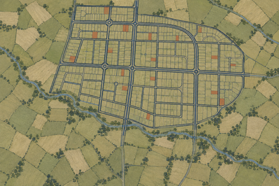
Three files, all published together. Two are drawing sheets at 1:15,000, the Proposed Revised Land Use Plan (drawing 2261/15) and the Proposed Zonal Land Use Plan (drawing 2252/15), both dated 28 December 2015. The third is the text, a 126 page report titled "Detailing of Master Plan New Chandigarh, Volume 1", dated January 2016 and prepared for the Department of Town and Country Planning, Punjab.
Two corrections follow immediately, and both matter because they are repeated everywhere.
The consultant is AECOM, not Jurong. GMADA appointed Jurong Consultants of Singapore in 2007 and that plan was notified in 2008. The document governing New Chandigarh today is AECOM's revision, which retains the Jurong concepts of an Education City and a Medi City but re-does the land use, the densities and the development controls. Nearly every article you will find credits the wrong firm and the wrong plan.
The approval date is 9 December 2015, at the 30th meeting of the Punjab Regional and Town Planning and Development Board. The 28 December is when the drawings were issued. The sheets also record what they replace: drawing 1992/2008 dated 19 November 2008, and that same drawing as revised on 21 June 2013. Both are superseded. Any New Chandigarh zoning map dated before December 2015, and there are several still in circulation, is void.
A city planned for a million people
The report is unambiguous about scale, and the number is far larger than the figures usually quoted.
The LPA covers roughly 15,000 acres, about 6,000 hectares. It has been planned for an ultimate population of approximately 10 lakh by 2058, and the executive summary puts the potential at up to 1.2 million once the residents of Education City and Medi City are counted. The gross residential density applied across the whole area is 170 persons per acre.
Read that against what is there now. The 2011 census data reproduced in the report counts 34,295 people across 33 villages, in 6,424 households. Mullanpur is the largest at around 6,165. Rajgarh had 26 residents. The plan proposes to multiply the population of this area roughly thirtyfold, and it gives itself until 2058 to do it, which is a useful corrective to anyone describing New Chandigarh as nearly finished.
Three density zones, and why the northern belt stays empty
The residential area is not uniform. It is cut into three zones, each with its own density ceiling, and the logic is about approval status rather than geography.
Zone 1 is where township projects were already approved when the plan was drawn, and it takes 150 persons per acre, or 75 dwellings per hectare. Zone 2 is land where projects had not yet been approved, and it takes the highest density in the plan at 200 persons per acre, or 100 dwellings per hectare. The report is explicit that this increase was a deliberate response to demand for affordable housing.
Zone 3 is the low density belt at the foothills of the Shivaliks on the northern edge, capped at 30 persons per acre, or 15 dwellings per hectare. That is a seventh of what is permitted immediately to its south. This is the "country living" designation that has followed Mullanpur since the original plan, and it is the reason the northern edge will never look like the rest of the city. Anyone buying up there on the expectation that density limits will eventually relax is betting against a control written into the approved document.
For calculating population, density applies to the total project area. Under the New Township Policy the minimum area for a township is 100 acres, at least 20 percent of gross area must go to group housing, and the minimum planning size for a residential sector is 100 hectares.
What the land is actually zoned for
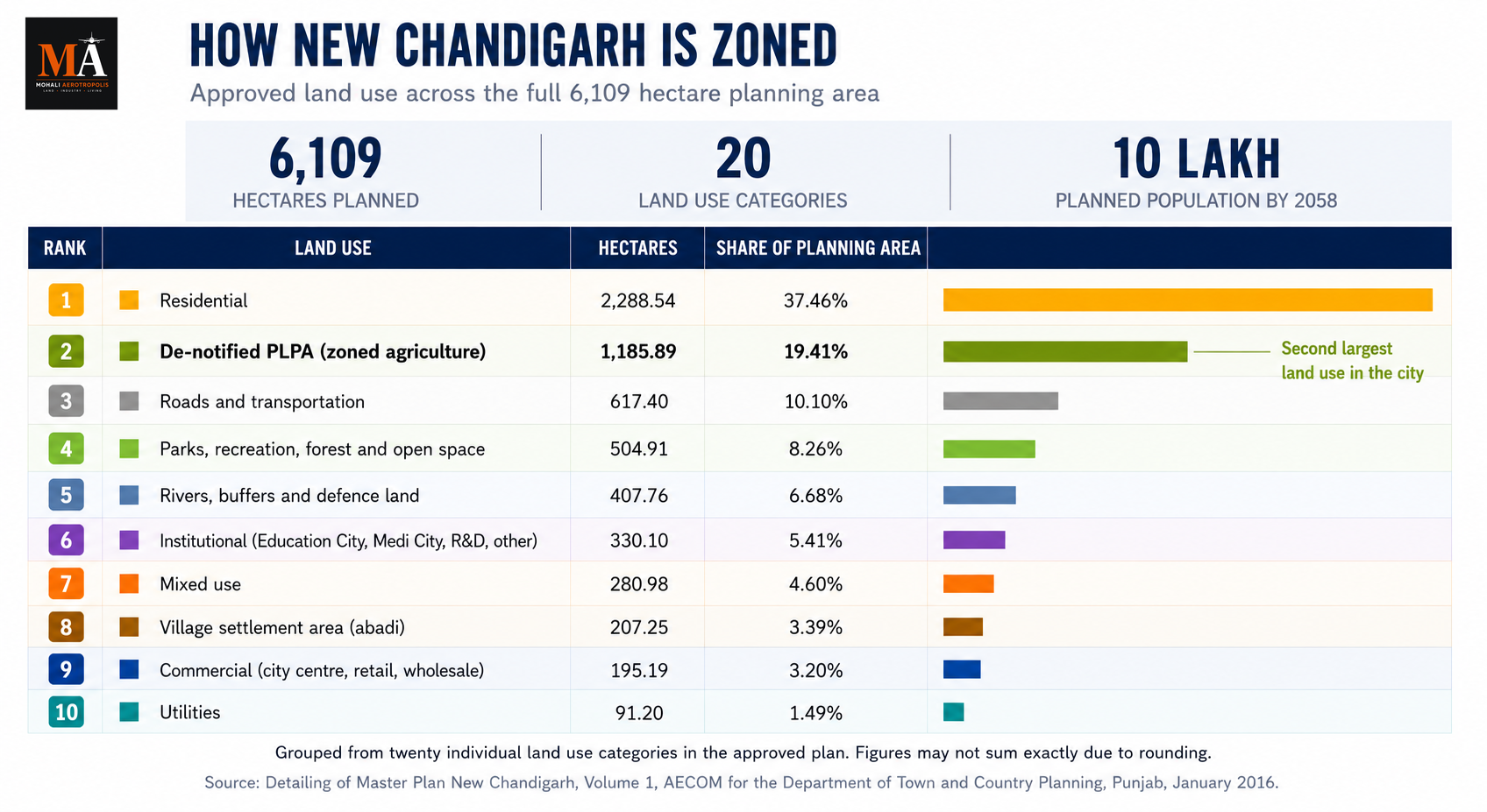
This is the table nobody quotes, covering all 6,109.18 hectares of the LPA.
| Land use | Hectares | Share |
|---|---|---|
| Residential | 2,288.54 | 37.46% |
| De-notified PLPA, Agriculture | 1,185.89 | 19.41% |
| Roads | 576.89 | 9.44% |
| Other (river, riverine buffer, defence buffer) | 327.84 | 5.37% |
| Mixed use | 280.98 | 4.60% |
| Village settlement area (abadi) | 207.25 | 3.39% |
| Forest and open space | 197.58 | 3.23% |
| Recreational | 157.54 | 2.58% |
| Parks | 149.79 | 2.45% |
| Institutional, Medi City | 140.86 | 2.31% |
| Institutional, Education City | 116.38 | 1.91% |
| Utilities | 91.20 | 1.49% |
| Commercial, City Centre | 84.16 | 1.38% |
| Commercial, wholesale and warehouse | 81.22 | 1.33% |
| Defence zone | 79.92 | 1.31% |
| Institutional, research and development | 61.04 | 1.00% |
| Transportation | 40.51 | 0.66% |
| Commercial, retail | 19.94 | 0.33% |
| Institutional, others | 11.82 | 0.19% |
| Commercial, marriage palaces | 9.87 | 0.16% |
The second line is the one to sit with. Roughly 1,150 hectares adjoining the Shivaliks fell under the Punjab Land Preservation Act, was later delisted with restrictions on use, and appears in the approved plan as de-notified PLPA, zoned agriculture. Nearly a fifth of New Chandigarh is agricultural land in the master plan, and it is precisely the land most often described to buyers as freed up and buildable. De-notified is not the same as re-zoned. The plan says agriculture.
There is also a restricted military area of 140.8 hectares with a 100 metre no-construction buffer around its perimeter, and river margins protected through recreational zoning that permits minimal construction. Three constraint layers, none of which appears in any sales pitch.
The sector count does not agree with itself
Here is the oddity, and it is a genuine one rather than a transcription error.
The report states plainly that the LPA "has been planned into 20 distinct sectors". The Zonal Land Use Plan sheet, drawn seven weeks before the report was issued, carries sector numbering that runs to 27.
Both documents were published together as one approved set. The likeliest reconciliation is that the report's twenty refers to residential sectors, its stated context, while the zonal sheet numbers every planned zone including institutional, commercial and utility areas. But the documents do not say that, and until they do, any statement that New Chandigarh has a fixed number of sectors is quoting one file and ignoring the other.
A smaller inconsistency sits alongside it. The report dates the renaming of the Mullanpur LPA to New Chandigarh to 20 February 2014, by the Department of Town and Country Planning. GMADA's own website attributes the renaming to a Punjab Regional and Town Planning and Development Board meeting held on 28 May 2013. Both cannot be the operative date.
Roads that do not exist yet already have names and widths
The plan sheets carry a full road hierarchy, named and dimensioned, which is the closest thing available to a picture of the finished city.
At the top sits Orchard Avenue with a right of way of 270 metres, which is not a road so much as a linear corridor. Shivalik Boulevard is 75 metres and Hyde Park Avenue 58. Sector roads run at 60 and 45 metres: New Chandigarh Boulevard, Central Boulevard, Grand Boulevard, Heritage Boulevard, Northern Avenue, Regent Park Avenue, Royal Palm Avenue, Siswan Avenue, Gulmohar Avenue, Golf Drive, Lake Drive, Medi City Avenue, Campus Drive. Below them, intra-sector roads step down through 30, 24, 18 and 12 metres.
Green buffers are mandated rather than suggested: 15 metres on both sides of MDR-B, and 5 metres on both sides of the 60 metre and 45 metre roads. Group housing requires a minimum 24 metre access road.
The zonal sheet also sites and sizes the civic infrastructure, which tells you how seriously the plan takes the million. An artificial lake of 75 acres. A bus depot of 23 acres and two bus terminals. A combined fire and police station of 15 acres. Cremation grounds of 11 and 12.7 acres. Waterworks of 5 acres, waste water treatment plants at 52, 17, 12, 9.35, 8 and 6.5 acres, two proposed 220 KV grid sites at 8.67 and 6 acres, and a string of 66 KVA substations. A truck terminal, a cultural centre, a cricket stadium with sports complex.
What was already approved, and what was not
The Zonal Land Use Plan carries a legend headed Approved Properties, and it names exactly ten: Omaxe, Altus, DLF Hyde Park, Eco City, IAS/PCS Society, Suntech City, Innovative Housing, Manohar Infra, Curo India and Tata Memorial Hospital.
The report goes further and quantifies four of them.
| Developer | Area (ha) | Planned population | Gross density (ppa) |
|---|---|---|---|
| Omaxe | 238 | 67,068 | 113 |
| Eco City | 162 | 46,770 | 116 |
| DLF | 90 | 21,110 | 94 |
| IAS/PCS | 52 | 10,806 | 83 |
| Total | 542 | 1,45,754 | 108 |
Five hundred and forty two hectares of approved development against a plan of 6,109. Under nine percent of New Chandigarh was spoken for when this document was drawn, and every one of those four sits comfortably below the 150 persons per acre their zone permits. Our projects catalogue and developer profiles track what has been built on that land since.
Why this document explains the notices you are reading now
The plan lists all 33 villages by name. Kartarpur, Kansala, Rajgarh and Boothgarh are on it. Those are the four villages in the Eco City 4 acquisition notified in June 2026, and the four named in the Section 5 hearing notices issued in July. Hoshiarpur, Takipur, Salamatpur and Majra are on it too, and those belong to Eco City 3, whose land pooling window was extended to August 2026.
None of this is improvisation. The acquisitions arriving as news are the state executing a land use map approved in 2015, village by village, in the order the plan implies. Which is also why the timeline is long: the document budgets until 2058 for the population it describes, and a plan with a forty year horizon does not owe anyone a launch date.
For a buyer, the practical use of all this is narrow and specific. Check which zone a parcel sits in before accepting a density claim. Check whether it is de-notified PLPA before accepting that it is buildable. Check the road width the plan assigns to the frontage before accepting that a plot is on a main road. Our buyer's guide covers the title work, and the glossary explains the terms the plan uses without defining.
The document is free, public and dated. Almost every dispute in this market about what New Chandigarh will become is a dispute someone could settle in an afternoon by reading it.
You can follow how the plan is being implemented on our New Chandigarh page, with every fresh notification in the notices archive and continuing coverage in news. Land use plans are amended from time to time, so verify the current version against GMADA's published set before relying on anything here. This is a reading of the plan, not a substitute for it, and it is not legal advice.
---
Sources
- Detailing of Master Plan New Chandigarh, Volume 1, AECOM India Private Limited for the Department of Town and Country Planning, Punjab, January 2016. Land use distribution, density zones, development controls and 2011 village census data
- Proposed Revised Land Use Plan and Proposed Zonal Land Use Plan, New Chandigarh 2008 to 2031, Department of Town and Country Planning, Punjab, drawings dated 28 December 2015, approved at the 30th meeting of the Punjab Regional and Town Planning and Development Board on 9 December 2015
- About Chandigarh, Greater Mohali Area Development Authority, on the origin and renaming of the Mullanpur Local Planning Area
- New Chandigarh: What's in it, The Tribune, 15 July 2013, contemporary reporting on the earlier plan and its revision
न्यू चंडीगढ़ के बारे में लगातार चर्चा होती है, लेकिन इसे लगभग कोई पढ़ता नहीं है। ट्राइसिटी बाज़ार में हर किसी की राय है कि यह किस दिशा में जा रहा है, इसकी कीमत क्या होगी, और अगला पॉकेट कौन सा है। बहुत कम लोगों ने उस दस्तावेज़ को खोला है जो इन तीनों चीज़ों का फैसला करता है, भले ही यह एक दशक से GMADA की वेबसाइट पर मुफ्त डाउनलोड के रूप में उपलब्ध है।
इसे खोलना उचित है। यह योजना इसके बारे में कही जा रही किसी भी बात से कहीं अधिक विशिष्ट है, और कई बिंदुओं पर यह प्रचलित धारणाओं का सपाट खंडन करती है। यह एक संख्या देती है कि यह शहर कितने लोगों को समायोजित करने के लिए बनाया गया है, यह हर आवासीय क्षेत्र का घनत्व तय करती है, यह उन सड़कों के नाम बताती है जो अभी मौजूद नहीं हैं और बताती है कि वे कितनी चौड़ी होंगी, और यह पूरे क्षेत्र के लगभग पाँचवें हिस्से को कृषि के रूप में ज़ोन करती है। साथ ही, एक मामले में यह स्वयं का खंडन भी करती है।
दस्तावेज़ वास्तव में क्या है
तीन फ़ाइलें, सभी एक साथ प्रकाशित। दो ड्रॉइंग शीट हैं 1:15,000 स्केल पर, प्रस्तावित संशोधित भू-उपयोग योजना (ड्रॉइंग 2261/15) और प्रस्तावित ज़ोनल भू-उपयोग योजना (ड्रॉइंग 2252/15), दोनों 28 दिसंबर 2015 की तारीख़ के साथ। तीसरी फ़ाइल टेक्स्ट है, एक 126 पन्नों की रिपोर्ट जिसका शीर्षक है "Detailing of Master Plan New Chandigarh, Volume 1", जनवरी 2016 की तारीख़ के साथ, और यह पंजाब के Department of Town and Country Planning के लिए तैयार की गई थी।
इसके तुरंत बाद दो सुधार आते हैं, और दोनों महत्वपूर्ण हैं क्योंकि इन्हें हर जगह दोहराया जाता है।
सलाहकार AECOM है, Jurong नहीं। GMADA ने 2007 में सिंगापुर के Jurong Consultants को नियुक्त किया था और वह योजना 2008 में अधिसूचित की गई थी। आज न्यू चंडीगढ़ को नियंत्रित करने वाला दस्तावेज़ AECOM का संशोधन है, जो Jurong की Education City और Medi City की अवधारणाओं को बरकरार रखता है, लेकिन भू-उपयोग, घनत्व और विकास नियंत्रणों को नए सिरे से करता है। आपको मिलने वाला लगभग हर लेख गलत फर्म और गलत योजना का श्रेय देता है।
अनुमोदन की तारीख़ 9 दिसंबर 2015 है, पंजाब Regional and Town Planning and Development Board की 30वीं बैठक में। 28 दिसंबर वह तारीख़ है जब ड्रॉइंग जारी की गईं। शीट्स यह भी दर्ज करती हैं कि वे किसे प्रतिस्थापित करती हैं: ड्रॉइंग 1992/2008 दिनांक 19 नवंबर 2008, और वही ड्रॉइंग 21 जून 2013 को संशोधित। दोनों निरस्त हैं। दिसंबर 2015 से पहले की कोई भी न्यू चंडीगढ़ ज़ोनिंग मैप, और कई अभी भी प्रचलन में हैं, अमान्य है।
दस लाख लोगों के लिए नियोजित एक शहर
रिपोर्ट पैमाने के बारे में स्पष्ट है, और यह संख्या आमतौर पर उद्धृत आंकड़ों से कहीं बड़ी है।
LPA लगभग 15,000 एकड़, यानी लगभग 6,000 हेक्टेयर क्षेत्र को कवर करता है। इसे 2058 तक लगभग 10 लाख की अंतिम जनसंख्या के लिए नियोजित किया गया है, और कार्यकारी सारांश Education City और Medi City के निवासियों को जोड़ने के बाद क्षमता 1.2 मिलियन तक बताता है। पूरे क्षेत्र पर लागू सकल आवासीय घनत्व 170 व्यक्ति प्रति एकड़ है।
इसे वहाँ अब जो है उसके सामने रखकर पढ़ें। रिपोर्ट में पुनरुत्पादित 2011 की जनगणना के आँकड़े 6,424 परिवारों में 33 गाँवों में 34,295 लोग गिनते हैं। मुल्लांपुर सबसे बड़ा है, लगभग 6,165। राजगढ़ में 26 निवासी थे। योजना इस क्षेत्र की जनसंख्या को लगभग तीस गुना बढ़ाने का प्रस्ताव करती है, और इसे करने के लिए खुद को 2058 तक का समय देती है, जो न्यू चंडीगढ़ को लगभग पूर्ण बताने वाले किसी भी व्यक्ति के लिए एक उपयोगी सुधार है।
तीन घनत्व क्षेत्र, और उत्तरी पट्टी खाली क्यों रहेगी
आवासीय क्षेत्र एकसमान नहीं है। इसे तीन क्षेत्रों में विभाजित किया गया है, प्रत्येक की अपनी घनत्व सीमा है, और तर्क भौगोलिक स्थिति के बजाय अनुमोदन स्थिति के बारे में है।
ज़ोन 1 वह है जहाँ योजना बनाते समय township परियोजनाएँ पहले ही स्वीकृत थीं, और यह 150 व्यक्ति प्रति एकड़, या 75 आवास प्रति हेक्टेयर लेता है। ज़ोन 2 वह भूमि है जहाँ परियोजनाएँ अभी तक स्वीकृत नहीं हुई थीं, और यह योजना में उच्चतम घनत्व 200 व्यक्ति प्रति एकड़, या 100 आवास प्रति हेक्टेयर लेता है। रिपोर्ट स्पष्ट है कि यह वृद्धि किफायती आवास की माँग के प्रति एक सोच-समझकर किया गया उत्तर थी।
ज़ोन 3 उत्तरी किनारे पर शिवालिक की तलहटी में कम घनत्व वाली पट्टी है, जो 30 व्यक्ति प्रति एकड़, या 15 आवास प्रति हेक्टेयर तक सीमित है। यह उसके दक्षिण में तुरंत अनुमत घनत्व का सातवाँ हिस्सा है। यह "देशी जीवन" पदनाम है जो मूल योजना के बाद से मुल्लांपुर से जुड़ा है, और यही कारण है कि उत्तरी किनारा कभी भी शहर के बाकी हिस्सों जैसा नहीं दिखेगा। कोई भी व्यक्ति जो इस उम्मीद में वहाँ खरीदारी करता है कि घनत्व सीमाएँ अंततः शिथिल होंगी, वह स्वीकृत दस्तावेज़ में लिखे नियंत्रण के खिलाफ दाँव लगा रहा है।
जनसंख्या की गणना के लिए, घनत्व कुल परियोजना क्षेत्र पर लागू होता है। New Township Policy के तहत township के लिए न्यूनतम क्षेत्र 100 एकड़ है, सकल क्षेत्र का कम से कम 20 प्रतिशत group housing के लिए जाना चाहिए, और आवासीय सेक्टर के लिए न्यूनतम योजना आकार 100 हेक्टेयर है।
भूमि वास्तव में किस लिए ज़ोन की गई है
यह वह तालिका है जिसे कोई उद्धृत नहीं करता, जो LPA के सभी 6,109.18 हेक्टेयर को कवर करती है।
| भू-उपयोग | हेक्टेयर | हिस्सा |
|---|---|---|
| आवासीय | 2,288.54 | 37.46% |
| De-notified PLPA, कृषि | 1,185.89 | 19.41% |
| सड़कें | 576.89 | 9.44% |
| अन्य (नदी, नदी किनारे की बफर, रक्षा बफर) | 327.84 | 5.37% |
| मिश्रित उपयोग | 280.98 | 4.60% |
| गाँव बस्ती क्षेत्र (आबादी) | 207.25 | 3.39% |
| वन और खुला स्थान | 197.58 | 3.23% |
| मनोरंजक | 157.54 | 2.58% |
| पार्क | 149.79 | 2.45% |
| संस्थागत, Medi City | 140.86 | 2.31% |
| संस्थागत, Education City | 116.38 | 1.91% |
| उपयोगिताएँ | 91.20 | 1.49% |
| वाणिज्यिक, सिटी सेंटर | 84.16 | 1.38% |
| वाणिज्यिक, थोक और गोदाम | 81.22 | 1.33% |
| रक्षा क्षेत्र | 79.92 | 1.31% |
| संस्थागत, अनुसंधान एवं विकास | 61.04 | 1.00% |
| परिवहन | 40.51 | 0.66% |
| वाणिज्यिक, खुदरा | 19.94 | 0.33% |
| संस्थागत, अन्य | 11.82 | 0.19% |
| वाणिज्यिक, शादी महल | 9.87 | 0.16% |
दूसरी पंक्ति वह है जिस पर ध्यान देना चाहिए। शिवालिक से सटे लगभग 1,150 हेक्टेयर भूमि Punjab Land Preservation Act के अंतर्गत आती थी, बाद में उपयोग पर प्रतिबंधों के साथ इसे सूची से हटा दिया गया, और स्वीकृत योजना में यह de-notified PLPA, कृषि के रूप में ज़ोन दिखाई देती है। न्यू चंडीगढ़ का लगभग पाँचवाँ हिस्सा मास्टर प्लान में कृषि भूमि है, और यह ठीक वही भूमि है जिसे अक्सर खरीदारों को मुक्त और निर्माण योग्य बताया जाता है। De-notified, re-zoned के समान नहीं है। योजना कृषि कहती है।
इसके अलावा 140.8 हेक्टेयर का एक प्रतिबंधित सैन्य क्षेत्र भी है जिसके परिधि के चारों ओर 100 मीटर का नो-कंस्ट्रक्शन बफर है, और नदी के किनारे मनोरंजक ज़ोनिंग के माध्यम से संरक्षित हैं जो न्यूनतम निर्माण की अनुमति देता है। तीन बाधा परतें, जिनमें से कोई भी किसी सेल्स पिच में नहीं दिखती।
सेक्टरों की संख्या स्वयं से सहमत नहीं है
यहाँ विचित्रता है, और यह वास्तविक है, कोई लिप्यंतरण त्रुटि नहीं।
रिपोर्ट स्पष्ट रूप से कहती है कि LPA "20 distinct sectors में नियोजित किया गया है"। Zonal Land Use Plan शीट, जो रिपोर्ट जारी होने से सात सप्ताह पहले तैयार की गई थी, में सेक्टर नंबरिंग 27 तक जाती है।
दोनों दस्तावेज़ एक स्वीकृत सेट के रूप में एक साथ प्रकाशित किए गए थे। सबसे संभावित समाधान यह है कि रिपोर्ट का बीस आवासीय सेक्टरों को संदर्भित करता है, जो इसका कथित संदर्भ है, जबकि ज़ोनल शीट संस्थागत, वाणिज्यिक और उपयोगिता क्षेत्रों सहित हर नियोजित क्षेत्र की संख्या बताती है। लेकिन दस्तावेज़ यह नहीं कहते हैं, और जब तक वे नहीं कहते, न्यू चंडीगढ़ में सेक्टरों की एक निश्चित संख्या होने का कोई भी कथन एक फ़ाइल को उद्धृत कर रहा है और दूसरे को अनदेखा कर रहा है।
इसके साथ एक छोटी सी असंगति भी जुड़ी है। रिपोर्ट मुल्लांपुर LPA के न्यू चंडीगढ़ में नाम बदलने की तारीख़ 20 फरवरी 2014 बताती है, जो Department of Town and Country Planning द्वारा किया गया। GMADA की अपनी वेबसाइट इस नामकरण का श्रेय 28 मई 2013 को हुई Punjab Regional and Town Planning and Development Board की बैठक को देती है। दोनों प्रभावी तारीख़ें नहीं हो सकतीं।
जो सड़कें अभी मौजूद नहीं हैं, उनके नाम और चौड़ाई पहले से तय हैं
योजना की शीट्स में एक पूर्ण सड़क पदानुक्रम है, जिसके नाम और आयाम दिए गए हैं, जो पूर्ण शहर की तस्वीर के सबसे करीब उपलब्ध चीज़ है।
सबसे ऊपर Orchard Avenue है जिसकी right of way 270 मीटर है, जो एक सड़क से अधिक एक रैखिक गलियारा है। Shivalik Boulevard 75 मीटर और Hyde Park Avenue 58 मीटर है। सेक्टर सड़कें 60 और 45 मीटर पर चलती हैं: New Chandigarh Boulevard, Central Boulevard, Grand Boulevard, Heritage Boulevard, Northern Avenue, Regent Park Avenue, Royal Palm Avenue, Siswan Avenue, Gulmohar Avenue, Golf Drive, Lake Drive, Medi City Avenue, Campus Drive। इनके नीचे, इंट्रा-सेक्टर सड़कें 30, 24, 18 और 12 मीटर से नीचे की ओर घटती हैं।
हरित बफर अनिवार्य हैं, सुझाव नहीं: MDR-B के दोनों ओर 15 मीटर, और 60 मीटर और 45 मीटर सड़कों के दोनों ओर 5 मीटर। Group housing के लिए न्यूनतम 24 मीटर एक्सेस रोड आवश्यक है।
ज़ोनल शीट नागरिक बुनियादी ढाँचे का स्थान और आकार भी तय करती है, जो बताता है कि योजना दस लाख की आबादी को कितनी गंभीरता से लेती है। 75 एकड़ की एक कृत्रिम झील। 23 एकड़ का एक बस डिपो और दो बस टर्मिनल। 15 एकड़ का एक संयुक्त अग्निशमन और पुलिस स्टेशन। 11 और 12.7 एकड़ के श्मशान घाट। 5 एकड़ का जल कार्य, 52, 17, 12, 9.35, 8 और 6.5 एकड़ पर अपशिष्ट जल उपचार संयंत्र, 8.67 और 6 एकड़ पर दो प्रस्तावित 220 KV ग्रिड साइटें, और 66 KVA सबस्टेशनों की एक श्रृंखला। एक ट्रक टर्मिनल, एक सांस्कृतिक केंद्र, एक क्रिकेट स्टेडियम के साथ खेल परिसर।
क्या पहले से स्वीकृत था, और क्या नहीं
Zonal Land Use Plan में Approved Properties शीर्षक के साथ एक लीजेंड है, और यह ठीक दस का नाम लेती है: Omaxe, Altus, DLF Hyde Park, Eco City, IAS/PCS Society, Suntech City, Innovative Housing, Manohar Infra, Curo India और Tata Memorial Hospital।
रिपोर्ट आगे जाकर उनमें से चार की मात्रा निर्धारित करती है।
| डेवलपर | क्षेत्र (हेक्टेयर) | नियोजित जनसंख्या | सकल घनत्व (ppa) |
|---|---|---|---|
| Omaxe | 238 | 67,068 | 113 |
| Eco City | 162 | 46,770 | 116 |
| DLF | 90 | 21,110 | 94 |
| IAS/PCS | 52 | 10,806 | 83 |
| कुल | 542 | 1,45,754 | 108 |
6,109 की योजना के मुकाबले 542 हेक्टेयर स्वीकृत विकास। यह दस्तावेज़ बनाते समय न्यू चंडीगढ़ का नौ प्रतिशत से भी कम हिस्सा आरक्षित था, और उन चारों में से प्रत्येक अपने क्षेत्र द्वारा अनुमत 150 व्यक्ति प्रति एकड़ से आराम से नीचे है। हमारा projects catalogue और developer profiles उस भूमि पर तब से क्या बनाया गया है, इसका ट्रैक रखते हैं।
यह दस्तावेज़ उन सूचनाओं की व्याख्या क्यों करता है जिन्हें आप अभी पढ़ रहे हैं
यह योजना सभी 33 गाँवों को नाम से सूचीबद्ध करती है। Kartarpur, Kansala, Rajgarh और Boothgarh इस पर हैं। वे चार गाँव हैं जो जून 2026 में अधिसूचित Eco City 4 अधिग्रहण में हैं, और वही चार जिनका नाम जुलाई में जारी Section 5 सुनवाई सूचनाओं में है। Hoshiarpur, Takipur, Salamatpur और Majra भी इस पर हैं, और वे Eco City 3 से संबंधित हैं, जिसकी land pooling विंडो अगस्त 2026 तक बढ़ा दी गई थी।
इनमें से कुछ भी तात्कालिक निर्णय नहीं है। समाचार के रूप में आ रहे अधिग्रहण, राज्य द्वारा 2015 में स्वीकृत भू-उपयोग मानचित्र को गाँव-दर-गाँव, उस क्रम में निष्पादित करना है जो योजना का तात्पर्य है। यही कारण है कि समय-सीमा लंबी है: दस्तावेज़ जिस जनसंख्या का वर्णन करता है, उसके लिए 2058 तक का बजट देता है, और चालीस वर्ष के क्षितिज वाली योजना किसी को लॉन्च तारीख़ देने की हक़दार नहीं है।
खरीदार के लिए, इन सबका व्यावहारिक उपयोग संकीर्ण और विशिष्ट है। घनत्व के दावे को स्वीकार करने से पहले जाँचें कि कोई प्लॉट किस ज़ोन में है। निर्माण योग्य होने को स्वीकार करने से पहले जाँचें कि क्या वह de-notified PLPA है। किसी प्लॉट को मुख्य सड़क पर मानने से पहले योजना द्वारा सामने की सड़क को सौंपी गई चौड़ाई जाँचें। हमारा buyer's guide title के काम को कवर करता है, और glossary उन शब्दों की व्याख्या करता है जिन्हें योजना बिना परिभाषित किए उपयोग करती है।
दस्तावेज़ मुफ्त, सार्वजनिक और तारीख़दार है। इस बाज़ार में न्यू चंडीगढ़ क्या बनेगा, इस बारे में लगभग हर विवाद ऐसा विवाद है जिसे कोई व्यक्ति उसे
ਨਿਊ ਚੰਡੀਗੜ੍ਹ ਬਾਰੇ ਲਗਾਤਾਰ ਚਰਚਾ ਹੁੰਦੀ ਹੈ ਪਰ ਇਸਨੂੰ ਲਗਭਗ ਕਦੇ ਪੜ੍ਹਿਆ ਨਹੀਂ ਜਾਂਦਾ। ਤ੍ਰਿਸਿਟੀ ਮਾਰਕੀਟ ਵਿੱਚ ਹਰ ਕਿਸੇ ਦੀ ਆਪਣੀ ਰਾਏ ਹੈ ਕਿ ਇਹ ਕਿੱਥੇ ਜਾ ਰਿਹਾ ਹੈ, ਇਸਦੀ ਕੀਮਤ ਕੀ ਹੋਵੇਗੀ, ਅਤੇ ਅਗਲਾ ਕਿਹੜਾ ਪਾਕੇਟ ਹੈ। ਬਹੁਤ ਘੱਟ ਲੋਕਾਂ ਨੇ ਉਹ ਦਸਤਾਵੇਜ਼ ਖੋਲ੍ਹਿਆ ਹੈ ਜੋ ਇਹਨਾਂ ਤਿੰਨਾਂ ਦਾ ਫੈਸਲਾ ਕਰਦਾ ਹੈ, ਭਾਵੇਂ ਇਹ ਇੱਕ ਦਹਾਕੇ ਤੋਂ GMADA ਦੀ ਵੈੱਬਸਾਈਟ 'ਤੇ ਮੁਫਤ ਡਾਊਨਲੋਡ ਲਈ ਪਿਆ ਹੋਇਆ ਹੈ।
ਇਸਨੂੰ ਖੋਲ੍ਹਣਾ ਯੋਗ ਹੈ। ਇਹ ਯੋਜਨਾ ਇਸ ਬਾਰੇ ਕਹੀ ਜਾ ਰਹੀ ਕਿਸੇ ਵੀ ਗੱਲ ਨਾਲੋਂ ਕਿਤੇ ਵੱਧ ਖਾਸ ਹੈ, ਅਤੇ ਕਈ ਮੁੱਦਿਆਂ 'ਤੇ ਇਹ ਸਪਸ਼ਟ ਤੌਰ 'ਤੇ ਉਹਨਾਂ ਗੱਲਾਂ ਦਾ ਖੰਡਨ ਕਰਦੀ ਹੈ ਜੋ ਚਰਚਾ ਵਿੱਚ ਹਨ। ਇਹ ਦੱਸਦੀ ਹੈ ਕਿ ਇਹ ਸ਼ਹਿਰ ਕਿੰਨੇ ਲੋਕਾਂ ਲਈ ਬਣਾਇਆ ਗਿਆ ਹੈ, ਇਹ ਹਰ ਰਿਹਾਇਸ਼ੀ ਜ਼ੋਨ ਦੀ ਘਣਤਾ ਨਿਰਧਾਰਤ ਕਰਦੀ ਹੈ, ਇਹ ਉਹਨਾਂ ਸੜਕਾਂ ਦੇ ਨਾਮ ਦੱਸਦੀ ਹੈ ਜੋ ਅਜੇ ਮੌਜੂਦ ਨਹੀਂ ਹਨ ਅਤੇ ਦੱਸਦੀ ਹੈ ਕਿ ਉਹ ਕਿੰਨੀਆਂ ਚੌੜੀਆਂ ਹੋਣਗੀਆਂ, ਅਤੇ ਇਹ ਲਗਭਗ ਪੰਜਵਾਂ ਹਿੱਸਾ ਖੇਤਰ ਖੇਤੀਬਾੜੀ ਲਈ ਨਿਰਧਾਰਤ ਕਰਦੀ ਹੈ। ਇਹ, ਇੱਕ ਮਾਮਲੇ ਵਿੱਚ, ਆਪਣਾ ਖੰਡਨ ਵੀ ਕਰਦੀ ਹੈ।
ਦਸਤਾਵੇਜ਼ ਅਸਲ ਵਿੱਚ ਕੀ ਹੈ
ਤਿੰਨ ਫਾਈਲਾਂ, ਸਾਰੀਆਂ ਇਕੱਠੀਆਂ ਪ੍ਰਕਾਸ਼ਿਤ। ਦੋ ਡਰਾਇੰਗ ਸ਼ੀਟਾਂ ਹਨ 1:15,000 ਦੇ ਪੈਮਾਨੇ 'ਤੇ, ਪ੍ਰਸਤਾਵਿਤ ਸੰਸ਼ੋਧਿਤ ਭੂਮੀ ਉਪਯੋਗ ਯੋਜਨਾ (ਡਰਾਇੰਗ 2261/15) ਅਤੇ ਪ੍ਰਸਤਾਵਿਤ ਜ਼ੋਨਲ ਭੂਮੀ ਉਪਯੋਗ ਯੋਜਨਾ (ਡਰਾਇੰਗ 2252/15), ਦੋਵੇਂ 28 ਦਸੰਬਰ 2015 ਨੂੰ ਦਿਨਾਂਕਿਤ। ਤੀਜੀ ਟੈਕਸਟ ਹੈ, ਇੱਕ 126 ਪੰਨਿਆਂ ਦੀ ਰਿਪੋਰਟ ਜਿਸਦਾ ਸਿਰਲੇਖ ਹੈ "Detailing of Master Plan New Chandigarh, Volume 1", ਜਨਵਰੀ 2016 ਨੂੰ ਦਿਨਾਂਕਿਤ ਅਤੇ ਪੰਜਾਬ ਦੇ ਵਿਭਾਗ ਆਫ਼ ਟਾਊਨ ਐਂਡ ਕੰਟਰੀ ਪਲੈਨਿੰਗ ਲਈ ਤਿਆਰ ਕੀਤੀ ਗਈ।
ਦੋ ਸੁਧਾਰ ਤੁਰੰਤ ਆਉਂਦੇ ਹਨ, ਅਤੇ ਦੋਵੇਂ ਮਹੱਤਵਪੂਰਨ ਹਨ ਕਿਉਂਕਿ ਇਹ ਹਰ ਥਾਂ ਦੁਹਰਾਏ ਜਾਂਦੇ ਹਨ।
ਸਲਾਹਕਾਰ AECOM ਹੈ, Jurong ਨਹੀਂ। GMADA ਨੇ 2007 ਵਿੱਚ ਸਿੰਗਾਪੁਰ ਦੇ Jurong ਕੰਸਲਟੈਂਟਸ ਨੂੰ ਨਿਯੁਕਤ ਕੀਤਾ ਸੀ ਅਤੇ ਉਹ ਯੋਜਨਾ 2008 ਵਿੱਚ ਅਧਿਸੂਚਿਤ ਕੀਤੀ ਗਈ ਸੀ। ਅੱਜ ਨਿਊ ਚੰਡੀਗੜ੍ਹ ਨੂੰ ਨਿਯੰਤਰਿਤ ਕਰਨ ਵਾਲਾ ਦਸਤਾਵੇਜ਼ AECOM ਦਾ ਸੋਧ ਹੈ, ਜੋ Jurong ਦੀ ਧਾਰਨਾ ਨੂੰ ਬਰਕਰਾਰ ਰੱਖਦਾ ਹੈ ਐਜੂਕੇਸ਼ਨ ਸਿਟੀ ਅਤੇ ਮੈਡੀ ਸਿਟੀ ਦੀ ਪਰ ਭੂਮੀ ਉਪਯੋਗ, ਘਣਤਾ ਅਤੇ ਵਿਕਾਸ ਨਿਯੰਤਰਣਾਂ ਨੂੰ ਦੁਬਾਰਾ ਕਰਦਾ ਹੈ। ਲਗਭਗ ਹਰ ਲੇਖ ਜੋ ਤੁਸੀਂ ਲੱਭੋਗੇ ਗਲਤ ਫਰਮ ਅਤੇ ਗਲਤ ਯੋਜਨਾ ਦਾ ਸਿਹਰਾ ਦਿੰਦਾ ਹੈ।
ਮਨਜ਼ੂਰੀ ਦੀ ਮਿਤੀ 9 ਦਸੰਬਰ 2015 ਹੈ, ਪੰਜਾਬ ਰੀਜਨਲ ਐਂਡ ਟਾਊਨ ਪਲੈਨਿੰਗ ਐਂਡ ਡਿਵੈਲਪਮੈਂਟ ਬੋਰਡ ਦੀ 30ਵੀਂ ਮੀਟਿੰਗ ਵਿੱਚ। 28 ਦਸੰਬਰ ਉਹ ਮਿਤੀ ਹੈ ਜਦੋਂ ਡਰਾਇੰਗ ਜਾਰੀ ਕੀਤੀਆਂ ਗਈਆਂ ਸਨ। ਸ਼ੀਟਾਂ ਇਹ ਵੀ ਦਰਜ ਕਰਦੀਆਂ ਹਨ ਕਿ ਉਹ ਕੀ ਬਦਲਦੀਆਂ ਹਨ: ਡਰਾਇੰਗ 1992/2008 ਜੋ 19 ਨਵੰਬਰ 2008 ਨੂੰ ਦਿਨਾਂਕਿਤ ਸੀ, ਅਤੇ ਉਹੀ ਡਰਾਇੰਗ ਜਿਵੇਂ 21 ਜੂਨ 2013 ਨੂੰ ਸੋਧੀ ਗਈ ਸੀ। ਦੋਵੇਂ ਰੱਦ ਕਰ ਦਿੱਤੀਆਂ ਗਈਆਂ ਹਨ। ਦਸੰਬਰ 2015 ਤੋਂ ਪਹਿਲਾਂ ਦੀ ਕੋਈ ਵੀ ਨਿਊ ਚੰਡੀਗੜ੍ਹ ਜ਼ੋਨਿੰਗ ਨਕਸ਼ਾ, ਅਤੇ ਅਜੇ ਵੀ ਕਈ ਪ੍ਰਚਲਨ ਵਿੱਚ ਹਨ, ਰੱਦ ਹੈ।
ਇੱਕ ਮਿਲੀਅਨ ਲੋਕਾਂ ਲਈ ਯੋਜਨਾਬੱਧ ਸ਼ਹਿਰ
ਰਿਪੋਰਟ ਪੈਮਾਨੇ ਬਾਰੇ ਸਪਸ਼ਟ ਹੈ, ਅਤੇ ਇਹ ਗਿਣਤੀ ਆਮ ਤੌਰ 'ਤੇ ਦੱਸੇ ਗਏ ਅੰਕੜਿਆਂ ਨਾਲੋਂ ਕਿਤੇ ਵੱਡੀ ਹੈ।
LPA ਲਗਭਗ 15,000 ਏਕੜ, ਲਗਭਗ 6,000 ਹੈਕਟੇਅਰ ਕਵਰ ਕਰਦਾ ਹੈ। ਇਸਦੀ ਯੋਜਨਾ 2058 ਤੱਕ ਲਗਭਗ 10 ਲੱਖ ਦੀ ਅੰਤਿਮ ਆਬਾਦੀ ਲਈ ਬਣਾਈ ਗਈ ਹੈ, ਅਤੇ ਕਾਰਜਕਾਰੀ ਸਾਰਾਂਸ਼ ਵਿੱਚ ਇੱਕ ਵਾਰ ਐਜੂਕੇਸ਼ਨ ਸਿਟੀ ਅਤੇ ਮੈਡੀ ਸਿਟੀ ਦੇ ਨਿਵਾਸੀਆਂ ਦੀ ਗਿਣਤੀ ਕੀਤੀ ਜਾਵੇ ਤਾਂ ਇਹ ਸਮਰੱਥਾ 1.2 ਮਿਲੀਅਨ ਤੱਕ ਹੋ ਸਕਦੀ ਹੈ। ਪੂਰੇ ਖੇਤਰ ਵਿੱਚ ਲਾਗੂ ਕੀਤੀ ਗਈ ਸਮੂਹਿਕ ਰਿਹਾਇਸ਼ੀ ਘਣਤਾ 170 ਵਿਅਕਤੀ ਪ੍ਰਤੀ ਏਕੜ ਹੈ।
ਇਸਦੀ ਤੁਲਨਾ ਉਸ ਨਾਲ ਕਰੋ ਜੋ ਹੁਣ ਉੱਥੇ ਹੈ। ਰਿਪੋਰਟ ਵਿੱਚ ਦੁਬਾਰਾ ਪੇਸ਼ ਕੀਤਾ ਗਿਆ 2011 ਦਾ ਜਨਗਣਨਾ ਡੇਟਾ 33 ਪਿੰਡਾਂ ਵਿੱਚ 34,295 ਲੋਕਾਂ ਨੂੰ, 6,424 ਪਰਿਵਾਰਾਂ ਵਿੱਚ ਗਿਣਦਾ ਹੈ। ਮੁੱਲਾਂਪੁਰ ਸਭ ਤੋਂ ਵੱਡਾ ਹੈ ਲਗਭਗ 6,165। ਰਾਜਗੜ੍ਹ ਵਿੱਚ 26 ਨਿਵਾਸੀ ਸਨ। ਯੋਜਨਾ ਇਸ ਖੇਤਰ ਦੀ ਆਬਾਦੀ ਨੂੰ ਲਗਭਗ ਤੀਹ ਗੁਣਾ ਵਧਾਉਣ ਦਾ ਪ੍ਰਸਤਾਵ ਕਰਦੀ ਹੈ, ਅਤੇ ਆਪਣੇ ਆਪ ਨੂੰ ਇਹ ਕਰਨ ਲਈ 2058 ਤੱਕ ਦਾ ਸਮਾਂ ਦਿੰਦੀ ਹੈ, ਜੋ ਕਿ ਕਿਸੇ ਵੀ ਵਿਅਕਤੀ ਲਈ ਇੱਕ ਲਾਭਦਾਇਕ ਸੁਧਾਰ ਹੈ ਜੋ ਨਿਊ ਚੰਡੀਗੜ੍ਹ ਨੂੰ ਲਗਭਗ ਮੁਕੰਮਲ ਦੱਸ ਰਿਹਾ ਹੈ।
ਤਿੰਨ ਘਣਤਾ ਜ਼ੋਨ, ਅਤੇ ਉੱਤਰੀ ਪੱਟੀ ਖਾਲੀ ਕਿਉਂ ਰਹਿੰਦੀ ਹੈ
ਰਿਹਾਇਸ਼ੀ ਖੇਤਰ ਇੱਕਸਾਰ ਨਹੀਂ ਹੈ। ਇਹ ਤਿੰਨ ਜ਼ੋਨਾਂ ਵਿੱਚ ਵੰਡਿਆ ਗਿਆ ਹੈ, ਹਰ ਇੱਕ ਦੀ ਆਪਣੀ ਘਣਤਾ ਸੀਮਾ ਹੈ, ਅਤੇ ਤਰਕ ਭੂਗੋਲ ਦੀ ਬਜਾਏ ਮਨਜ਼ੂਰੀ ਸਥਿਤੀ ਬਾਰੇ ਹੈ।
ਜ਼ੋਨ 1 ਉਹ ਹੈ ਜਿੱਥੇ ਯੋਜਨਾ ਬਣਾਉਣ ਵੇਲੇ ਟਾਊਨਸ਼ਿਪ ਪ੍ਰੋਜੈਕਟਾਂ ਨੂੰ ਪਹਿਲਾਂ ਹੀ ਮਨਜ਼ੂਰੀ ਦਿੱਤੀ ਗਈ ਸੀ, ਅਤੇ ਇਹ 150 ਵਿਅਕਤੀ ਪ੍ਰਤੀ ਏਕੜ, ਜਾਂ 75 ਰਿਹਾਇਸ਼ਾਂ ਪ੍ਰਤੀ ਹੈਕਟੇਅਰ ਲੈਂਦਾ ਹੈ। ਜ਼ੋਨ 2 ਉਹ ਜ਼ਮੀਨ ਹੈ ਜਿੱਥੇ ਪ੍ਰੋਜੈਕਟਾਂ ਨੂੰ ਅਜੇ ਮਨਜ਼ੂਰੀ ਨਹੀਂ ਦਿੱਤੀ ਗਈ ਸੀ, ਅਤੇ ਇਹ ਯੋਜਨਾ ਵਿੱਚ ਸਭ ਤੋਂ ਵੱਧ ਘਣਤਾ ਲੈਂਦਾ ਹੈ 200 ਵਿਅਕਤੀ ਪ੍ਰਤੀ ਏਕੜ, ਜਾਂ 100 ਰਿਹਾਇਸ਼ਾਂ ਪ੍ਰਤੀ ਹੈਕਟੇਅਰ। ਰਿਪੋਰਟ ਸਪਸ਼ਟ ਹੈ ਕਿ ਇਹ ਵਾਧਾ ਕਿਫਾਇਤੀ ਰਿਹਾਇਸ਼ ਦੀ ਮੰਗ ਦਾ ਜਾਣਬੁੱਝ ਕੇ ਜਵਾਬ ਸੀ।
ਜ਼ੋਨ 3 ਉੱਤਰੀ ਕਿਨਾਰੇ 'ਤੇ ਸ਼ਿਵਾਲਿਕ ਦੀਆਂ ਤਲਹਟੀਆਂ ਵਿੱਚ ਘੱਟ ਘਣਤਾ ਵਾਲੀ ਪੱਟੀ ਹੈ, ਜੋ ਕਿ 30 ਵਿਅਕਤੀ ਪ੍ਰਤੀ ਏਕੜ, ਜਾਂ 15 ਰਿਹਾਇਸ਼ਾਂ ਪ੍ਰਤੀ ਹੈਕਟੇਅਰ ਤੱਕ ਸੀਮਤ ਹੈ। ਇਹ ਉਸਦੇ ਦੱਖਣ ਵਿੱਚ ਤੁਰੰਤ ਮਨਜ਼ੂਰ ਕੀਤੇ ਗਏ ਦਾ ਸੱਤਵਾਂ ਹਿੱਸਾ ਹੈ। ਇਹ "ਕੰਟਰੀ ਲਿਵਿੰਗ" ਪਦਨਾਮ ਹੈ ਜੋ ਮੂਲ ਯੋਜਨਾ ਤੋਂ ਮੁੱਲਾਂਪੁਰ ਦਾ ਪਿੱਛਾ ਕਰ ਰਿਹਾ ਹੈ, ਅਤੇ ਇਹੀ ਕਾਰਨ ਹੈ ਕਿ ਉੱਤਰੀ ਕਿਨਾਰਾ ਕਦੇ ਵੀ ਬਾਕੀ ਸ਼ਹਿਰ ਵਰਗਾ ਨਹੀਂ ਦਿਖੇਗਾ। ਕੋਈ ਵੀ ਵਿਅਕਤੀ ਜੋ ਉੱਥੇ ਇਸ ਉਮੀਦ 'ਤੇ ਖਰੀਦਦਾ ਹੈ ਕਿ ਘਣਤਾ ਸੀਮਾਵਾਂ ਆਖਰਕਾਰ ਢਿੱਲੀਆਂ ਹੋ ਜਾਣਗੀਆਂ, ਉਹ ਮਨਜ਼ੂਰ ਦਸਤਾਵੇਜ਼ ਵਿੱਚ ਲਿਖੇ ਨਿਯੰਤਰਣ ਦੇ ਵਿਰੁੱਧ ਸੱਟਾ ਲਗਾ ਰਿਹਾ ਹੈ।
ਆਬਾਦੀ ਦੀ ਗਣਨਾ ਕਰਨ ਲਈ, ਘਣਤਾ ਕੁੱਲ ਪ੍ਰੋਜੈਕਟ ਖੇਤਰ 'ਤੇ ਲਾਗੂ ਹੁੰਦੀ ਹੈ। ਨਿਊ ਟਾਊਨਸ਼ਿਪ ਪਾਲਿਸੀ ਦੇ ਤਹਿਤ ਟਾਊਨਸ਼ਿਪ ਲਈ ਘੱਟੋ-ਘੱਟ ਖੇਤਰ 100 ਏਕੜ ਹੈ, ਘੱਟੋ-ਘੱਟ 20 ਪ੍ਰਤੀਸ਼ਤ ਸਮੂਹਿਕ ਰਿਹਾਇਸ਼ ਲਈ ਜਾਣਾ ਚਾਹੀਦਾ ਹੈ, ਅਤੇ ਰਿਹਾਇਸ਼ੀ ਸੈਕਟਰ ਲਈ ਘੱਟੋ-ਘੱਟ ਯੋਜਨਾ ਆਕਾਰ 100 ਹੈਕਟੇਅਰ ਹੈ।
ਜ਼ਮੀਨ ਅਸਲ ਵਿੱਚ ਕਿਸ ਲਈ ਜ਼ੋਨ ਕੀਤੀ ਗਈ ਹੈ
ਇਹ ਉਹ ਸਾਰਣੀ ਹੈ ਜੋ ਕੋਈ ਵੀ ਹਵਾਲਾ ਨਹੀਂ ਦਿੰਦਾ, ਜੋ LPA ਦੇ ਸਾਰੇ 6,109.18 ਹੈਕਟੇਅਰ ਨੂੰ ਕਵਰ ਕਰਦੀ ਹੈ।
| ਭੂਮੀ ਉਪਯੋਗ | ਹੈਕਟੇਅਰ | ਹਿੱਸਾ |
|---|---|---|
| ਰਿਹਾਇਸ਼ੀ | 2,288.54 | 37.46% |
| ਡੀ-ਨੋਟੀਫਾਈਡ PLPA, ਖੇਤੀਬਾੜੀ | 1,185.89 | 19.41% |
| ਸੜਕਾਂ | 576.89 | 9.44% |
| ਹੋਰ (ਦਰਿਆ, ਦਰਿਆ ਕਿਨਾਰੇ ਬਫਰ, ਰੱਖਿਆ ਬਫਰ) | 327.84 | 5.37% |
| ਮਿਕਸਡ ਉਪਯੋਗ | 280.98 | 4.60% |
| ਪਿੰਡ ਵਸੋਂ ਖੇਤਰ (ਆਬਾਦੀ) | 207.25 | 3.39% |
| ਜੰਗਲ ਅਤੇ ਖੁੱਲੀ ਥਾਂ | 197.58 | 3.23% |
| ਮਨੋਰੰਜਨ | 157.54 | 2.58% |
| ਪਾਰਕ | 149.79 | 2.45% |
| ਸੰਸਥਾਗਤ, ਮੈਡੀ ਸਿਟੀ | 140.86 | 2.31% |
| ਸੰਸਥਾਗਤ, ਐਜੂਕੇਸ਼ਨ ਸਿਟੀ | 116.38 | 1.91% |
| ਉਪਯੋਗਤਾਵਾਂ | 91.20 | 1.49% |
| ਵਪਾਰਕ, ਸਿਟੀ ਸੈਂਟਰ | 84.16 | 1.38% |
| ਵਪਾਰਕ, ਥੋਕ ਅਤੇ ਗੋਦਾਮ | 81.22 | 1.33% |
| ਰੱਖਿਆ ਜ਼ੋਨ | 79.92 | 1.31% |
| ਸੰਸਥਾਗਤ, ਖੋਜ ਅਤੇ ਵਿਕਾਸ | 61.04 | 1.00% |
| ਆਵਾਜਾਈ | 40.51 | 0.66% |
| ਵਪਾਰਕ, ਪ੍ਰਚੂਨ | 19.94 | 0.33% |
| ਸੰਸਥਾਗਤ, ਹੋਰ | 11.82 | 0.19% |
| ਵਪਾਰਕ, ਵਿਆਹ ਮਹਿਲ | 9.87 | 0.16% |
ਦੂਜੀ ਲਾਈਨ ਉਹ ਹੈ ਜਿਸ 'ਤੇ ਧਿਆਨ ਦੇਣਾ ਚਾਹੀਦਾ ਹੈ। ਸ਼ਿਵਾਲਿਕ ਨਾਲ ਲਗਭਗ 1,150 ਹੈਕਟੇਅਰ ਜ਼ਮੀਨ ਪੰਜਾਬ ਲੈਂਡ ਪ੍ਰਿਜ਼ਰਵੇਸ਼ਨ ਐਕਟ ਦੇ ਅਧੀਨ ਆਈ ਸੀ, ਬਾਅਦ ਵਿੱਚ ਵਰਤੋਂ 'ਤੇ ਪਾਬੰਦੀਆਂ ਦੇ ਨਾਲ ਸੂਚੀ ਤੋਂ ਬਾਹਰ ਕਰ ਦਿੱਤੀ ਗਈ, ਅਤੇ ਮਨਜ਼ੂਰ ਯੋਜਨਾ ਵਿੱਚ ਡੀ-ਨੋਟੀਫਾਈਡ PLPA, ਜ਼ੋਨਡ ਖੇਤੀਬਾੜੀ ਵਜੋਂ ਦਿਖਾਈ ਦਿੰਦੀ ਹੈ। ਨਿਊ ਚੰਡੀਗੜ੍ਹ ਦਾ ਲਗਭਗ ਪੰਜਵਾਂ ਹਿੱਸਾ ਮਾਸਟਰ ਪਲਾਨ ਵਿੱਚ ਖੇਤੀਬਾੜੀ ਜ਼ਮੀਨ ਹੈ, ਅਤੇ ਇਹ ਬਿਲਕੁਲ ਉਹੀ ਜ਼ਮੀਨ ਹੈ ਜਿਸਨੂੰ ਅਕਸਰ ਖਰੀਦਦਾਰਾਂ ਨੂੰ ਆਜ਼ਾਦ ਅਤੇ ਉਸਾਰੀਯੋਗ ਦੱਸਿਆ ਜਾਂਦਾ ਹੈ। ਡੀ-ਨੋਟੀਫਾਈਡ ਦਾ ਮਤਲਬ ਰੀ-ਜ਼ੋਨਡ ਨਹੀਂ ਹੈ। ਯੋਜਨਾ ਖੇਤੀਬਾੜੀ ਕਹਿੰਦੀ ਹੈ।
ਇੱਥੇ 140.8 ਹੈਕਟੇਅਰ ਦਾ ਇੱਕ ਪ੍ਰਤਿਬੰਧਿਤ ਫੌਜੀ ਖੇਤਰ ਵੀ ਹੈ ਜਿਸਦੇ ਘੇਰੇ ਦੇ ਦੁਆਲੇ 100 ਮੀਟਰ ਦਾ ਨੋ-ਨਿਰਮਾਣ ਬਫਰ ਹੈ, ਅਤੇ ਦਰਿਆ ਦੇ ਕਿਨਾਰੇ ਮਨੋਰੰਜਨ ਜ਼ੋਨਿੰਗ ਦੁਆਰਾ ਸੁਰੱਖਿਅਤ ਹਨ ਜੋ ਘੱਟੋ-ਘੱਟ ਨਿਰਮਾਣ ਦੀ ਆਗਿਆ ਦਿੰਦੇ ਹਨ। ਤਿੰਨ ਪਾਬੰਦੀ ਪਰਤਾਂ, ਜਿਨ੍ਹਾਂ ਵਿੱਚੋਂ ਕੋਈ ਵੀ ਕਿਸੇ ਵੀ ਵਿਕਰੀ ਪਿੱਚ ਵਿੱਚ ਨਹੀਂ ਦਿਖਾਈ ਦਿੰਦੀ।
ਸੈਕਟਰ ਗਿਣਤੀ ਆਪਣੇ ਆਪ ਨਾਲ ਸਹਿਮਤ ਨਹੀਂ ਹੈ
ਇਹ ਵਿਸੰਗਤੀ ਹੈ, ਅਤੇ ਇਹ ਇੱਕ ਸੱਚੀ ਵਿਸੰਗਤੀ ਹੈ ਨਾ ਕਿ ਟਾਈਪਿੰਗ ਦੀ ਗਲਤੀ।
ਰਿਪੋਰਟ ਸਪਸ਼ਟ ਤੌਰ 'ਤੇ ਦੱਸਦੀ ਹੈ ਕਿ LPA "20 ਵੱਖਰੇ ਸੈਕਟਰਾਂ ਵਿੱਚ ਯੋਜਨਾਬੱਧ ਕੀਤਾ ਗਿਆ ਹੈ"। ਜ਼ੋਨਲ ਭੂਮੀ ਉਪਯੋਗ ਯੋਜਨਾ ਸ਼ੀਟ, ਜੋ ਰਿਪੋਰਟ ਜਾਰੀ ਹੋਣ ਤੋਂ ਸੱਤ ਹਫ਼ਤੇ ਪਹਿਲਾਂ ਤਿਆਰ ਕੀਤੀ ਗਈ ਸੀ, ਵਿੱਚ ਸੈਕਟਰ ਨੰਬਰਿੰਗ ਹੈ ਜੋ 27 ਤੱਕ ਜਾਂਦੀ ਹੈ।
ਦੋਵੇਂ ਦਸਤਾਵੇਜ਼ ਇੱਕ ਮਨਜ਼ੂਰ ਸੈੱਟ ਵਜੋਂ ਇਕੱਠੇ ਪ੍ਰਕਾਸ਼ਿਤ ਕੀਤੇ ਗਏ ਸਨ। ਸਭ ਤੋਂ ਸੰਭਾਵਿਤ ਮੇਲ-ਜੋਲ ਇਹ ਹੈ ਕਿ ਰਿਪੋਰਟ ਦੇ ਵੀਹ ਰਿਹਾਇਸ਼ੀ ਸੈਕਟਰਾਂ ਨੂੰ ਦਰਸਾਉਂਦੇ ਹਨ, ਇਸਦਾ ਦੱਸਿਆ ਗਿਆ ਸੰਦਰਭ, ਜਦੋਂ ਕਿ ਜ਼ੋਨਲ ਸ਼ੀਟ ਸੰਸਥਾਗਤ, ਵਪਾਰਕ ਅਤੇ ਉਪਯੋਗਤਾ ਖੇਤਰਾਂ ਸਮੇਤ ਹਰ ਯੋਜਨਾਬੱਧ ਜ਼ੋਨ ਨੂੰ ਨੰਬਰ ਦਿੰਦੀ ਹੈ। ਪਰ ਦਸਤਾਵੇਜ਼ ਇਹ ਨਹੀਂ ਕਹਿੰਦੇ, ਅਤੇ ਜਦੋਂ ਤੱਕ ਉਹ ਨਹੀਂ ਕਹਿੰਦੇ, ਕੋਈ ਵੀ ਬਿਆਨ ਕਿ ਨਿਊ ਚੰਡੀਗੜ੍ਹ ਵਿੱਚ ਸੈਕਟਰਾਂ ਦੀ ਇੱਕ ਨਿਸ਼ਚਿਤ ਗਿਣਤੀ ਹੈ, ਇੱਕ ਫਾਈਲ ਦਾ ਹਵਾਲਾ ਦੇ ਰਿਹਾ ਹੈ ਅਤੇ ਦੂਜੀ ਨੂੰ ਅਣਦੇਖਾ ਕਰ ਰਿਹਾ ਹੈ।
ਇੱਕ