
Chandigarh Completes NAKSHA Ground Truthing, Urban Property Cards Move Closer
Chandigarh's land records overhaul just crossed its biggest checkpoint. The UT Estate Office has finished ground truthing across all five villages selected under the NAKSHA pilot programme, putting the project firmly into its final stretch.
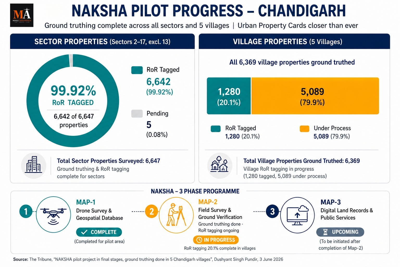
NAKSHA, the National Geospatial Knowledge-based Land Survey of Urban Habitations, is a Government of India pilot run by the Department of Land Resources. Chandigarh was picked as a model city among 157 pilot cities nationwide. The coverage area takes in Sectors 2 to 17 (Sector 13 excluded) and five villages: Sarangpur, Kajheri, Burail, Attawa and Palsora.
The numbers reported this week are striking. All 15 sectors have been surveyed. Of 6,647 sector properties, ground truthing and Record of Rights tagging stand complete for 6,642, a 99.92 percent completion rate. All 6,369 identified village properties have been ground truthed as well.
Village RoR tagging is the remaining gap. Exactly 1,280 of those 6,369 properties have been tagged so far, about 20.1 percent, with 5,089 still under process. That work continues.
The programme runs in three phases:
- Map-1: drone surveys and a geospatial database, already complete for the pilot zone
- Map-2: field surveys and ground verification; ground truthing is complete, village RoR tagging continues
- Map-3: consolidating digital land records and opening them up for governance and public services
The end product residents care about is the Urban Property card, or UrPro card. These ownership documents matter most in Lal Dora village areas, where formal title records have historically been thin or absent. A verified, GIS-linked card changes what a village property owner can do, from securing loans to selling cleanly.
For the wider Tricity, this pilot is worth watching. Chandigarh's village pockets share the same record-keeping ambiguities found in abadi areas across Mohali and the Punjab periphery. If NAKSHA scales beyond the pilot, the same drone-survey-to-property-card pipeline could eventually reach urban villages on the Punjab side, where unclear titles still complicate transactions and slow dispute resolution.
The stated vision behind the programme is one click access to accurate land records, anywhere, anytime. Chandigarh is now closer to that than any city in the region.
Sources:
The Tribune, "NAKSHA pilot project in final stages, ground truthing done in 5 Chandigarh villages", Dushyant Singh Pundir, 3 June 2026
चंडीगढ़ ने NAKSHA ग्राउंड ट्रूथिंग पूरी की — शहरी प्रॉपर्टी कार्ड जारी होने वाले
चंडीगढ़ ने NAKSHA ग्राउंड ट्रूथिंग पूरी की, अर्बन प्रॉपर्टी कार्ड और करीब
चंडीगढ़ के भू-अभिलेख सुधार ने अपनी सबसे बड़ी बाधा पार कर ली है। UT एस्टेट ऑफिस ने NAKSHA पायलट प्रोग्राम के तहत चुने गए सभी पाँच गाँवों में ग्राउंड ट्रूथिंग पूरी कर ली है, जिससे यह प्रोजेक्ट अपने अंतिम चरण में पहुँच गया है।
NAKSHA (National Geospatial Knowledge-based Land Survey of Urban Habitations) भू-संसाधन विभाग (Department of Land Resources) द्वारा संचालित भारत सरकार का एक पायलट प्रोग्राम है। देशभर के 157 पायलट शहरों में से चंडीगढ़ को एक मॉडल सिटी के रूप में चुना गया था। इसके कवरेज क्षेत्र में सेक्टर 2 से 17 (सेक्टर 13 को छोड़कर) और पाँच गाँव शामिल हैं: सारंगपुर, काजेरी, बुरैल, अटावा और पालसोरा।
इस सप्ताह रिपोर्ट किए गए आंकड़े चौंकाने वाले हैं। सभी 15 सेक्टरों का सर्वेक्षण किया जा चुका है। 6,647 सेक्टर संपत्तियों में से, 6,642 के लिए ग्राउंड ट्रूथिंग और Record of Rights (RoR) टैगिंग पूरी हो चुकी है, जो 99.92 प्रतिशत की पूर्णता दर है। सभी 6,369 पहचानी गई ग्रामीण संपत्तियों की भी ग्राउंड ट्रूथिंग पूरी हो चुकी है।
गाँवों की RoR टैगिंग ही अंतिम शेष अंतर है। इन 6,369 संपत्तियों में से अब तक ठीक 1,280 को टैग किया जा चुका है, जो लगभग 20.1 प्रतिशत है, जबकि 5,089 अभी भी प्रक्रियाधीन हैं। यह काम जारी है।
यह कार्यक्रम तीन चरणों में चलता है:
- मैप-1: ड्रोन सर्वेक्षण और एक जियोस्पेशियल डेटाबेस; पायलट ज़ोन के लिए पहले ही पूरा हो चुका है
- मैप-2: फील्ड सर्वेक्षण और ग्राउंड वेरिफिकेशन; ग्राउंड ट्रूथिंग पूरी हो चुकी है, गाँवों की RoR टैगिंग जारी है
- मैप-3: डिजिटल भू-अभिलेखों को एकीकृत करना और उन्हें शासन और सार्वजनिक सेवाओं के लिए खोलना
निवासियों के लिए सबसे महत्वपूर्ण अंतिम उत्पाद अर्बन प्रॉपर्टी कार्ड (UrPro Card) है। ये स्वामित्व दस्तावेज़ लाल डोरा ग्रामीण क्षेत्रों में सबसे अधिक मायने रखते हैं, जहाँ औपचारिक शीर्षक अभिलेख ऐतिहासिक रूप से कम या अनुपस्थित रहे हैं। एक सत्यापित, GIS-लिंक्ड कार्ड गाँव की संपत्ति के मालिक की क्षमताओं को बदल देता है, चाहे वह ऋण प्राप्त करना हो या साफ-सुथरी बिक्री करना हो।
व्यापक ट्राइसिटी के लिए, यह पायलट देखने लायक है। चंडीगढ़ के ग्रामीण पॉकेट मोहाली और पंजाब परिधि के आबादी क्षेत्रों में पाए जाने वाले समान रिकॉर्ड-कीपिंग अस्पष्टताओं को साझा करते हैं। यदि NAKSHA पायलट से आगे बढ़ता है, तो वही ड्रोन-सर्वे-से-प्रॉपर्टी-कार्ड पाइपलाइन अंततः पंजाब की ओर के शहरी गाँवों तक पहुँच सकती है, जहाँ अस्पष्ट शीर्षक अभी भी लेन-देन को जटिल बनाते हैं और विवाद समाधान को धीमा करते हैं।
कार्यक्रम के पीछे बताई गई दृष्टि कहीं भी, कभी भी, एक क्लिक पर सटीक भू-अभिलेखों तक पहुँच है। चंडीगढ़ अब इस क्षेत्र के किसी भी शहर की तुलना में इसके करीब है।
स्रोत:
द ट्रिब्यून, "NAKSHA pilot project in final stages, ground truthing done in 5 Chandigarh villages", दुष्यंत सिंह पुंडीर, 3 जून 2026
Chandigarh NAKSHA Ground Truthing Complete — Urban Property Cards Coming
Chandigarh NAKSHA Ground Truthing ਪੂਰਾ, Urban Property Cards ਵੱਲ ਵਧਦੇ ਕਦਮ
Chandigarh ਦੇ land records overhaul ਨੇ ਆਪਣਾ ਸਭ ਤੋਂ ਵੱਡਾ checkpoint ਪਾਰ ਕਰ ਲਿਆ ਹੈ। UT Estate Office ਨੇ NAKSHA pilot programme ਅਧੀਨ ਚੁਣੇ ਗਏ ਸਾਰੇ ਪੰਜ ਪਿੰਡਾਂ ਵਿੱਚ ground truthing ਮੁਕੰਮਲ ਕਰ ਦਿੱਤੀ ਹੈ, ਜਿਸ ਨਾਲ ਪ੍ਰੋਜੈਕਟ ਆਪਣੇ ਅੰਤਿਮ ਪੜਾਅ ਵਿੱਚ ਪਹੁੰਚ ਗਿਆ ਹੈ।
NAKSHA, National Geospatial Knowledge-based Land Survey of Urban Habitations, Department of Land Resources ਦੁਆਰਾ ਚਲਾਇਆ ਜਾ ਰਿਹਾ Government of India ਦਾ pilot programme ਹੈ। ਦੇਸ਼ ਭਰ ਦੇ 157 pilot cities ਵਿੱਚੋਂ Chandigarh ਨੂੰ model city ਵਜੋਂ ਚੁਣਿਆ ਗਿਆ ਸੀ। ਕਵਰੇਜ ਏਰੀਏ Sectors 2 to 17 (Sector 13 ਨੂੰ ਛੱਡ ਕੇ) ਅਤੇ ਪੰਜ ਪਿੰਡ: Sarangpur, Kajheri, Burail, Attawa ਅਤੇ Palsora ਨੂੰ ਆਪਣੇ ਵਿੱਚ ਲੈਂਦਾ ਹੈ।
ਇਸ ਹਫ਼ਤੇ ਰਿਪੋਰਟ ਕੀਤੇ ਗਏ ਅੰਕੜੇ ਕਮਾਲ ਦੇ ਹਨ। ਸਾਰੇ 15 sectors ਦਾ survey ਕੀਤਾ ਗਿਆ ਹੈ। 6,647 sector properties ਵਿੱਚੋਂ, ground truthing ਅਤੇ Record of Rights tagging 6,642 ਲਈ ਮੁਕੰਮਲ ਹੋ ਚੁੱਕੀ ਹੈ, ਜੋ 99.92 ਪ੍ਰਤੀਸ਼ਤ completion rate ਹੈ। ਪਛਾਣੀਆਂ ਗਈਆਂ ਸਾਰੀਆਂ 6,369 village properties ਦੀ ground truthing ਵੀ ਪੂਰੀ ਹੋ ਗਈ ਹੈ।
Village RoR tagging ਬਾਕੀ ਰਹਿੰਦਾ gap ਹੈ। ਉਨ੍ਹਾਂ 6,369 properties ਵਿੱਚੋਂ 1,280 properties ਦੀ tagging ਹੁਣ ਤੱਕ ਕੀਤੀ ਗਈ ਹੈ, ਜੋ ਲਗਭਗ 20.1 ਪ੍ਰਤੀਸ਼ਤ ਹੈ, ਜਦਕਿ 5,089 'ਤੇ ਕੰਮ ਅਜੇ ਵੀ ਜਾਰੀ ਹੈ। ਉਹ ਕੰਮ ਜਾਰੀ ਹੈ।
ਇਹ programme ਤਿੰਨ phases ਵਿੱਚ ਚੱਲਦਾ ਹੈ:
- Map-1: drone surveys ਅਤੇ geospatial database, pilot zone ਲਈ ਪਹਿਲਾਂ ਹੀ ਮੁਕੰਮਲ
- Map-2: field surveys ਅਤੇ ground verification; ground truthing ਮੁਕੰਮਲ, village RoR tagging ਜਾਰੀ
- Map-3: digital land records ਨੂੰ consolidating ਕਰਨਾ ਅਤੇ governance ਅਤੇ public services ਲਈ ਉਹਨਾਂ ਨੂੰ ਖੋਲ੍ਹਣਾ
ਅੰਤਿਮ product ਜਿਸ ਬਾਰੇ ਨਿਵਾਸੀ ਚਿੰਤਤ ਹਨ, ਉਹ Urban Property card, ਜਾਂ UrPro card ਹੈ। ਇਹ ownership documents Lal Dora village areas ਵਿੱਚ ਸਭ ਤੋਂ ਵੱਧ ਮਹੱਤਵਪੂਰਨ ਹਨ, ਜਿੱਥੇ formal title records ਇਤਿਹਾਸਕ ਤੌਰ 'ਤੇ ਘੱਟ ਜਾਂ ਗੈਰ-ਮੌਜੂਦ ਰਹੇ ਹਨ। ਇੱਕ verified, GIS-linked card village property owner ਲਈ loan ਪ੍ਰਾਪਤ ਕਰਨ ਤੋਂ ਲੈ ਕੇ cleanly sell ਕਰਨ ਤੱਕ, ਬਹੁਤ ਕੁਝ ਕਰਨਾ ਸੰਭਵ ਬਣਾਉਂਦੀ ਹੈ।
ਵਿਆਪਕ Tricity ਲਈ, ਇਹ pilot ਦੇਖਣਯੋਗ ਹੈ। Chandigarh ਦੇ village pockets Mohali ਅਤੇ Punjab periphery ਦੇ abadi areas ਵਿੱਚ ਪਾਏ ਜਾਣ ਵਾਲੇ record-keeping ambiguities ਨੂੰ ਸਾਂਝਾ ਕਰਦੇ ਹਨ। ਜੇਕਰ NAKSHA pilot ਤੋਂ ਪਰੇ scale ਹੁੰਦਾ ਹੈ, ਤਾਂ real-estate drone-survey-to-property-card pipeline eventual-tually Punjab side ਦੇ urban villages ਤੱਕ ਪਹੁੰਚ ਸਕਦਾ ਹੈ, ਜਿੱਥੇ unclear titles ਅਜੇ ਵੀ transactions ਨੂੰ complicate ਕਰਦੇ ਹਨ ਅਤੇ dispute resolution ਨੂੰ slow ਕਰਦੇ ਹਨ।
Programme ਦੇ ਪਿੱਛੇ stated vision one click access to accurate land records, anywhere, anytime ਹੈ। Chandigarh ਹੁਣ ਖੇਤਰ ਵਿੱਚ ਕਿਸੇ ਵੀ city ਤੋਂ ਵੱਧ ਇਸ ਦੇ ਨੇੜੇ ਹੈ।
Sources:
The Tribune, "NAKSHA pilot project in final stages, ground truthing done in 5 Chandigarh villages", Dushyant Singh Pundir, 3 June 2026